The 2026/27 El Niño is continuing to strengthen, with a strong possibility that it could become a historically strong or “super” El Niño. It is expected to pick up during the December–February period, when coastal communities may experience more frequent and intense storms, rainfall, and high wave conditions.
If you live along California’s coast, now is a good time to prepare your property for strong storms, heavy rainfall, large waves, flooding, and erosion.
Before storms arrive, coastal residents and communities are encouraged to:
Some types of preparation or response activities may require a permit. If you are unsure whether planned work requires a permit, please contact Commission staff before beginning.
El Niño is a natural climate cycle, but changes in ocean and atmospheric conditions may affect how often and how strongly these events occur. As ocean temperatures rise, El Niño events may change in frequency and intensity.
For California’s coast, El Niño can contribute to stronger storms, heavier rainfall, larger waves, coastal flooding, and beach erosion. Rising sea levels can make these impacts more significant and allow flooding and storm impacts to reach farther inland.
The 2015/16 El Niño was one of the strongest of the past 145 years. It brought exceptionally large waves along the West Coast and caused significant beach erosion across the region.
That experience highlights why taking steps before storms arrive can help coastal residents reduce potential damage.
Below is additional resources for property owners and local governments, about El Niño, ways to prepare, information on permitting procedures and more. This page will be regularly updated as materials become available.
Remember to listen to local officials and stay tuned to official sources such as the NOAA National Weather Service for advisories, watches, and warnings.
Last updated 9/11/2026
Local governments and property owners are encouraged to assess their situations or properties in preparation for the winter and to reach out for consultation or direction. If there is a certified Local Coastal Program, property owners should contact the local government staff directly. If the work involves any shoreline protection or bluff work, property owners should contact both local government staff and Commission staff. If desired work is in response to an emergency, please contact Commission staff and your local government as quickly as possible to determine what type of permit is needed.
In anticipation of a potentially intense storm season, Commission staff encourages coastal communities and residents to prepare by inspecting their property and completing routine maintenance that can help reduce possible storm-related damage. Some tasks may need to be revisited throughout the season or following each storm. Activities that are more involved or that could potentially impact coastal resources may require a coastal development permit. This includes work that involves grading, landform alteration, or using mechanized equipment on the beach or near a coastal floodplain or bluff. If you are unsure whether your planned activity requires a permit, please contact your local Commission staff for guidance. Many activities can be reviewed quickly, and in some cases permits may be waived or expedited. To avoid violations and ensure you can move forward promptly, please reach out to Commission staff before beginning any work.

Coastal communities and their local governments can prepare for El Niño by checking debris basins and flood control channels, storm drains and culverts, community buildings, and shoreline protection devices falling under their ownership or maintenance agreements. Being aware of where recent fires within the watershed have denuded slopes or hillsides can help identify areas vulnerable to mudslides and debris flows. Designating temporary stockpile sites for localized slides, debris flows, or slumps that may affect public services is another preemptive measure. Along waterfronts, plans for breaching closed estuaries that present a flood risk to adjacent areas, or building up temporary beach berms with sand may be effective ways to prepare. Where existing programs or permits exist for opportunistic sand placement, local governments are encouraged to pursue nourishment in advance of storms. Outreach efforts to educate and discuss options with local residents may also prove helpful. See the Commission’s Community Preparedness Suggested Steps for more information.

In general, residents can prepare for severe storms by inspecting roofs, retaining walls, and slopes for any signs of wear or damage that could worsen during or after intense rainfall. Cleaning drains and gutters around a property and visually checking for obstructions around nearby storm drains are other good practices. In the latter case, if there are potential problems, notify any responsible agencies to request maintenance. Ensuring that yard areas are free of dead trees or limbs, debris, furniture, or anything else that may be susceptible to strong winds can reduce damage risk. Large swaths of bare ground or exposed soil can be readily protected by covering the area with mulch, vegetating with native plants, or securing it with outdoor fabrics. See the Commission’s General Property Preparedness Suggested Steps for more information.

Shoreline properties face several additional risks during large storm events. Structures that currently protect property from waves and erosion (such as seawalls, revetments, and cave fills) should be inspected for signs of distress, loss of material, obstructed drainage, etc. Beach and shore-facing areas should be cleared of unsecured placed objects (e.g., furniture) that may potentially become battering rams or damaging projectiles during a storm. Blufftops and slopes should also be inspected for instability or potential drainage issues. Temporary and removable protection (such as sand bags, sand berms, and beach nourishment) may be considered if there is a need for extraordinary protection, but in many cases will require a permit – please contact Commission staff before undertaking such measures to discuss options. See the Commission’s Shoreline Property Preparedness Suggested Steps for more information.
Emergency permits may become necessary when sudden, unexpected events occur, requiring immediate action to prevent or mitigate loss of life, health, property, or essential public services. Coastal Act, and most Local Coastal Programs, provide for the authorization of such permits, though the process is meant to allow for only the minimum amount of temporary measures necessary to abate the emergency rather than the installation of substantial protective works that might not otherwise be allowed. Emergency coastal permits authorize development temporarily, and anything intended to be kept for the longer term will be required to obtain a regular coastal development permit. If you think you need an emergency permit, please contact Commission staff as quickly as possible to determine whether your case meets the necessary criteria. The Commission’s emergency permit application is available here.
Recovering from storm-season damage often requires addressing issues such as removing major debris, stabilizing landslides, or reinforcing structures. If these development activities were not previously authorized, a regular coastal development permit may be required. If an emergency permit was granted earlier in the season, an additional coastal development permit may be necessary. By design, emergency permits authorize only temporary actions needed to address an immediate threat to life, health, property, or essential public services. To maintain or construct any development beyond what the emergency permit allows, a regular coastal development permit must be obtained. For more information about coastal development permits and when they are required, contact Commission staff to discuss specific cases. Coastal development permit application forms may be found here
From critical infrastructure to private residences, public access, land and marine resources, and local economies, El Niño events have historically affected coastal resources across California. Because the nature of each El Niño is shaped by an array of ever-changing climatological forces, the impacts also vary from one event to another. In many cases, the extent of impacts will depend on the coincidence of waves, winds, tides, precipitation, and other factors as well as their intensities. The 1982/83 and 1997/98 El Niños have been among the most damaging and well-documented events in the modern record (both are classified as 'extreme' events) and illustrate the magnitude of impacts El Niño can have in California.
Coastal hazards associated with extreme El Niño events include waves (as sources of flooding and erosion), landslides, debris flows, road closures, oil and sewage spills, and structural damage. In the wake of the 1982/83 El Niño, the US Army Corps of Engineers reported 33 ocean front homes had been destroyed and that another 3000 homes along with 900 coastal businesses were damaged by associated storm surge, waves, erosion and other forces. (1984 Task Force Report: Coastal Storm Damage, Winter 1983). During the 1997/98 El Niño event, there were 17 storm-related deaths in California and at least 27 homes were red-tagged (declared unsafe for human habitation or entry by local officials) within the coastal zone. While the 2015/16 El Niño winter did not bring extraordinary rainfall, it did cause record coastal erosion along many California beaches, including an average of around 150 feet of erosion for Central California (Smith & Barnard, 2020), and triggered over 67 El Niño-related permit actions by the Commission. During the 2023/24 El Niño, California saw well above average precipitation in coastal southern California and slightly above normal precipitation in coastal regions of northern California triggering landslides such as those along the LOSSAN rail corridor in January of 2024.
The economic cost of damages associated with El Niño has been significant in past decades:
1982/83 El Niño |
1997/98 El Niño |
|
|---|---|---|
Statewide |
$300 million (2023 value) $100 million (1983) |
$1.03 billion (2015 value) $550 million (1998) |
Coastal resources |
To public recreational facilities: $106 million (2023 value) $35 million (1983) Portion for 17 public recreational piers: $58 million (2023 value) $19 million (1983) |
To state beaches: $3.36 million (2015 value) $1.8 million (1998) |
Federal response |
Presidential Major Disaster declared for all coastal counties; 8700 applicants for disaster assistance from FEMA or SBA |
El Niño years are often marked by severe winter storms that bring high levels of precipitation to California’s coast. On land, this can translate to increased erosion, flooding, and landslides, all of which can directly affect terrestrial, aquatic, and marine ecosystems. For example, fire-scarred areas where major vegetation has been burned are particularly vulnerable to further impacts, including the loss of soils rich in organic material and native seedbanks, both critical to post-fire recovery. Watercourses may experience abnormal sediment loads that bury important salmonid microhabitat, or larger flows that prolong seasonal lagoon closures, and thus, by affecting tidal incursions and upstream salinity, impact habitat use for species like California red-legged frogs, water temperatures influencing anadromous fish development, or hydrodynamic refuge for species like tidewater gobies. Off the coast of California, El Niño is often associated with a relaxation of upwelling (the transport of cold, nutrient-rich water to the ocean’s surface), which in turn results in reduced ocean productivity with cascading effects that reduce the food supply for fish, seabirds, and marine mammals. Additionally, elevated sea surface temperatures can result in or exacerbate “marine heatwaves,” that may promote shifts in species ranges (whether to escape or exploit thermal conditions). The physiological stresses imposed on organisms can result in increased rates of mortality and disease in marine populations during these warmer periods.
The El Niño Southern Oscillation (ENSO) is a naturally occurring cycle driven by interactions of oceanic and atmospheric forces in the equatorial Pacific Ocean. Influencing climate globally, the ENSO cycle has three phases – El Niño, La Niña, and neutral – often defined by sea surface temperature patterns in particular regions of the equatorial Pacific. Neutral phases are defined by sea surface temperature patterns corresponding to the long-term average, while El Niño and La Niña phases correspond to significant warm and cold anomalies, respectively. The ENSO cycle tends to recur every 2-7 years with El Niño and/or La Niña conditions typically lasting 6-18 months at a time. El Niño and La Niña phases are considered asymmetric, with El Niño phases occurring slightly more frequently and tending to exert disproportionately stronger effects on regional climate than La Niñas.
During an El Niño phase, warm water builds up across the equatorial Pacific Ocean and spreads eastward to the coasts of North and South America, affecting circulation patterns in both the ocean and atmosphere. Along the California coast, sea levels temporarily increase storm trajectories shift, redirecting precipitation from the Pacific Northwest and Alaska towards California. As the warm water floats over denser, cooler water, ocean thermoclines deepen and effectively block the upwelling processes that deliver essential nutrients to coastal ecosystems. Over the past several decades, scientists have become increasingly adept at forecasting the onset of El Niño conditions by interpreting patterns in the ocean and atmosphere; however, it remains challenging to predict the intensity, frequency, and duration of any given El Niño event due to interactions with the multitude of other factors also influencing climate (e.g., the Pacific Decadal Oscillation or atmospheric patterns such as the high pressure ridges. For technical information about El Niño forecasts and current conditions, visit the National Weather Service’s Climate Prediction Center.
Recent science suggests that changes in the global climate could intensify ENSO patterns in the future, increasing both the strength and frequency of observed El Niño and La Niña phases. Using 20 different models, Cai et al (2014) explored the potential effects of greenhouse warming on El Niño frequency in the 21st Century and found strong evidence for a doubling of extreme events like those observed in 1982/83 and 1997/98. In a related 2015 study, they made similar findings concerning extreme La Niña events, with 75% of these being likely to occur in the year following an extreme El Niño. Other work by Barnard et al (2015) has shown that coastal erosion in California increases by over 69% during extreme El Niños and is primarily driven by increases in wave stress (i.e. energy and directional shifts) and sea level. More recently, Vos et al (2023) has shown erosion of California’s beaches is particularly correlated with the ENSO pattern. Taking this into consideration collectively, the implication of this research is that California will continue to be susceptible to increasingly extreme and episodic coastal hazards in the future.
Independent of future global sea level rise projections, El Niño conditions contribute additional periodic increases in sea surface height as the warm water expands and storms approach the coastline. This seasonal increase in sea levels make low-lying areas particularly vulnerable to extreme high tides such as King Tides which can cause coastal flooding much further inland than normally observed.
NOAA is tracking the on-going 2026/2027 El Niño closely, and issued an El Niño Advisory in June of 2026. As of September 2026, the El Niño is strengthening and is expected to persist into the Northern Hemisphere spring of 2027. NOAA estimates there is about a 69 percent chance that the current El Niño continues to develop into a historic event that would exceed the strength of previous El Niño events dating back to 1950. As we enter the winter months of 2026-27, NOAA, including the National Weather Service, will continue to communicate the latest forecasting science and potential impacts of individual storm and wave events. Key links to find more information can be found below:
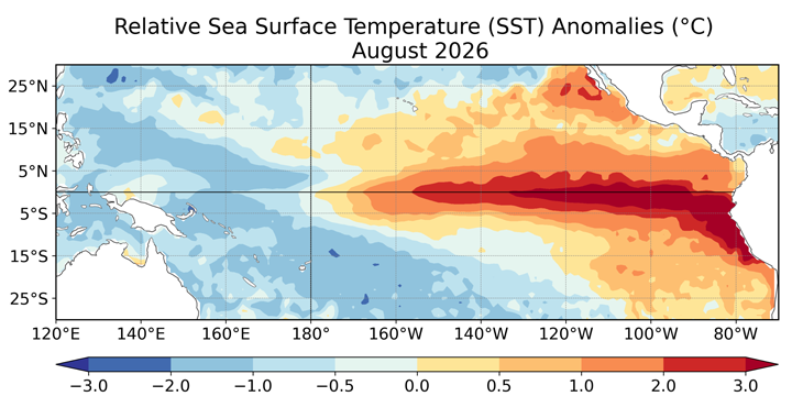
Figure 1. Average relative sea surface temperature (SST) anomalies (C) for August 2026. Anomalies are computed with respect to the 1991-2020 base period monthly means. Data:OISSTv2.1.
https://www.cpc.ncep.noaa.gov/products/analysis_monitoring/
enso_update/Monthly_RelSSTA_map-hr.png
Average relative sea surface temperature anomalies along the equatorial Pacific Ocean observed for July, 2026, with noticeable warming in the eastern Pacific Ocean. Image source: NOAA Climate Prediction Center

California’s precipitation (as % of normal) during six historical El Niño events illustrates that while increased precipitation is often associated with El Niño, it may be limited to only some parts of the state while others experience water shortages.

In California, coastal flooding results from the additive effects of several factors including daily tides, King Tides, El Niño, coastal storm surge and waves. This infographic illustrates how a seaside structure that may be safe from daily tides can be quickly threatened during a winter storm, particularly during an El Niño event. Image source and additional detail available at: National Ocean Service.
