
Cumulative impacts to coastal access result from the overall loss of coastal recreation opportunities. Defined broadly, these opportunities include not only the physical availability of beach sites, but also the ability to reach and utilize those sites. In the ReCAP area, most impacts have occurred: (1) due to incomplete mitigation of development projects, (2) as a result of physical beach loss due to the construction of shoreline protective devices, and (3) due to overall increases in use of recreational sites. The increase in use of beach areas leads to overall congestion, strains on the available facilities, and impacts to site quality, all of which affect use of recreational sites. In addition, increasing use often leads to impacts on sensitive habitat.
One goal of the California Coastal Management Program is to ensure maximum coastal access in balance with coastal resource protection. In the ReCAP region, the overall supply of physical access to and along the coast improved significantly since 1981, due to the addition of several new accessways and improvements to existing access sites. Many of these improvements result from conditions required by the Commission or local governments to mitigate impacts on access from individual development projects. The availability of coastal access for physically challenged users also increased. In addition, both the California Department of Parks and Recreation and the Monterey Regional Park District purchased land for public use, which has enhanced coastal access.
However, cumulative impacts to coastal access opportunities are evident throughout the region. In part, this is because required mitigation of development projects impacting coastal access is often incomplete. For example, a primary tool used to mitigate impacts is the use of an offer to dedicate an access easement for public use; of the 92 offers required at this time, only one has been currently opened and available for the public in the ReCAP region. Thus, one of the major implementation tools for addressing impacts to public access is not fully mitigating those impacts. Several of ReCAP's recommendations will result in improving the effectiveness of current mitigation efforts.
In addition, as overall growth and demand for access continue, even if the maximum supply of physical access is available for public use, impacts to other aspects of access will become increasingly critical, particularly with regard to parking and transit accessibility, the availability of support facilities, the overall quality of the recreational experience. The impacts to these other variables often cannot be easily tied to a specific development project, and therefore become difficult to fully mitigate through a project-by-project review of development proposals. Improvements in how permit review analyzes public access and improved regional planning for access will help address these cumulative impacts. A number of ReCAP's recommendations, including the development of beach and regional management plans, are designed to initiate these improvements.
Due to the historic importance of coastal recreation in the ReCAP area, providing for and managing public coastal access into the future is vital. A primary mandate of the Coastal Act, to provide maximum access to and along the shore, is required by the California Constitution under Section 4, Article 10. After the Coastal Commission certifies a jurisdiction's Local Coastal Plan (LCP), the local government assumes responsibility for implementing the Coastal Act's goals and objectives on a local level, including providing maximum public access. Access is also managed by some nongovernmental managers and the California Department of Parks and Recreation (DPR). DPR is required to develop a comprehensive recreational policy for California; this policy incorporates coastal areas, although the plans do not specifically discuss coastal recreation. In the pilot region, DPR manages 11 coastal units; a twelfth (Lighthouse Field State Beach) is owned by DPR, but managed by Santa Cruz City.
To ensure maximum public access, the Coastal Commission and local governments must both protect existing access and ensure the availability of future access commensurate with a growing demand. Several policies in the Coastal Act serve to meet this objective: the Coastal Act requires that development will not interfere with the public's right to the sea (Section 30211); specifies the need to protect ocean front land suitable for recreational use (Section 30221); and requires the protection of upland areas to support coastal recreation, where feasible (Section 30223). Most of the LCPs in the region specify various projects to enhance the physical supply of coastal access and require access dedications as a mechanism to mitigate access impacts from new development along the shore.
However, the objective of providing coastal access must often be achieved consistent with other Coastal Act objectives: ensuring public safety (Section 30212); protecting sensitive habitat and species (Sections 30212, 30214); protecting agricultural use (Section 30212); and protecting private property rights (Section 30214). As a result of these objectives, access may not be appropriate at every street end or may need to be managed. As development and population increase, the need to balance these objectives in determining how to "maximize" access will also increase.
There are a variety of ways to define coastal access and to assess cumulative impacts to access. Coastal access is generally viewed as an issue of physical supply. The supply of access can be described as lateral access (access across a beach), vertical access (access from the upland street or bluff to the beach), trails above the coast (for example along a blufftop), or upland trails that lead to the coast. ReCAP focused primarily on an assessment of lateral and vertical access immediately along the shoreline. It should be noted however that upland trails form a vital component of an access network.
While the physical supply of access is a primary factor in assuring access opportunities, an access program cannot view the issue of supply in isolation of a number of other factors, as illustrated in Figure 4-1. These variables include: availability of transit to beaches; parking availability; providing other necessary support facilities, such as restrooms and picnic areas; addressing user demands and conflicts; and maintenance of a diversity of coastal recreational experiences. Impacts to any one of these variables may ultimately affect the availability and use of the physical supply of access. For example, without adequate parking or alternative transportation, users will have difficulty reaching an access site. Similarly, a lack of adequate support facilities or a site that is perceived as over-crowded may make a site less desirable for some users. In other cases, the development of extensive support facilities, which often draws a larger number of users, may not be appropriate. Therefore, managing coastal access and ensuring that growth and development does not cumulatively impact the resource, involves managing not only the physical supply of access, but all the other variables that contribute to ensuring maximum coastal access.
Figure 4-1: Access System Diagram. Sources of Impacts to Access. Click here to view Figure 4-1.
The Coastal Act and LCPs have policies directed at several of these other variables. The Coastal Act identifies the need to enhance access to the coast by providing transit service and/or adequate parking (Section 30252), the need for support facilities (Section 30223), and the need to distribute facilities throughout the coastline (Section 30212.5). Most of the LCPs also recognize the need for beach parking and alternative transit options.
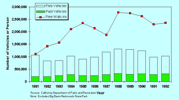
Available data indicate that beach use has increased in the ReCAP area. Figure 4-2 and Figure 4-3 show levels of use for the City of Santa Cruz and DPR beach areas in the region.[1] Using a linear regression, these figures indicate a 45% increase in use for Santa Cruz City beach between 1982 and 1993. For State Parks, the increase in use is 83% in walk-in users, 18% in vehicles which pay no fee, and 55% in paid vehicles during approximately the same time period. If numbers of vehicles are converted to numbers of people, using DPR conversion factors,[2] the overall increase in use for the region's State Parks is approximately 50%. Comparison of this increase in use with the growth in population in the Santa Cruz and Monterey Counties indicates that beach use grew twice as fast as population increase during the same time period.[3] Since at least part of the growth in use is apparently from tourism, planning for adequate coastal access must address use issues beyond the local area, particularly issues such as parking and transit availability.
Figure 4-2: Santa Cruz City Beach Use, 1982-1993
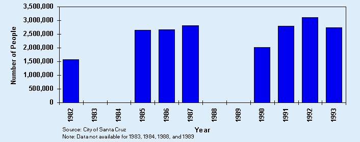
Figure 4-3: Use in Coastal State Park Units, 1981-1992
Coinciding with this overall increase in use is a rise in specialized sports, particularly, surfing, jet-skiing and other use of thrill craft, wind surfing, diving, hang-gliding, mountain biking on trails and on sandy beaches, equestrian riding, kayaking, and diving.[4],[5],[6],[7],[8] Demand for boating facilities has also increased. Both Santa Cruz and Monterey harbors have historically been unable to meet demand for berths, and both have extensive waiting lists.[9],[10] With an increase in use and a diversification of activities in fairly confined areas, conflicts between users also become more common.[11],[12],[13] This trend of increasing use and diversifying activities leads to many of the cumulative impacts evident in the region.
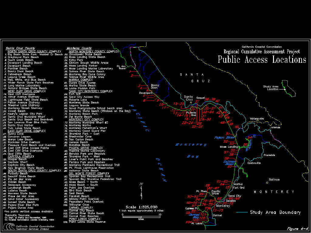
Increasing use generally leads to demand for additional supply, although an increase in supply may in itself generate more use by drawing more people to the area. Overall, the supply of lateral and vertical access in the pilot region has increased since 1981, both through the opening of several new beach areas and new stairways, and through significant improvements to existing areas of use by formalizing paths. (See Figure 4-4 for location of access sites identified by ReCAP.) Numerous other projects enhanced access by providing easier lateral access along the coast; these include the Monterey-Pacific Grove Recreation Trail, the Spanish Bay Recreation Trail, improved access to the Santa Cruz Harbor, bike paths in Santa Cruz, and trails along several wetlands. (See Appendix A for detailed access improvements in the ReCAP area.)
Figure 4-4: Access Location Map FIGURE 1-4, CONT.ANALYSIS. Click here to view Figure 4-4.
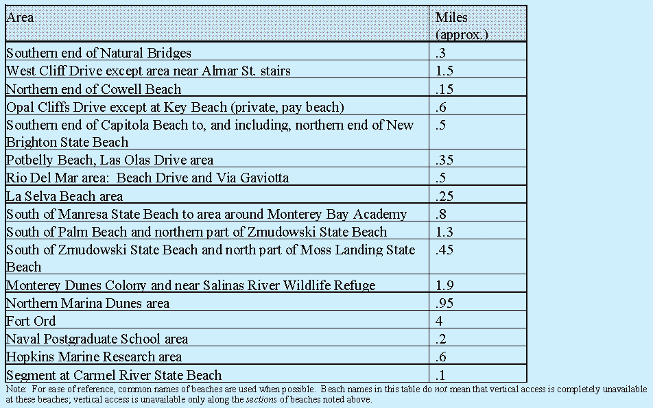
In order to meet the demand for the region and minimize overburdening of sites, vertical access sites should be distributed throughout the area. One measure of whether access is distributed and maximized is to compare available access opportunities with established standards. Both the Santa Cruz County and Monterey County LCPs have adopted standards for vertical access for urban and rural areas.[14] Based on these standards, approximately 75% of the ReCAP coastline that is physically suitable for public access currently provides such access; only about 15 miles of the shoreline that could support access, do not[15] (see Table 4-1). However, although vertical access is not provided at these areas, many have good lateral access.
Table 4-1: Shoreline Areas in ReCAP Region that do not Meet LCP Vertical Access Standards in 1994
A second key issue in assessing the adequacy of public access is determining if improvements are keeping pace with population growth, use, and/or new development in the area. As noted in the Regional Overview section of this report, the ReCAP area has experienced significant development and population growth since 1981. Much of this growth has probably contributed to an overall increase in recreation use, even though much of the new development may not be in the coastal zone. Most areas in the ReCAP region show a general correlation between increased population and/or development and improved access. Physical access in Santa Cruz County improved approximately 36%, while access in Monterey County improved approximately 8%, leading to an overall increase for the region of approximately 21%. (For a full discussion of this analysis and how access was quantified, see Appendix B.)
Overall growth and development in the Monterey Bay area is expected to continue, although the amount of new development in the coastal zone may be minimal as the amount of vacant land diminishes. The use of access areas will also likely continue to increase, due both from increasing use within the region as population growth increases and from continued tourism from other areas. However, the amount of additional physical access possible is limited. Many beaches in the pilot region that currently do not support coastal access are unlikely to be able to support it in the future, due to geographic constraints or conflicts with other uses. Santa Cruz County currently provides access at approximately 88% of maximum possible; Monterey County currently provides access at approximately 59% of maximum. Overall, the ReCAP region provides access at 71% of maximum possible.[16] (For a complete discussion of how maximum access was calculated, see Appendix B.) While these figures indicate the possibility of some additional access, particularly with the future development of coastal access at Fort Ord, ultimately the supply will become saturated. At that point, adding another stairway will have minimal benefits for coastal access. As use continues to grow, factors such as accessibility to sites and maintaining the quality of access sites will play an increasingly vital role in ensuring that maximum access is available to the population.
Since the above analysis indicates that the physical supply of access has generally kept pace with growth and development in the region, ReCAP focused additional analysis on some of the other variables that affect access. Based on available data and discussions with local recreation managers, ReCAP focused on: (1) the effectiveness of mitigation measures; (2) impacts from seawalls; (3) possible resource/access conflicts; (4) impacts to parking and accessibility to the coast; (5) access issues with regards to changing demands and demographics; and (6) the need for a more regional approach to access planning.
To be fully effective in mitigating impacts to access from development, offers-to-dedicate must be recorded, accepted, and available for public use. Additional mechanisms may also be needed in the future to supplement the offer-to-dedicate process.
Impacts to the physical supply of access from development may be evident through encroachment onto beach areas, blockage of accessways, and overall increases in use. One of the major tools that the Commission and local governments use to mitigate impacts on the physical supply of public access from new development is a condition requiring an offer-to-dedicate (OTD) a public access easement. OTDs are generally required only for development between the first public road and the sea. Although specific language varies, LCPs generally require an OTD as a mechanism to implement access mitigation. A lateral easement (along the beach) is generally required to compensate for the impacts to public use when development encroaches onto a public beach or impacts existing public access; a vertical easement is generally required when development would block access to the beach from the upland road or bluff. The easements themselves, however, do not ensure the availability of public access: once recorded as an OTD, the offers must then be accepted for management, and opened and managed by a public agency or acceptable nongovernmental association before the land becomes available for public use. LCPs do not currently require local governments to accept offers. Review of the OTD process in the ReCAP area indicates that: (1) the OTD recordation process and acceptance needs improvement; (2) exemptions limit the use of OTDs; (3) a review of whether OTDs are on public or private land is often not done; and (4) additional mechanisms may be needed in the future to supplement the OTD process. All these issues, discussed separately below, point to improvements needed to increase the effectiveness of OTDs in mitigating impacts on the physical supply of access.
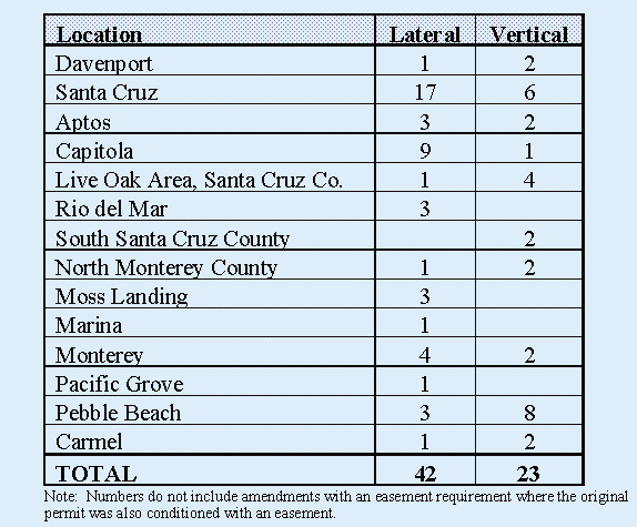
Under the Coastal Act, the Commission has required 42 lateral and 23 vertical OTDs in the ReCAP region to mitigate the impacts of new development. Under the LCPs, local governments required another 6 lateral and 8 vertical OTDs[17] (see Table 4-2). In general, the Commission and local governments required OTDs for shoreline protective devices, commercial development, subdivisions, and occasionally single family residences. Additional permits granted by the Commission and local governments incorporate access to the beach into the project and therefore are not conditioned with OTDs.
Table 4-2: Lateral and Vertical OTDs Required by Coastal Commission and Local Governments
Generally, when the Commission or local government requires an OTD for mitigation of a development project, the condition language requires that the OTD be recorded prior to issuance of the coastal development permit. In some cases, the applicant will choose not to pursue an approved project, and will not need to meet conditions of a permit or obtain the permit. Since it is difficult to determine from Commission filing logs which permits have actually been issued, ReCAP attempted to verify issuance of coastal development permits using local government approvals. After a project is approved by the Commission, but prior to issuance of a coastal development permit, applicants must receive local building or grading permits. For those projects that required an OTD, but did not have one recorded, ReCAP attempted to determine if these local permits were issued. For those that did receive local permits, ReCAP assumed that the coastal development permit was also issued, and the OTD requirement would be in effect. For projects not receiving local permits, ReCAP assumed that the coastal development permit was also not issued, and since the new development would not be pursued, compliance with the OTD condition was not required.
Of the 79 projects requiring an OTD, eight had no building or grading permits issued; local permits for five projects could not be verified. Excluding the eight projects that had no local permit, 24 projects, approximately 30% of those projects requiring an OTD, did not have one recorded (36 lateral, 23 vertical).[18] Of those recorded, some were done only after an enforcement action to ensure compliance with permit conditions. The impacts from the remaining projects have not yet been mitigated, resulting in a cumulative loss of beach access. To improve recordation of OTDs, the Commission and local governments need to improve information tracking on projects with easement requirements. ReCAP has initiated steps to improve previous Commission access inventories to better track OTD requirements.
Further, until the OTDs are actually opened, the impacts from the development are not fully mitigated as the land is still not available for public use. To date, only six of the recorded OTDs have been accepted by a managing agency and only one vertical accessway is actually open for public use.[19] One barrier for local governments or private associations, including non-profit organizations, in accepting OTDs is a concern over potential liability; both Santa Cruz County and the City of Pacific Grove have indicated that liability is a concern in managing access areas.[20],[21] Section 831.4 of the State Government Code provides limited immunity for public entities managing land for public recreation. Non-profit organizations are protected under similar immunities for accepting coastal access easements if they enter into an agreement with the State Coastal Conservancy. Despite these immunities, concern over the extent of protection remains. Guidance via case law is limited; because of this uncertainty, liability will likely remain a concern limiting the acceptance of OTDs.
It is unlikely, however, that resolving the issue of liability will completely address the hesitancy of agencies to accept OTDs. Perhaps more of a constraint is the need to maintain an accessway once it is accepted, and the associated costs involved. This issue was identified early in the access program as a constraint to accepting OTDs, and remains an issue today.[22],[23] Given the current problem of funding maintenance programs, the reluctance to open new accessways will probably continue until agencies or governments are assured of sufficient funding or alternatives.
In reviewing development proposals for impacts on access, the Commission and local governments may exempt development proposals from requiring OTDs when access would conflict with public safety, habitat, agriculture or military use, or where "adequate access" exists nearby. Since 1983, the Commission and local governments exempted a total of 291 permits from OTD requirements in the ReCAP region. For many of these developments, the Commission and local governments did not require other access mitigation. Of the exemptions, 151 were exempt due to a finding of adequate access.[24] However, the Coastal Act provides no guidance for what constitutes "adequate access". The Statewide Interpretive Guidelines suggest that adequate access cannot be found laterally along any beach. For vertical access, analysis of whether adequate access exists should consider: (1) the amount of public use; (2) availability of support services; and (3) the location of pocket beaches.[25] Only two LCPs provide any guidance as to the amount of vertical access that is appropriate: the Santa Cruz County LCP requires vertical access every 1/4 mile in rural areas and every 650 feet in urban areas; the North Coast segment of Monterey County LCP requires vertical access every 1/4 mile.
Review of adopted permit findings generally discuss only whether vertical access is physically located nearby a proposed development, but do not take into account increasing use of a site, availability of facilities, or the quality of a site, all of which cumulatively affect access. Multiple development proposals will often cite the same accessway to indicate that an area has "adequate existing access". For example, eight permits cited the 26th Avenue accessway in the Live Oak area as a reason for not requiring additional access mitigation to address impacts of new development. None of the permit findings analyzed the cumulative impacts from multiple development projects, the effect on the site from past increases in use due to adjacent development, any growing need for facilities -- especially parking -- due to increased use, or when new development begins to overburden the site. All of these factors affect whether an existing accessway is truly "adequate".
Further, local governments exempted a number of permits from access mitigation due to findings of development being too dense to accommodate access, lots being too small to accommodate access, and sites not being designated as access sites in an LCP. However, in areas of dense development, the demand for access is probably high. Continued development will increase the demand for access and will overburden other access sites if additional access is not provided. One method of addressing these impacts is to develop a program of in-lieu fees for maintenance of existing accessways near the site location, the development of support facilities, or the development and maintenance of other accessways. For example, a policy in Sand City's LCP states that where a dedication of access is not feasible, payment of an in-lieu fee for development and maintenance of other accessways should be done.
In order for an OTD to provide mitigation for development, the OTD should be on land that is not already publicly owned. To determine whether OTDs were being recorded against already public land, ReCAP reviewed permit files for a State Lands determination of the boundary between public and private land. This determination would indicate if projects, and the mitigating OTDs, were on public, state owned lands. Only 18 of the 40 projects conditioned with a lateral easement also required a determination by State Lands. For six of those projects, State Lands determined that the development was probably not on public land, but did not make a final determination. For these projects, it is likely that the OTDs are also on private land, thereby providing mitigation for the impacts from development. Of the remaining projects requiring State Lands review, seven had no determination in the file, and five files were not located in the Santa Cruz office. (Due to limited resources, staff was not able to check missing files in archives.) Since State Lands review is not completed for most of the projects, ReCAP could not determine the extent to which these OTDs are recorded on already public land.
Even though conditioning a permit to require an OTD is one of the primary methods to mitigate impacts on access, additional mechanisms may be needed in the future to supplement the OTD process. Recent court cases have emphasized the need to fully document impacts from development projects in order to mitigate those impacts. Due to the nature of cumulative impacts, documenting the contribution of a single project to the overall impacts on access can be difficult. As buildout of a region and use of an area continues, the cumulative impacts on access continue; it is these impacts both to the physical supply of access and to other variables that comprise an access system which cannot be solely mitigated through review of permits and conditions requiring an OTD.
Further, the use of OTDs, even in cases where impacts can be fully documented, is likely to decrease. Staff review of aerial photos and land use maps reveals few vacant lots or areas of future subdivisions between the first public road and the sea. Further, since most of the pilot region conforms to access standards set forth in the LCPs, new development would likely be exempt from access requirements if adequate access nearby is determined under current procedures. Therefore, the Commission and local governments will have fewer cases where access impacts can be mitigated through project specific review and the use of access easements. The lack of available shorefront parcels, however, does not necessarily mean a decline on impacts to coastal recreation and access; inland subdivisions and development will continue to draw additional people to the existing accessways, as will continued tourism.
Given the limitations in the ability of OTDs to address the cumulative impacts to access, additional mechanisms should be developed to supplement this program. Ultimately an increase in vertical access easements or actual access points would have minimal benefit as the supply reaches saturation. When the availability of physical access is maximized, the question becomes one of managing an increasing and concentrated use, rather than increasing supply. The use of OTDs cannot address these issues. Development of a regional plan for public coastal access could help ensure continued access and could ensure that a number of other variables are addressed. The development of such plans is discussed under Access Problem #6. However, OTDs should continue to be used to mitigate site specific impacts to the physical supply of access.
The use of shoreline protective devices negatively impacts shoreline access by encroaching onto beaches, leading to a loss of recreational beach area. Current mitigation efforts to minimize these impacts are not fully effective.
As noted in Section 3 of this report, shoreline protective measures cover an estimated 25 acres of beach[26] along 12 miles of coastline in the ReCAP region (8.3 miles in Santa Cruz County and 3.7 miles in Monterey County). Permits granted since 1978 under California's coastal management program represent approximately 20% of this total. Between 1983 and 1993, the Commission and local governments in the pilot region approved 96 permits for armoring. Although shoreline protective devices are found throughout the pilot area, they are concentrated from the City of Santa Cruz to Seacliff State Beach and in the Monterey City-Pacific Grove area. These areas also tend to be areas of high recreational use. The shoreline from Corcoran Lagoon Beach to Moran Lake Beach, along Pleasure Point, and along Opal Cliffs Beach is significantly affected by armoring, and provides an example of the impacts on public access. Approximately 1.4 acres of beach have been lost in this area, due to encroachment of armoring. Near Pleasure Point, rip-rap extends to the edge of the beach, making lateral access around the point impossible. Along Opal Cliffs, sections of armoring are strewn along the beach itself, degrading the quality of the beach and leading to public safety concerns. At the same time, use has probably increased in the area, due to general population increases in the region, the extent of tourism, and new development in the region. Review of aerial photographs reveals a significant amount of development in this region between 1979 and 1993.
In its review of development proposals, the Commission has found numerous times that armoring negatively impacts public access. The direct impacts on access are evident through encroachment onto the beach; the Commission has found that the development of shoreline protective devices can:
impede access physically through construction adjacent to the mean high tide line or through "walling off" beach areas from public view and usage, eliminating or reducing the possibility of vertical accessways for public use and creating the appearance of a private beach.[27]
Although all shoreline protective devices encroach onto the beach to some degree, the amount of encroachment varies with the type of device constructed. Most of the protective measures constructed in the region are revetments, which encroach onto beach areas more than seawalls.
The Commission has also identified more indirect, but equally severe, impacts to public access, including effects on sand supply and erosion. Unless beach nourishment is undertaken, placement of a shoreline protective device may ultimately lead to a complete loss of a beach. With the placement of a shoreline protective device, a beach can no longer migrate landward; as erosion continues, whether through natural means or increased erosion due to the seawall, the sand is not replaced, and the beach continues to erode away. During this process, the mean high tide line is moved landward; since public land, and therefore public beaches, is defined by the mean high tide line, its movement landward reduces the amount of land in public ownership and available for public use. Although it may not be possible to determine the loss of beach when reviewing individual projects, the cumulative loss of public land over time may be significant.
While Commission findings for shoreline protective devices in the ReCAP area generally discuss the potential impacts on a beach, the Commission and local governments required mitigation of those impacts in only approximately 38% of cases (36 of 96 permits). In most cases where the Commission has determined that armoring will affect access, it has required a lateral offer to dedicate a public access easement, dedicating the remainder of the beach area for public use. Thirty of the 96 armoring permits were for new shoreline devices; the remaining permits generally involved some form of repair, maintenance, or expansion to an existing shoreline structure. While some maintenance activities may not further impact access, new structures, as well as expansion and maintenance projects that push shoreline protective devices further seaward, may have significant cumulative impacts. More consistently requiring mitigation of impacts from these projects will reduce the cumulative loss to access.
A related issue that leads to access impacts is the lack of mitigation for seawalls constructed through the emergency permit process. As outlined in Section 3 of this report, emergency permits are temporary permits, requiring full review through the regular permit process. However, in the ReCAP area, many emergency permits did not receive a subsequent regular coastal development permit; at least some of these were repair and maintenance waivers of earlier projects, but a few remain enforcement questions. It is through the regular permit process that development projects can be fully reviewed for consistency with the Coastal Act or LCPs and impacts can be mitigated. Since emergency permits have minimal regulatory review, and by their nature are not conditioned to mitigate impacts, there is no compensation for beach loss, leading to a cumulative loss of public access, unless mitigation occurs through the subsequent regular permit process. For example, of the 24 emergency permits, 16 were granted in the Live Oak area of Santa Cruz, primarily adjacent to Moran Beach. Without mitigation, the loss of recreational opportunities to this beach alone may be significant.
In spite of the requirement to mitigate impacts from armoring, the mitigation may not be entirely effective. As discussed previously, OTDs do not actually mitigate loss of beach area until they are accepted and open for public use. Further, even with an OTD, the beach area will continue to erode; with the armoring in place, sand is not replaced, leading to an ongoing loss of beach area.
In general, LCPs seek to avoid impacts on public access from shoreline protective structures by requiring that they not reduce lateral access or adversely affect shoreline processes, including sand supply. However, the LCPs lack any specific criteria or standards to assess impacts and to reduce them. Of the certified LCPs, Sand City, Santa Cruz County, and the Carmel segment of the Monterey County LCP have policies specifying that shoreline protective devices should not restrict or impede access; the LCP for Santa Cruz City states that any development in the shoreline protection overlay area must protect or enhance free public access to and along the beach. Only the Sand City LCP specifies that development proposals must indicate how impacts to access will be prevented. The Del Monte Forest segment LCP lacks any language requiring that impacts to access be avoided. Both the City and County of Santa Cruz LCPs encourage revetments, which encroach further onto the beach than other forms of shoreline protective devices; new information on shoreline processes since these plans were certified may indicate more appropriate approaches to armoring. In addition, the North County and Del Monte Forest segments of the Monterey County LCP and the Santa Cruz City LCP specify that armoring can be used to protect public beaches. However, as discussed, the use of armoring will not protect a beach in the long-run; as noted in adopted findings by the Commission in several permits in the ReCAP area, shoreline protective devices "do not hold or protect the beach".[28]
As discussed in Section 3 of this report, if current policy implementation continues, 27.5 additional miles of shoreline in the pilot region may be armored. With this additional armoring, a total of approximately 65 acres of additional beach area, and possibly significantly more, would be lost to public access through the encroachment of shoreline protective devices. At the same time, as discussed previously, demand for coastal access is expected to continue. The cumulative result of this loss will be additional pressure and congestion at other sites. Minimizing the number of structures approved and the amount that shoreline protective devices encroach onto a beach will reduce impacts to access and help protect available supply of recreational access.
As the demand for coastal access continues to increase, and existing areas become more congested, pressure to add additional access to areas not currently providing it will increase, and/or informal use will expand to areas not already providing formal access. Since most of the areas that can easily support access are already developed to do so, the remaining potential access areas are in places with some sort of constraint -- particularly the presence of sensitive habitat or species. This conflict between providing access and protecting species will become more prevalent in the future.
Sensitive habitat and species are found along the shoreline and adjacent dunes throughout the pilot region; many of these areas already support coastal access. By definition, sensitive habitat is susceptible to impacts from use: Section 30107.5 of the Coastal Act defines an "environmentally sensitive area" in part as "any area in which plant or animal life or their habitats ... could be easily disturbed or degraded by human activities and developments". Sensitive habitats include dunes, wetlands, and riparian areas. Of the 106 access sites identified by ReCAP, 21 are at or border wetlands, 25 occur nearby or at dunes, and 19 occur at or near streams; many access areas support multiple sensitive habitat types. Wetlands in the ReCAP area support passive recreation, boating, nature observation, fishing, and hunting; several wetlands have hiking trails and support facilities, including Waddell Creek Marsh, Antonelli Pond, Neary Lagoon, Elkhorn Slough, and Laguna Grande.
The issue of impacts to species due to human presence is not a new issue, but is well documented in general literature. Impacts can include trampling of vegetation, resulting in a direct loss of those species and a loss of habitat for other species; erosion from informal trails; accidental or intentional killing of animal species (i.e. crushing bird eggs); predation from domestic animals; and/or the abandonment of a species from a site. While some of these impacts may be fairly easy to mitigate -- for example defining trails to avoid species -- other uses are more difficult to manage due to inherent conflicts of shared areas -- for example, human presence near snowy plovers. Although currently the conflict between the snowy plover, a recently listed species, and human presence is receiving considerable attention, many other species are prone to impacts as well.
While these impacts are well recognized, quantifying them is often difficult, as information, when available, is often anecdotal. Impacts leading to species abandoning a site due to disturbance is particularly difficult to quantify, as it requires an on-going monitoring program, starting prior to any use of the site. Within the pilot area, there are numerous examples of impacts to resources as a result of human presence. Erosion due to unmanaged access and people creating informal paths to the beach is evident along most of the coastline in the Pacific Grove area and in the Manresa/La Selva area.[29],[30],[31] Impacts to the dune system are evident at various state beaches from vehicle intrusion, foot access, and equestrian use (including Asilomar, Zmudowski, Moss Landing, Salinas State Beaches).[32],[33],[34] Human activity may also be a factor in impacts to snowy plover nests.[35] The increase in the number of endangered species noted in some areas may also indicate increased disturbance.[36]
Further, impacts to habitat may occur due to the management focus of agencies; agencies responsible for resource management often may have to balance use of resources. In some cases, as in Santa Cruz City and the San Lorenzo River mouth, the Recreation Department focus is solely on recreation, and does not recognize the river mouth as wetland habitat. Therefore, the River is managed for access and breached regularly to ensure access to the adjacent beach area, without considering the habitat impacts of the action.
Review of certified LCPs in the pilot region show that all LCPs, except the City of Watsonville's, recognize the potential conflict between access and resource protection and have policies seeking to prevent, or reduce, those impacts. Management measures typically include formalizing trails to reduce impacts; use of boardwalks; limiting uses in sensitive areas to low-intensity uses, nature study, education, research, and/or hunting; and directing access to less sensitive areas. Some of these actions taken in the pilot region have been at least partially effective in mitigating impacts that have occurred. Dune restoration at several state parks, particularly Asilomar, has been successful,[37] and the installation of boardwalks appears to have minimized impacts to dune vegetation. Guard rails installed along the bluffs in Carmel have somewhat reduced the number of random trails, but they remain a problem.[38]
Once objectives and policies are in place to protect resources, monitoring of resources becomes critical to ensure that policies are being effectively carried out. As overall use increases and spreads to more areas with sensitive resources, the likelihood of impacts on sensitive resources increases, as does the need for monitoring. Without monitoring, attention is not given to an area until the impacts have already occurred. While these impacts can sometimes be mitigated through restoration programs, restoration is not always successful, and in cases of species abandonment, it is extremely difficult to mitigate after-the-fact, even if the problem is known. Therefore, the goal should be to prevent the impacts from occurring. Neither the Coastal Act nor the LCPs require monitoring of areas, and do not establish criteria or methods to evaluate if impacts are occurring. Wetland management plans also do not require monitoring of impacts. Of the 19 wetlands with management plans in place or under preparation, 14 discuss public access (See Chapter 5, Wetlands, Table 5-15). However, none have criteria to measure and monitor the impacts from access, and only three of these have any kind of species monitoring. Seven wetlands currently show impacts from access, including erosion, vegetation loss, and disturbance of wildlife.[39]
A policy used in several LCPs is to tie the amount of access an area can support to its carrying capacity. While in theory this rationale is perfectly appropriate, the carrying capacities of sites have not been determined, and therefore cannot be used to determine appropriate levels of access. Even if the carrying capacity is determined, monitoring will still be needed to ensure protection of resources.
In addition to monitoring, adequate enforcement of policies and regulation on use is necessary in order to protect resources. A lack of adequate enforcement of the beach closure at Wilder Beach has been cited as a reason for continuing impacts to the snowy plover[40],[41] and inadequate enforcement of activities including off-road vehicle use has also led to impacts to dunes.[42] A lack of adequate enforcement is also a factor in increasing impacts in inter-tidal zones, particularly increased poaching.[43] Increased enforcement is especially important in areas with increasing use and where resource protection is dependent on restricted use if the intent of Coastal Act and LCP protection policies is to be carried out.
The LCPs for the cities of Marina and Sand City, and the Carmel segment of the Monterey County LCP identify areas that should not encourage access due to the presence of sensitive habitat. These areas include the southern end of San Jose Creek at Carmel State Beach, north of Dunes Drive in Marina, and areas north of Tioga in Sand City. Except for the Sand City LCP which specifies fencing or other measures necessary to protect the areas, the LCPs lack mechanisms to ensure their protection.
One area of potential future impacts is the Marina area of Monterey County. Over the last two decades, the City of Marina has grown significantly.[44] Review of aerial photographs shows a large number of vacant lots remaining in the Marina area. The area near Dunes Drive is zoned visitor service use, which includes overnight accommodations. However, this area also has significant amounts of sensitive shoreline habitat. If development continues to occur in this area, it is likely that dunes will be impacted, both through the development itself and through unmanaged access across the dunes to the beach area, particularly absent monitoring and enforcement of resource protection policies.
A third factor leading to cumulative impacts on sensitive habitat from access is a lack of adequate budgets. Limited budgets and insufficient staff with expertise in resource protection leads to a reduction or elimination of interpretive and resource management programs, and to the priority of recreational use over resource protection.[45] At least one agency responsible for providing both access and protecting resources has experienced a decline in staff over the years, and has emphasized law enforcement over other activities, including interpretive programs and resource protection.[46] Without a strong, on-going resource management program, growing demand for additional access will make balancing access and resource management more difficult.
Although the physical supply of coastal access has increased throughout the ReCAP area, the ability to reach access sites is increasingly more difficult, due in part to increasing numbers of users and overall development.
Ensuring accessibility to the coast is a vital element of complying with the Coastal Act's goal of providing maximum public access. Availability of parking for access areas and alternative transit serving access sites are both necessary to ensure accessibility. While the focus traditionally tends to be on providing parking, the availability of an effective transit alternative is becoming increasingly more important.
As overall use and development in an area grows, competition for existing parking will also increase, leading to increasing difficulty in reaching the coast. Both the Commission and local governments try to mitigate this impact on access by requiring parking as part of new development projects. By ensuring that parking is provided with new development, the Commission and local governments minimize increased competition for existing parking and the impacts on recreational use. Between 1983 and 1992, the Commission required approximately 3,115 parking spaces.[47]
However, ensuring accessibility to the coast through such a project-by-project review of development and requiring additional parking as mitigation is only partially effective. While new parking may reduce the competition for existing spaces between the new development and recreational use, it does not address the direct increases in use at beach areas, and the resulting increased demand for parking. This is particularly true in areas, such as Carmel, where inadequate parking for recreational use has historically been a problem. As discussed earlier, use of access sites has grown significantly. However, of the new 3,115 parking spaces required by the Commission, only 456 are dedicated to beach use throughout the pilot region. It is unlikely that the additional parking is sufficient to meet a growing demand. Although few studies are available to track the supply and demand of parking for recreational use, studies for Santa Cruz City indicate that while parking in the beach area increased by approximately 2,400 spaces between 1980 and 1987, demand for parking still exceeds the supply, leading to competition between residents and visitors.[48],[49] By 1987, parking deficiencies in the beach area were noted not only on summer weekends, but during the week as well. Requiring parking for new development will help minimize additional competition, but will not resolve the larger issue of accessibility to access sites. This concern of inadequate parking was an issue during LCP planning and development in many jurisdictions in the ReCAP area.[50],[51],[52],[53],[54]
Although Section 30223 of the Coastal Act attempts to address the need for upland support for access areas, review of the ReCAP region indicates that implementation of this policy has not been entirely effective in providing a mechanism to ensure future access to the coast. Section 30223 states:
Upland areas necessary to support coastal recreational uses shall be reserved for such uses, where feasible.
Parking remains a significant issue in some parts of the pilot region, and few areas of the coast remain undeveloped and able to be used for support facilities.[55] In addition, few LCPs identify specific areas for upland support facilities. Although areas are zoned for visitor serving or commercial uses, specific areas for upland parking support are not identified. Thus, neither the Coastal Act nor LCPs assure that as use and development increase, support facilities for recreation, particularly parking, will also increase.
Ensuring access to the beach becomes much more difficult if adequate support facilities are not reserved before areas become built out. For example, in Carmel, many of the impacts to public access are the result of development patterns prior to the implementation of the Coastal Act and the LCP, which makes adding new access to the beach and providing additional parking difficult.[56]
Improving the implementation of Section 30223 to ensure upland parking support can help increase accessibility to the coast; however, its success may be limited. Improvements can consist of specifically designating land for recreational parking and encouraging joint-use programs for new developments, whereby businesses that are closed on weekends and holidays make their lots available for visitor parking. Other areas in the coastal zone have required joint-use parking programs in approving new commercial or retail development along and nearby the coast. Even with these improvements, long-term expansion of parking will be limited, due in part to limited vacant land, especially near access sites, and competing demands for it. Even with an expansion in parking at some sites, the supply of parking is unlikely to keep pace with growing recreational use and demand.
Other factors also indicate that cumulative impacts are occurring to access through restricted parking availability, particularly through the increase in preferential parking programs and red curbing/no parking signs. These actions result from increased competition for limited street parking among users, particularly residential and recreational users, and further reduce the supply of on-street parking for recreational users. In the ReCAP region, the City of Capitola, the City of Santa Cruz in the Beach Hill and Beach Flats areas, and the Live Oak area in Santa Cruz County have all implemented preferential parking programs. The Beach Hill and Beach Flats program prohibit any visitor parking; the other programs do not completely prohibit public parking, but they greatly restrict it, making beach access more difficult. Commission staff has also observed an increase in No Parking signs and red-curbing in the region, particularly in the Live Oak area and South Santa Cruz County. Better controlling where these actions occur, and ensuring adequate mitigation for parking losses can help ensure access to the coast for recreational opportunities.
An increase in parking fees also affects the perceived availability of parking. In downtown Santa Cruz, parking is available, but the increasing cost makes access to the coast more difficult.[57] Some State Park units also require a fee for parking. Although available data provides no clear evidence of the effect of fees on beach use,[58] the imposition of a fee probably contributes to increased competition for available free on-street parking.[59] This competition again lead to conflicts between visitors and residents, and will likely lead to a desire by local residents for some form of restricted parking.
While improvements can be made to increase the availability of parking, the limitations on expanding parking for an increasing demand necessitates additional mechanisms to ensure adequate access to the coast. Effective transit systems are becoming increasingly more important to ensure this access.
Most LCPs in the region have policies that support expansion of transit services. Section 30252 of the Coastal Act encourages expanded transit to ensure that new development does not negatively impact access to the coast. Section 30252 of the Coastal Act states, in part:
... new development should maintain and enhance public access to the coast by 1) facilitating the provision or extension of transit service ... 4) providing adequate parking facilities or providing substitute means of serving the development with public transportation, 5) assuring the potential for public transit for high intensity uses ... .
Improvements to access through transit opportunities have been made in the ReCAP region. Beach shuttles run in the cities of Capitola and Monterey; although suspended for 1995-1997, a shuttle has also provided additional access in Santa Cruz City. However, even with policies that support transit, implementing the policies is often difficult under a project-by-project review of development proposals. In the past, transit has been required only to mitigate large development projects generating traffic.[60] In general, the Commission's role focuses on reviewing projects, with or without conditions to mitigate impacts, and is limited in its ability to encourage new transit programs, particularly those that extend beyond the coastal zone. However, much of the need for transit is from outside the immediate ReCAP area. Even in areas which have local transit to beaches and park-and-ride lots for out of town visitors, like Capitola, the need for transit directly from inland communities remains.[61],[62]
While the need for public transit will probably increase, the Commission and local governments' ability to require transit measures as mitigation for development under the Coastal Act or LCPs will remain limited. To the extent possible, the Commission should encourage additional transit options for recreational uses by working with local governments and ensuring that recreational needs are addressed in regional transportation plans and congestion management plans. The regional management plans discussed under Access Problem #6 also provide an opportunity to help develop an effective transit system for recreational use. Because needs for recreational users differ from commute users, simply adding buses to commute routes on weekends without some adjustments does not always provide adequate service for recreational users. To be effective, transit for recreational purposes need to ensure frequent service, transit stops in convenient locations for recreational uses, and the ability to bring recreational equipment on buses.
One recent proposal could begin to address the need for effective transit: The Santa Cruz County Regional Transportation Commission is working on improving transportation between Watsonville and Santa Cruz. While much of the focus of this effort is to ensure transit for commuters during the week, the Commission should work with the Transportation Commission to ensure that recreational needs are included in transit planning. The need for alternate funding and implementation of recreational transit service is crucial for this and other transit programs. Options to fund recreational transit programs, such as using fees from parking, should be considered.
The Coastal Management Program needs to stay responsive to the region's changing demands for access opportunities and changing demographics.
To maximize public access, an access program needs to match opportunities with demand for them. This demand will vary among different users groups, leading to the need for a diversity of recreational opportunities, and may change over time. While many changes in demand may result from the emergence of new types of recreational activities, changing demographics may also lead to new demands and may raises issues that were not previously considered. While much is known about the demographics of the region, little information is available on the implication for coastal access management.
Figure 4-5 : Ethnicity of Population, ReCAP Counties Combined, 1970-2020
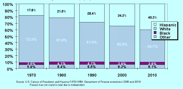
A major constraint regarding this issue is a lack of available research and data. DPR's 1993 Recreation Plan states that recreational needs change with increasing ethnic diversity, in part due to different cultural values and uses.[63] Studies also indicate that additional steps, other than simply providing the physical access, need to be taken to ensure access for all groups of people; these steps include providing transit services from inland areas to the coast, addressing the potential lack of familiarity of coastal recreation opportunities, and ensuring that opportunities are relevant to the users and that facilities can accommodate different ways of use (for example, ensuring clusters of picnic tables for large groups). [64],[65],[66],[67] However, due to a lack of information and long-range planning, information on whether ethnic groups have differing needs, and if so, what those needs are, is not available. Therefore, it is difficult to assess if the current recreation and access system is responsive to the needs of the population.
Meeting the needs of all potential users is dependent on determining who those users are, what types of facilities are wanted, and what barriers which prevent or hinder access. As a first step to addressing this issue, ReCAP sought to do a comprehensive survey to determine what types of access and facilities were wanted, and what, if anything, hinders access to the coast. In order to obtain the necessary information, the survey needs to reach those groups of people who do not currently use coastal access sites. A general population survey would reach not only existing users of coastal access to determine what is not meeting their needs, but also those groups who do not use access sites. However, this objective quickly became infeasible, due to the time and cost involved. To obtain additional information on barriers to use of coastal access sites, ReCAP contacted representatives of community organizations. ReCAP sent surveys to 18 representatives and received seven responses. All seven respondents indicated that access to coastal recreation opportunities was "very important". The main barriers to use of sites were: inadequate parking/lack of access to sites, fees, and a lack of information about sites. The majority of respondents indicated a need for better transit to the coast, additional parking, and additional facilities. The facilities cited as being necessary included improved access for handicapped users, facilities for groups, picnic facilities, and better diving access. The need for better maintenance of sites was also noted.
In spite of limited quantitative data, some qualitative evidence suggests that cumulative impacts are occurring to public access due to impacts on a number of variables other than physical supply. These variables include impacts to site quality, parking, and restrictions on use. In a number of cases, the existing framework of coastal access management through individual permits and LCPs does not adequately address these issues. Developing beach management plans and regional access plans may offer a more effective framework for addressing cumulative impacts to some factors of public coastal access.
As discussed previously, the Coastal Act requires protection of public coastal access opportunities. Regulatory review of new development proposals seeks to ensure that where development proposals will lead to negative impacts on access, those impacts are mitigated to protect access opportunities. While this review is generally effective in mitigating the loss of physical supply at specific sites, evidence indicates that cumulative impacts are occurring to overall site quality and accessibility to sites. Many aspects of ensuring public access are difficult to deal with through regulation of individual projects, as much of access planning requires coordination among agencies and departments. Further, since many of the impacts to these factors come from an overall increase in use of, and demand for, the resource, impacts may not be attributable to specific development projects; therefore, addressing impacts to these factors of access through mitigation measures on new development is difficult.
The LCPs generally focus on ensuring the physical supply of access by identifying access sites available at the time of certification within that jurisdiction. Many LCPs also identify where access dedications should be required for new development in order to protect access opportunities. However, as discussed under Access Problem #1, it is becoming more difficult to require such mitigation. In addition, many of the access sections of LCPs have not been updated since their preparation in the late 1970s and early 1980s. Although the LCPs are effective planning tools for guiding the protection and provision of access and recreation areas in general, in order to address many of the cumulative impacts to access, they need to expand to provide guidance to daily management of access sites. The policies of an LCP generally are implemented through review of a development proposal, and are therefore not generally aimed at day-to-day management of beaches. Few access components have policies or mechanisms to address issues rising from increasing use, and do not respond to changing situations, such as changing priorities for access locations or emerging demands for new or different facilities.
Because LCPs are developed for individual political jurisdictions, the pilot area LCPs do not address regional issues, particularly the distribution of access, the prioritization of facility development throughout a region, the availability of a diversity of recreational experiences, and regional transportation for access. Ensuring that access is provided throughout a region and that access improvements are placed where the demand is greatest is difficult under a program implemented through a project-by-project review and mitigation of site impacts.[68] Further, since use of the resource is not limited to users from a single jurisdiction, and the resource itself crosses jurisdictions, many of the issues involved with providing for and managing access also span jurisdictions. For example, in a number of cases in the pilot region, a stretch of beach is governed by different management entities where a beach is divided by political jurisdictions. In the City of Santa Cruz, the beach in front of the Santa Cruz Harbor is managed by the Port District, while immediately adjacent, DPR manages Twin Lakes State Beach. Although the beach between New Brighton State Beach in Santa Cruz County and Moss Landing State Beach in Monterey County is essentially an unbroken stretch of beach, it is managed by several different entities, including DPR, private owners, and the two counties.
In order to address the cumulative impacts to public access that are not being fully addressed through the current regulatory framework, different planning mechanisms may be more effective; developing management plans will provide guidance for recreational departments and ensure that daily management carries out the broader objectives of the Coastal Act and LCPs. Regional and site specific management plans can help address the cumulative impacts to those management issues that single LCPs and project-by-project review of development in the region cannot. Management plans could also incorporate some of ReCAP's other access recommendations and can provide a tool to address the conflicts between access and sensitive resources, including wetlands.
Many of the cumulative impacts to access result from an overall increase in use of beach areas. Other impacts result because of increasing trends that LCPs in the pilot region do not currently address, such as beach curfews and fees, and other impacts result from competing objectives within departments of a local government or between local governments.
One of the basic objectives an access management plan can address is mediating among a wide range of use conflicts. As use of sites continues to grow, and congestion at sites continues, the problems with competing uses at a site also increase. Without addressing these conflicts, the perceived availability of access and the quality of the recreational experience is affected. One example of a conflict in use affecting site quality centers around alcohol use at beaches. When Santa Cruz City imposed a ban on alcohol in the mid 1980s at Cowell Beach and Main Beach, law enforcement problems declined, improving the overall quality of the recreational experience.[69] As a result, family use of these beaches increased. However, undesirable activities and resulting impacts on site quality may have moved to unregulated beaches. A similar situation was seen when dogs were banned from some beaches. In order to avoid impacts from simply being transferred from beach to beach, regional management plans can establish which beaches are appropriate for what uses and ensure that site quality, overall recreation quality, and a diversity of experiences is maintained for the maximum users.
Also evident in the pilot region are other examples of impacts to site quality. For example, clean dredge spoils from Santa Cruz Harbor are often placed directly on Twin Lakes State Beach. Dredging operations, while helping to maximize boating opportunities and safety in the harbor, also can have significant impacts on beach access opportunities: stretches of beach are closed while the dredging occurs, and spoils emit unpleasant odors and attract large number of seagulls; thus the area is generally unattractive to beach users. However, it is important to ensure that the dredged sand remains in the shoreline system to maintain area beaches. The mitigation measures required for the Santa Cruz Harbor dredging provide examples of how to mitigate impacts and ensure maximum access: conditions require that spoils be placed during times of low recreational use and must be graded onto the beach.[70]
Another example of impacts to site quality occur from polluted runoff draining onto beaches, as occurs from Schwan Lagoon to Twin Lakes State Beach and from Neary Lagoon to Cowell Beach. Concern over, and reports of, degraded water quality at some sites in the pilot region are increasing; however, it is unclear if these reports are due to increased pollution, better monitoring, increased awareness and publicity, or a combination of these factors.[71],[72] Regardless, beach closures throughout the region impact the availability of public access. A degraded access site, or one that is perceived to be unsuitable for use, may reduce the desire of people to use the site, reducing the actual opportunities available to the public. The loss of opportunities at these sites may in turn lead to increasing use and congestion at other sites. A site management plan can be instrumental in assuring these types of issues are addressed in ways that protect beach access.
A number of cumulative impacts also result from a trend of increasing restrictions on access opportunities, including growing use of beach curfews and new and/or increased fees. In the ReCAP area, approximately 30% of the access sites ReCAP identified restrict hours.[73] Although ReCAP does not have historic data detailing when restrictions on hours were imposed, or when they changed, the trend of limited hours seems to be more prevalent in recent years: for example, after DPR imposed a curfew at Twin Lakes State Beach in the Live Oak area of Santa Cruz, the County supervisors imposed a curfew at their adjoining beaches. Data in 1981 indicates that at that time few beach areas restricted hours of use.[74] As the imposition of curfews spreads, access opportunities are lost not only at the specific beaches, but at a wider, regional area. One example of the loss of access opportunities is the inability of surfers, fishermen and other users to reach sites early in the morning.[75]
The imposition of fees is another trend that can cause significant changes in use of sites and adjoining uplands. Review of use data for DPR units in the pilot region cannot specifically correlate a change in use with the imposition of fees, particularly as many other factors may affect the use of a site.[76] However, staff observation indicates significant changes in use at several State Beaches since fees were imposed.[77] Moss Landing State Beach has provided historic access for sport fishing; after DPR imposed a day use fee, staff observed a significant decline in use of the Park by fishermen. At the same time, the number of sport fishermen using the South Harbor at Moss Landing and the Moss Landing Wildlife Area increased. This displacement in use has led to secondary impacts at these other sites: the South Harbor area has no facilities to support the increase in use by fishermen, leading to conflicts with parking and operation of the commercial harbor. Use at the Moss Landing Wildlife Area has led to resource impacts.
A second example of impacts from fees is observed at Palm Beach State Park.[78] Since DPR imposed fees at Palm Beach, staff observed increased parking along the side of the road. This trend raises not only safety concerns, but, since the roads border wetlands, result in resource impacts to these wetlands. Further, the fees may restrict lower-income users, particularly for fishing.
Intra- and inter-jurisdictional conflicts can also lead to cumulative impacts to access. Occasionally, an action taken by one department within a government contradicts the coastal access and recreation goals of another department. For example, staff observation in the ReCAP area indicates that in a number of areas, when residents perceive congestion due to beach use, they call the local public works departments and ask for "No Parking" signs to be installed or for curbs to be painted red; staff has observed this in the Live Oak and south County areas of Santa Cruz.[79] However, it appears that the public works departments do not always coordinate with the other departments responsible for maintaining public access to ensure that public access will not be compromised. In many areas, street parking is vital to ensure public access to the coast.
Different departments within a local government may also have competing objectives. When planning is undertaken in different departments, those competing objectives are difficult to correlate and require coordination. At Neary Lagoon and the San Lorenzo River Mouth, the City of Santa Cruz must manage both recreation/habitat values and ensure neighboring property against flooding. However, actions taken for either objective can affect the other.[80] A management plan can help resolve potential conflicts between such objectives.
Another example of such inter-jurisdictional conflicts occurs when interpreting some of the general policies in LCPs. For example, the Commission and City of Santa Cruz interpret policies regulating what development can occur on the beach differently.[81] A management plan can help ensure consistent application of policies and ensure that development on and adjacent to beach areas does not negatively affect access.
Since different issues relate to different geographic scales, different management plans should be developed for both individual access sites that are experiencing cumulative impacts and for a region. Management plans designed for the site level should address use numbers, user conflicts, upland support at the sites, habitat concerns at the site, and operation and maintenance. A beach management plan should also include procedures for coordinating intra-jurisdictional actions to ensure that actions from one department do not counter another department's access objectives.
Regional management plans should address overall parking availability and transit; habitat issues; priorities and distribution for access and support facilities, with an objective of providing a diversity of recreational experiences (i.e. urban, developed beaches versus rural, solitary beaches); and assuring that access priorities meet demand. Such regional plans should also establish priorities for opening and accepting offers to dedicate new access. Since many times adjacent beaches are managed by different entities, a regional management plan should also address interjurisdictional actions and include measures to minimize the effects of one action on another area.
Due to limited existing data, management plans should also develop mechanisms to track and monitor the data necessary to improve the provision of public access. This data include: use figures; the amount, type, and location of support facilities; change in facilities; ongoing maintenance; water quality; fees and limited hours; user needs; and sensitive species. This information is necessary to evaluate the extent to which cumulative impacts are occurring and the extent that those impacts are affecting use of sites. Currently, even basic information such as the number of users to a site was obtainable only for State Park units and for the main beach in Santa Cruz City. Use data provides the foundation for understanding access use and demand, determining whether increases in facilities match demand for them, and determining cumulative impacts to the resource. More accurate data will help develop more responsive policies.
In a number of cases, a management plan can be developed by supplementing an existing plan or process to incorporate the issues discussed above. For example, DPR has developed General Plans for each of the State Parks in the region; these plans can be updated to include management measures to address cumulative impacts. Current regional planning efforts may also be able to address some of the issues in a regional management plan. As discussed in Access Problem #4, Santa Cruz County is currently undertaking a regional transportation planning effort. By working with the County on this and other regional transportation efforts, such as congestion management plans, the issue of a regional transportation network for beach access can be incorporated. The development of the Monterey Bay National Sanctuary also provides opportunities to address access management through the coordination of coastal planning and management authorities in the region.
While development of a beach management plan or a regional management plan will provide the most comprehensive mechanisms for dealing with multiple sources of cumulative impacts, other mechanisms may be sufficient in cases where cumulative impacts are limited to a specific issue. In these cases, tools such as Memorandums of Agreement between the Commission and local government or between departments within a local government may be able to address the problem.
ENDNOTES
![]() Return to previous chapter,
Chapter 3: Coastal Hazards.
Return to previous chapter,
Chapter 3: Coastal Hazards.
![]() Go to next chapter, Chapter 5: Wetlands.
Go to next chapter, Chapter 5: Wetlands.
![]() Return to ReCap Pilot
Project...Monterey Bay Region Table of Contents
Return to ReCap Pilot
Project...Monterey Bay Region Table of Contents
![]() Return to California Coastal Commission Home Page
Return to California Coastal Commission Home Page