
One of the key issues in assessing public access is determining if improvements are keeping pace with population growth, use, and/or development in the area. In order to undertake this analysis, ReCAP needed to quantify the improvements in access and compare them with growth in the region. To do so, ReCAP identified all vertical access points in the region existing in 1993 and areas of the coast that could support access but currently do not; areas with steep bluffs dropping directly into the sea were not included since access to the shore would be infeasible.[1] ReCAP then rated these areas according to the availability of access, based on the scale below, for a base year of 1981 and for 1993.[2]
Access Ratings:
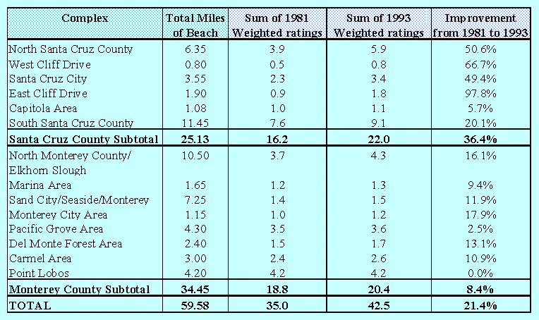
Table B-1 shows the results of the analysis. A weighted rating was calculated for each site by multiplying the site's rating by the miles of beach at that site. A total was obtained for each complex by summing the weighted ratings of all the sites in that complex. Except for Point Lobos, which already provided excellent public access in 1981, every complex in the region improved the supply of vertical access.
Table B-1: Comparative Improvement in Physical Access to the Coast in the ReCAP Region
To relate these improvements to the increase in demand for access, ReCAP needed to compare the areas having increased use with improvements to access in those areas. Since the data for actual use of sites is limited, ReCAP used both population increases and the amount of new development for the various areas in the ReCAP region as indicators of increasing use. While these figures do not indicate actual use of coastal access sites, they do indicate areas of growth; it is likely that an increase in population and development corresponds to an overall increase in use of the area, especially in areas known for high coastal recreation like the pilot region. In fact, since an increase in tourism is not considered, the actual increase in use will likely be greater than that estimated from population growth in the region and development increases.
Table B-2 shows the population growth for the coastal zone cities in the ReCAP region, and for each county as a whole. While Table B-1 and Table B-2[3] show a general correlation between areas with population increase and improved access, a few exceptions are evident. While Watsonville grew significantly since 1980, the city does not physically border the coast, and therefore cannot improve its coastal access. However, the increased population probably places additional demands on coastal access sites near Watsonville. Although many areas within Monterey County significantly improved coastal access, the overall improvement falls well below the population growth for the County, particularly due to growth in the Marina area. The City of Marina did however develop two parks: Locke Paddon and KIDD pond. Although they do not provide coastal access, the parks do provide recreational opportunities. In addition, although the City of Capitola grew in population at a fairly high rate, its improvements to access supply are minimal. However, Capitola has historically provided significant amounts of beach access; the improvements undertaken between 1981 and 1993 appear to have maximized physical access in the City to the greatest extent possible.
Table B-2: Population Growth in ReCAP Cities, 1980-1990
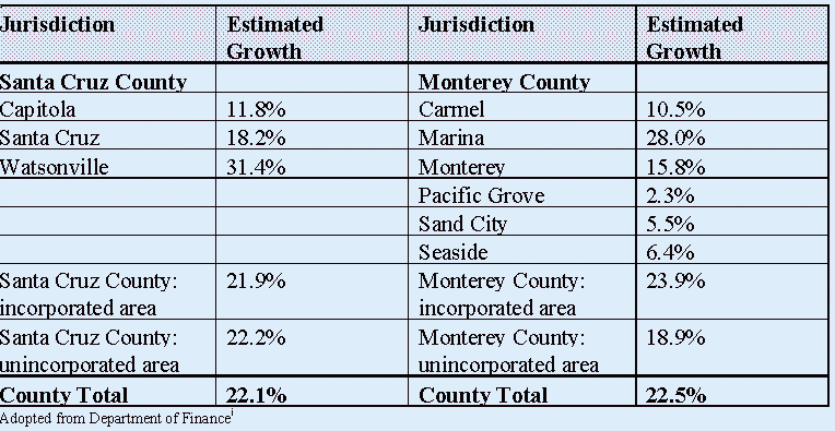
Adopted from Department of Finance[4]
The ReCAP region has experienced significant development since 1981. Much of this development has probably contributed to the overall increase in recreation use. Review of aerial photos (1978 and 1993) shows major areas of development in Santa Cruz County south of Capitola through the La Selva area, along with infilling in the Live Oak area. In Monterey County, significant development was seen in the Marina area. While not all of this development may be in the coastal zone, and most is not directly adjacent to the beach, it likely leads to increased demand for access. Improvements to access in these areas include several stairways in the Live Oak area, significant improvements at Santa Cruz harbor, two new access points in southern Santa Cruz County, and the development of two parks in Marina.
Many of the areas that currently do not meet the access standards identified in LCPs have had significant amounts of development nearby. However, many of these areas cannot support additional vertical access, due to the geography of the site. These areas include West Cliff Drive, Opal Cliffs Drive, and the southern end of Capitola Beach to New Brighton Beach. In addition, areas near the Hopkins and Long Marine labs and north of Marina dunes area probably could not support access due to research needs and conflicts with habitat protection.
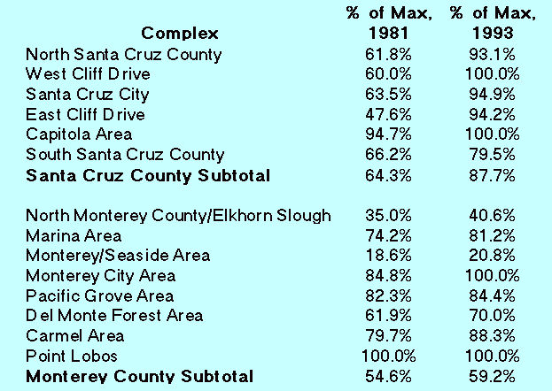
To assess the amount of future vertical access feasible, ReCAP compared the ratings calculated in Table B-1 to a theoretically possible rating of 1 for each access site for 1981 and 1993. Totals for each complex were then determined (see Table B-3). These calculations show the extent that access could still improve in each complex. The percent of maximum does not indicate the percent of coastline in the complex with available access, but represents how much additional access can physically be provided. For example, West Cliff Drive shows maximum physical access is now available. While there are stretches of the coast in this complex without vertical access, those areas cannot physically support access due to physical constraints. Where access can be provided, it exists and meets the standards of the local coastal plan; therefore the complex provides access at 100% of the maximum possible. This analysis suggests that much of Santa Cruz County is at, or near, its capacity to provide physical access to the shore.
Table B-3: Percent of Maximum Physical Accessibility, 1981 and 1993
ENDNOTES
![]() Return to Appendix A: Changes in Access Opportunities in the ReCap Region.
Return to Appendix A: Changes in Access Opportunities in the ReCap Region.
![]() Go to Chapter 4: Public Access.
Go to Chapter 4: Public Access.
![]() Go to the ReCap Pilot
Project...Monterey Bay Region Table of Contents
Go to the ReCap Pilot
Project...Monterey Bay Region Table of Contents
![]() Go to the to California Coastal Commission Home Page
Go to the to California Coastal Commission Home Page