
This chapter examines both wetland resources and the institutional framework used to determine how these resources are protected and managed. The historic, current and projected status of wetland morphology (acreage, fragmentation, and habitat), physicochemical processes (hydrology and water quality), and biodiversity are presented. Institutional analysis focuses primarily on the California Coastal Management Program (CCMP), as implemented by the Coastal Commission and local governments, and secondarily on other federal and State statutes governing wetlands.
Wetland resources within the ReCAP region have suffered significant adverse impacts over time. Results from this project generally indicate that:
A framework for regulating adverse affects to natural resources, consisting of the California Coastal Act, the Clean Water Act, and the California Environmental Quality Act, among others, was institutionalized in the early 1970's. By and large, the resulting regulations have prevented significant additional adverse wetland impacts from new development. However, these laws contain several exemptions that limit their universal application, especially for pre-existing land use activities. Various implementation deficiencies also limit the effectiveness of these laws. Limitations on wetland fill are most stringent, while limitations on other types of activities in wetlands (e.g., vegetation removal or draining), and limitations on detrimental development adjacent to wetlands (such as those causing abnormal erosion) are less stringent. A lack of readily available information further limits the ability of regulatory programs to address cumulative adverse impacts to wetlands.
A variety of approaches are possible to address the existing procedural deficiencies. For instance, changes in the way some regulations are implemented to improve consistency would benefit both the regulatory agencies and the regulated community. Additionally, numerous wetland management plans have been and are being prepared to address current wetland issues. Recent and pending federal legislation to control nonpoint source pollution promises new mechanisms at the watershed level to further reduce wetland degradation.[1] Notably, this new generation of comprehensive wetland- and watershed-based planning and regulation, and the resultant information generated, has occurred since the project area's local coastal programs were originally adopted. The challenge faced by the Commission and local governments is to incorporate these new approaches into the CCMP, while continuing to support currently successful protective efforts.
ReCAP's analyses show that in order to more fully address cumulative impacts, wetland issues should be addressed in a comprehensive, watershed-based framework, which is contrary to the typically fragmented practices of the past. The primary recommendation is to establish a regional framework to set priorities, coordinate, provide technical assistance, and otherwise guide preparation and implementation of wetland and watershed management plans (see Wetlands Problem #7). The apparent best course of action is to capitalize on the recently-initiated Monterey Bay National Marine Sanctuary's Integrated Coastal Management (ICM) process, which is currently working to complete a water quality protection program. It is within the ICM framework that specific watershed and wetland management planning should continue, so as to address local concerns from a regional perspective. This chapter recommends some guidelines for preparing wetland management plans and processes for integrating these plans into the CCMP.
In conjunction with this overall recommendation, ReCAP recommends specific improvements in the following categories:
ReCAP's analyses represent only a first level of recommended improvements. As additional information and recommendations are generated, they are expected to lead to further refinements of the existing local coastal programs and other elements of the CCMP. At the same time, implementation of wetland and watershed management plans should lead to enhancement of the region's degraded wetlands. With respect to wetlands, the CCMP must be improved in a manner that leads to more comprehensive management, of which regulation of new development is only one component.
The next section of this chapter presents as background information the policy framework under which wetlands are regulated, summarizes the status and trends of wetland resources in the region, and describes the analytical approach used to assess cumulative impacts to wetlands. Finally, this chapter describes seven problems identified through the cumulative assessment, including a discussion of the apparent causes of the problems, projections for their continuance and resolution, and specific recommendations for correction or improvement. The problems are:
Wetlands are a significant, but severely impacted, natural resource within California. Only since the late 1960's have wetlands engaged the attention of individuals from a range of disciplines who endeavor to understand their variety and complexity.[2] Recent but intense interest in wetlands is due largely to their role in aquatic and terrestrial ecosystems, and our changing perceptions of them. Humans have come to understand how important wetlands are to the existence of numerous plants and animals, as well as the many functions they perform (e.g., flood control, ground water recharge, and maintenance of water quality) that are important to our quality of life.
This section provides a description of three elements that play an important role in assessing the cumulative impacts to wetlands within the ReCAP region: (1) the existing policy framework; (2) the current status of wetland resources; and (3) the analytical framework used for this assessment. Each of these elements is described separately, but together form the foundation for ReCAP's identification and analysis of cumulative impacts to wetlands.
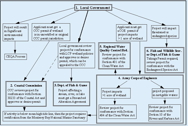
Currently, numerous federal, State, and local agencies administer and enforce a myriad of regulations that limit and control the development and alteration of wetlands in California.[3] (For an example of the regulatory framework for wetlands in the ReCAP pilot area, see Figure 5-1.) Although a few statutes and directives are specific to wetlands, most of the regulatory influence over wetlands occurs indirectly through management or regulation of water quality and quantity, fish and wildlife, endangered species habitat, water navigation, floodplain control, public trust, environmental land use regulations, and coastal resource conservation.[4] However, even with the complex array of existing regulations, California's wetlands do not receive equal protection. Although the federal regulations stipulated in the Clean Water Act (Section 404) and the River and Harbors Act (Section 10) apply to most of the wetlands within the State, only wetlands within San Francisco Bay and the coastal zone are afforded additional protection through specific State coastal program provisions.
Figure 5-1: Relationships Between Various Permits that May be Required for Development in a Wetland Occurring in the Coastal Zone[5]
The Coastal Commission is the lead State agency charged with the regulation of development in California's coastal zone.[6] The California Coastal Act is the document the Coastal Commission relies on for overall guidance and direction in fulfilling its charge. Sections 30230, 30231, 30233, 30236, and 30240 of the Coastal Act relate directly to the preservation and protection of wetlands and other environmentally sensitive areas. The development and alteration of wetlands in the coastal zone, however, are primarily regulated by Section 30233(a) of the Coastal Act. Among other things, Section 30233(a) lists the types of development for which diking, filling, or dredging may be permitted in open coastal waters, estuaries, lakes, and wetlands.[7] This section also stipulates the criteria under which development is permitted (i.e., least environmentally damaging feasible alternative and provision of adequate and feasible mitigation). In addition to the specific provisions of the Coastal Act, the Coastal Commission has adopted the Statewide Interpretive Guidelines for Wetlands and Other Wet Environmentally Sensitive Habitat Areas (1981). These guidelines contain technical definitions for wetlands and riparian areas, discuss conditions for permitting development in these areas, and provide information pertaining to the maintenance and restoration of wetlands. The guidelines were
Figure 5-2: Location of Wetlands in the ReCAP Pilot Area. Click here to view. Figure 5-2.
developed to assist the Coastal Commission, local governments, and the public in the application and interpretation of the Coastal Act and in the development of local coastal programs. Most recently, the Coastal Commission has produced a document entitled Procedural Guidance For The Review Of Wetland Projects In California's Coastal Zone (1994). This document describes a review process the Coastal Commission uses to evaluate proposed wetland development projects.
The California Coastal Act is designed to delegate to local governments much of the Coastal Commission's authority to regulate coastal development through the implementation of local coastal programs (LCPs). To become certified for use, the LCPs must, compared to the Coastal Act, provide equal or greater protection of coastal resources. With a certified LCP, a local government assumes authority for permitting certain types of development in specified areas of the coastal zone, including many of the wetlands in the ReCAP region.
Local governments with jurisdictions in the ReCAP pilot area ensure that their LCPs provide for the regulation of wetland development by identifying wetlands as "environmentally sensitive habitat areas" and, pursuant to Coastal Act Section 30240, limiting development to resource-dependent uses. The LCPs also contain specific language relating to the protection of wetlands within the jurisdiction. For example, the LCPs specify the width of buffer areas around wetlands (see discussion of buffer areas under Wetland Problem #2), specify erosion control measures to prevent excessive amounts of sediment from entering wetlands, and specify management strategies for particular wetlands.[8] Because of the shared responsibility for management of wetlands, program improvements need to be implemented in a coordinated fashion by the Commission and local governments.
The ReCAP project area contains a diverse array of wetlands. Coastal lagoons, large slough complexes, salt and freshwater marshes, lakes, and rivers all occur within the project area. Analysis completed as part of this project revealed 99 wetlands[9] within the project area (Figure 0-2, page 75), totaling approximately 6,200 acres. A review of aerial photographs from 1977, 1986, and 1993 suggests there has not been an appreciable change in total wetland acreage over the last 16 years.[10] Of the 99 wetlands identified in the project area, at least 16 have been placed under more protective status in the last 20 years. Comprehensive management plans have been prepared or are being prepared for at least 24 of the area's wetlands. Restoration projects have been undertaken for at least 32 of the area's wetlands.
It is important to realize, however, that wetland acreage is not the sole determinant of the condition of wetland resources. The quality of a wetland is more accurately determined by acreage and functional capacity. California's coastal wetlands serve a number of important functions such as the provision of habitat for native wildlife, water purification, and flood control. The value of these functions will vary depending on the wetland size, its location in the watershed, and the surrounding land use.
Both natural and anthropogenic processes have historically affected the quality of wetlands in the ReCAP project area. Natural changes involve processes still occurring today: seasonal berm formation at the mouths of coastal lagoons, changes in freshwater inputs due to droughts and floods, and earthquakes. Human-induced changes have involved activities related to agricultural and urban development. Over the previous century, development projects such as the damming of rivers, construction of transportation corridors, and major urban and agricultural development have all diminished the quantity and quality of wetland habitat through the degradation of wetland hydrology, water quality, and direct habitat loss. More recently, however, wetland habitat has been most affected by the lingering effects of earlier development (e.g., point and nonpoint source pollution, chronic reductions in the amount of water reaching wetlands, and the loss of adjacent buffer areas). Although still apparent, the rate at which wetland habitat, hydrology, water quality, sedimentation rates, and biodiversity are adversely impacted appears to have declined since inception of the Coastal Act. On the other hand, there are few examples of positive change from an ecological perspective. Thus, the challenge is not simply to halt, but to reverse the historic adverse impacts, as enhancement and restoration are also Coastal Act objectives (Section 30001.5).
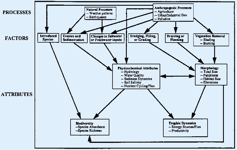
Conceptually, a number of factors have the potential of affecting a wetland through changes to one or more of the physical, chemical, or biological attributes (Figure 5-3). The conceptual diagram below illustrates the key attributes of a wetland, the various factors that could impact those attributes, and the principal processes that exert influence over the factors. The connecting arrows depict the pathways by which the processes can influence the various attributes. For example, urban development (an anthropogenic process) may enhance the establishment of introduced species, which can adversely impact wetland biodiversity. In addition, many of the pathways are interconnected. For example, a drought will lead to reduced freshwater inputs, which will affect wetland hydrology (physicochemical), which can ultimately affect both the size (morphology) and species abundance (biodiversity).
Figure 5-3: Original Conceptual Model Showing the Relationships Between Processes, Factors and Attributes in Wetlands
Because of their complexity, the cumulative impacts to wetland resources in the ReCAP project area were investigated through separate study of three key attributes: (1) morphology; (2) physicochemical processes; and (3) biodiversity. Although trophic dynamics was also considered a key attribute, it was not included in this analysis due to a lack of valid information.[11] Based on analyses of the various wetland attributes, this chapter describes, as problem statements, the various sources of impacts, and recommends procedural or policy changes to resolve or reduce the identified problem. This chapter also examines wetland regulatory concerns and comprehensive management issues in an attempt to determine strategies for long-term effective management of cumulative impacts. In all cases, the analyses attempt to answer three basic questions: (1) what has happened; (2) why has it happened; and (3) what will happen if past trends continue. The analyses generally consider two time frames: (1) the Coastal Act period (1973 -1993, emphasizing the second decade, 1983-93, when many of the region's local coastal programs were certified); and (2) to a lesser extent, the pre-Coastal Act period (1972 and earlier).
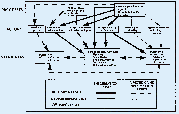
Although separate analyses were completed for the various attributes, wetlands are not isolated systems. Interactions among wetlands and the surrounding landscape occur continually by way of water, air, and the organisms that rely on them. Thus, impacts to one aspect of a wetland will affect other attributes as well as other wetlands. With this in mind, results of the analyses were also used to revise the conceptual model of wetland impacts (Figure 5-4). These revisions included refinement of the connections between sources of impacts (processes and factors) and the affected attributes. In addition, the connecting arrows were qualitatively weighted (e.g., high, medium, and low). This weighting provides an indication of the contribution various processes and factors made to documented changes in wetland attributes. The results show that anthropogenic processes had the largest cumulative effect on wetlands in the ReCAP project area, which manifest as changes in physicochemical and morphological attributes. Natural processes were also found to affect the wetlands over the last ten years, albeit to a lesser extent, through changes in saltwater or freshwater inputs. There were several indications that wetland biodiversity has been adversely affected, but the available information was limited and did not provide evidence for the magnitude or sources of the impacts.
Figure 5-4: Revised Conceptual Model Showing the Relationships Between Processes, Factors and Attributes in Wetlands
Because wetlands are not isolated systems, assessments that evaluate wetland impacts as isolated occurrences provide an incomplete picture. There is clearly a need to take a landscape approach to protecting and managing wetlands. Resource and regulatory agencies must think about wetlands as part of a bigger system, as integral components of the watershed. Finally, these agencies need to include humans within that bigger system, not only as a source of impacts, but also as the potential solution to the cumulative impacts humans have created.[12]
The amount of wetland acreage in the Monterey Bay pilot region has greatly decreased over the last century and wetlands have become more fragmented, due primarily to human impacts. Neither the CCMP nor any other program comprehensively addresses historic loss. Recent and potential permitted and unpermitted development have resulted in and may continue, absent some regulatory improvement, to result in some additional wetland acreage loss.
The disappearance of our nation's wetlands -- an estimated 90% loss in California -- is a major environmental concern.[13] So is the resulting fragmentation: historic wetland connections have been severed and distances between wetlands have increased. In the project area, wetland loss and fragmentation are historic problems that persist with no comprehensive, accepted remedy. In addition, alterations to existing wetlands have resulted in habitat changes, some of which have been adverse.[14]
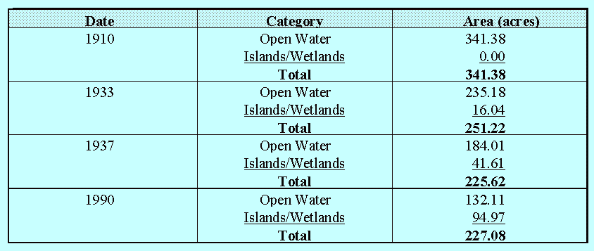
Large portions of the pilot area's historic wetlands disappeared in the century prior to environmentally-based regulation (pre-1970's). Although the total loss has not been quantified, some examples illustrate the magnitude.[15] Table 5-1 shows over 114 acres (33%) lost at Salinas River Lagoon.[16] Neary Lagoon's size diminished 60% from 75 to 30 acres.[17] Wilder Lagoon shrunk by almost 70% from 49 to 15 acres as Figure 5-5 shows.[18] In all cases, human activities, especially diking, draining and filling for agriculture, were largely responsible.[19]
Table 5-1: Historical Areal Changes in Salinas River Lagoon Habitat
Figure
5-5: Wetland delineation of Wilder Pilot Area based on present
vegetation, soil, and standing water; and likely historical wetland
area Fragmentation.
Click here to view Figure 5.5.
This historic loss of wetland acreage also resulted in the fragmentation of wetlands.[20] Fragmentation refers to the severing of physical and ecological linkages between wetlands. Fragmentation affects wetlands adversely by reducing water circulation and limiting the migration of individuals among previously continuous populations of plants and animals. Small, isolated populations are much more susceptible to natural and human-induced stresses and have more difficulty recovering from such stresses than large, contiguous populations. Fragmentation may, therefore, be closely linked with declines in biodiversity. Within the ReCAP region, this is seen most prominently in southern Santa Cruz and northern Monterey Counties. For example, within the coastal zone north of the Salinas River and south of Moss Landing, some wetland areas disappeared altogether,[21] while the two remaining wetlands (Old Salinas River Channel and Tembladero Slough) were reduced to drainage channels.[22] The historic connection between the Salinas River and the Pajaro River north of Moss Landing was lost. The alteration of Upper Watsonville Slough (which connected to the Pajaro River mouth via lower Watsonville Slough) resulted in the severing of historic connections with Harkins, Hanson, Gallighan, and West Branch Struve Sloughs.[23]
Just outside the coastal zone of Monterey Bay a significant example of wetland fragmentation occurred over time along the northern corridor of the Salinas River. A chain of nine lakes spaced over a distance of approximately ten miles has mostly disappeared, due to agricultural activities; only one lake remains.[24]
Habitat Change
The physical character of some of the remaining wetlands has also changed over time. For example, Schwann Lagoon was transformed from a coastal lagoon into a freshwater lake when its connection with the sea was obstructed by road construction. Open water habitat areas in Bonita Lagoon, Carmel River Lagoon, and Salinas River Lagoon have gradually filled in and become vegetated (see Table 5-1 for one example). Conversely, harbor construction has turned portions of the vegetated marsh habitats in Arana Gulch (Woods Lagoon) and the Old Salinas River Channel into open deepwater habitats. The construction of Moss Landing Harbor has been linked to excessive channel erosion, resulting in the loss of intertidal marsh habitat in Elkhorn Slough.[25]
Not all habitat changes are bad. Sometimes such changes are done intentionally as part of wetland restoration efforts. However, most of the unplanned habitat changes (i.e., those that occurred as unintentional consequences of other activities) are likely to result in negative impacts. (For additional details and examples, see endnote #14.)
Continued development pressures coupled with gaps in the regulatory process suggest that further wetland losses, fragmentation, and adverse habitat changes are possible.
The vast changes to wetlands occurred in an era when environmental regulation was absent and economic development of wetlands was more highly valued than their natural state. This changed in the early 1970's with the advent of the California Coastal Act, the California Environment Quality Act (CEQA) and its federal counterpart the National Environmental Policy Act (NEPA), and with the consideration of environmental factors in implementing the Clean Water Act.[26] Coastal Act Section 30233c, for example, prohibits most development in wetlands, except those of a resource-dependent nature that lack less environmentally damaging feasible alternatives, and for which adequate mitigation exists.[27]
As a result of protective legislation, few permits issued in the study area since 1973 have allowed wetland fill; those that have by-and-large required at least equivalent compensation (i.e., required an equal or greater acreage of wetland to be restored or created from dry land elsewhere).[28] The Coastal Act's authority has allowed Commission staff to participate in discussions about potential projects before permit applications are submitted and thereby encourage alternatives to wetland fills. In the few instances where applicants persisted with insupportable fill projects, the Commission has denied the request. Such instances include urban development in Jessie Street marsh, wastewater plant expansion into Neary Lagoon, and road fill in Elkhorn Slough.[29]
In spite of existing regulations, some direct loss of wetland area has occurred over the last twenty years at Moro Cojo Slough, Elkhorn Slough, McCluskey Slough, and Watsonville Slough, due to agriculture activities, and at Spanish Bay due to urban activities.[30] At least temporary losses have occurred at Neary Lagoon, Majors Creek, and Lower Watsonville Slough, where after-the-fact enforcement actions have been initiated to remediate unpermitted fills.[31]
That these instances have occurred, along with other factors, suggest that additional activities resulting in wetland loss will be attempted in the future. These other factors include known pending projects,[32] some unauthorized activities,[33] potentially allowable wetland uses, disputes about what is really a wetland, no guarantees of mitigation success, and private and public ownership of wetlands not in preserve status. In addition, gaps in the CCMP regulatory process can allow incursions into wetlands to occur.[34] These gaps include agricultural exemptions, inconsistent enforcement and condition compliance, inconsistent wetland delineation methods, and permitted uses without guaranteed compensatory mechanisms.
Agricultural Exemptions
The list of allowable wetland uses in Coastal Act Section 30233a does not include agriculture. Most LCPs place wetlands under a resource protection category and do not explicitly show agriculture as a permitted use. However, not all agricultural activities qualify as new "development," and therefore do not require a coastal permit. According to the Commission's Statewide Interpretive Guidelines (1981),
When wetlands are seasonally farmed, the continued use of agriculture is allowed. Expanding farming operations into non-farmed wetlands by diking or otherwise altering the functional capacity of the wetland is not permitted. Farm-related structures (including barns, sheds, and farm-owner occupied housing) necessary for the continuance of the existing operation of the farmed wetlands may be located on an existing farmed wetland parcel, only if no alternative upland location is available for such purpose and the structures are sited and designed to minimize the adverse environmental effects on the farmed wetland. Clustering will be required.[35]
The Coastal Commission has considered that expanding cultivation or grazing into a wetland that has not been recently farmed, even if no diking or grading is involved, is "development". However, others might not share that interpretation based on Section 30106 of the Coastal Act,[36] which states in part:
Development means, on land, in or under water, the placement or erection of any solid material or structure; discharge or disposal of any dredged material or any gaseous, liquid, solid, or thermal waste; grading, removing, dredging, mining, or extraction of any materials; change in the density or intensity of use of land, and the removal or harvesting of major vegetation other than for agricultural purposes...
The North Monterey County Land Use Plan is the only plan in the ReCAP region that has a broadened definition of development that includes some agricultural removal or harvesting of major vegetation, but not specifically wetland vegetation.[37]
The result of these regulatory limitations has been the continued cultivation of historic wetlands (especially in the Watsonville Slough complex), a few new (or reactivated) cultivated wetland areas, and expanded grazing in wetlands.[38] The vegetation removal exception may also have been interpreted by agricultural land owners to mean that diking, draining, and filling are allowed without a permit if the purpose of such activities is to allow the continuation of on-going agricultural activities (for example, diking to prevent a wetland from reclaiming part of a cultivated field at the end of a drought).
Condition Non-Compliance and Impediments to Enforcement
Chapter 9 of the Coastal Act provides for judicial review, enforcement, and penalties for violations. Most local coastal programs echo such provisions, and contain procedures for addressing violations on a local level.[39] Staffing limitations have required reliance on discovery by others and have resulted in highly variable follow-up. Lack of consistent reporting and computerized record keeping has further hindered compliance monitoring efforts. Even when enforcement commences, guaranteeing successful mitigation is problematic (see section on mitigation problems below).
The resulting unrectified incursions, discovered through ReCAP's aerial photography interpretation, include, for example, several acres of Moro Cojo Slough that have been diked and cultivated since 1977, and small areas at the margins of McCluskey Slough and Elkhorn Slough.[40] In cases where discovery has already led to enforcement actions being initiated, restoration has not always been achieved. For example, out of 14 required restoration plans, only eight have been formulated and six completed.[41] Unpermitted activities in wetlands represent net wetland acreage losses until restoration is completed.
In cases where wetland alterations are conditionally permitted, similar staffing and tracking limitations constrain the Commission's ability to assure condition compliance (e.g. successful mitigation). Without adequate staffing to conduct field inspections, it is often not known whether permitted losses are successfully mitigated. Unfortunately, limitations in the Commission's tracking and post-construction inspection system mean that there is a lack of sufficient evidence available to evaluate this concern. [42]
Inconsistent Delineation Methods
Coastal Act Section 30121 simply defines "wetlands" as "lands ... which may be covered periodically or permanently with shallow water and include saltwater marshes, freshwater marshes, open or closed brackish water marshes, swamps, mudflats and fens." According to the Coastal Commission's Interpretive Guidelines, the U.S. Fish and Wildlife Service's classification system (1979), commonly known as the Cowardin method,[43] is to serve as the guide for identifying wetlands. Local coastal programs contain the Coastal Act definition. However, only two out of ten LCPs in the ReCAP region reference the Cowardin method (or for that matter any particular delineation method).[44] Various other less encompassing methods have been and are performed for local and state agencies (typically through the CEQA process).[45] Recent wetland delineations are based on the U.S. Army Corps of Engineers' methodology for implementing the Clean Water Act, which itself has undergone changes in the past ten years.[46] Earlier EIRs and other documents often termed what would be "wetlands" under the Cowardin (and possibly the Corps) method as "drainage channels" or "riparian areas." Even the Coastal Commission's guidelines distinguish riparian areas as distinct from wetlands, a distinction not made by the Cowardin method.[47] Furthermore, Coastal Commission Interpretive Guidelines remain advisory. In fact, the Commission has substantial latitude to determine whether an area falls under the Coastal Act definition of "wetland".
The result of wetland delineation uncertainties has allowed some fills to escape Coastal Act Section 30233's requirements. For example, prior to development at Spanish Bay, which had previously been mined, drainage channels and ponds existed that would likely be classified as wetlands under the Cowardin method. However, EIRs and Coastal Commission findings described these features variously, and the Commission ultimately did not classify them as wetlands.[48] Commission staff explained that this was because they were unnatural, the results of water ponding in mined areas.[49] It appears that there was a net (permitted, but unstated) loss of approximately eight of these variously labeled wetland acres.[50]
Two other examples involved eight acres of "seasonally flooded grassland" at Neary Lagoon and about one-half acre of "man made degraded riparian channel" at Schwann Lagoon. Both were ultimately determined not to be "wetlands" by the Commission.[51] In these cases, project proponents (both public agencies: a city and a school district) offered biological opinions against the areas being "wetlands," while concerned citizens countered with pro-wetland biological determinations. Projects filling these areas were approved, without compensating mitigation in the case of Neary Lagoon.
Permitted Uses Without Guaranteed Compensatory Mitigation
Despite requiring compensatory mitigation for identified wetlands, the Coastal Act does not guarantee no net loss, especially of habitat value, because compensatory mitigation success is problematic at best.[52] Examples of the few restoration projects in the pilot area with monitoring tend to support this conclusion. Of two projects funded by and retrospectively analyzed by the Coastal Conservancy, one was a failure.[53] Also, the submitted reports for the Spanish Bay mitigation site, which has been monitored for five years, indicate general success of restoration. However, planted willows have not all survived, sediment has filled an area that now must be redredged, and unauthorized work has occurred.[54] At a mitigation site on the Old Salinas River channel, monitoring reports indicate that the plant communities are developing in a manner similar to that anticipated, with some non-native colonization and various revegetation rates.[55] Independent evaluation offers a more negative perspective, calling the project a mistake for removing an historic pickleweed marsh.[56]
A review of these and other monitoring reports shows continued oversight is necessary to discover problems and recommend corrections. Where staff training or availability is limited, mitigation success will be less assured. This review also suggests that although net wetland acreage may remain constant or increase if compensatory mitigation is successful, habitat differences may result and habitat value may be consequently reduced (see Endnote #14).
Thus, the more development permitted in wetlands, the greater the probability of some continued loss. Consequently, the more leeway in allowing development, the greater the probability of its occurrence. Out of 28 permitted projects involving wetland fill, four were for explicitly permitted uses under Section 30233a (boating and resource restoration) and seven were associated with urban development (which is not listed as a permitted use). The remainder were for public projects (flood control, roads, wastewater facilities) which in some cases may be considered incidental public services under 30233a.[57] Thus, there is a fair amount of discretion built into implementing this section. Local coastal programs have narrowed this discretion, generally limiting allowed development to resource-dependent uses.[58] Seven of these projects were permitted by local governments.
To the extent that riparian areas are not defined as "wetlands" for regulatory purposes (see delineation discussion), there is a higher risk of loss of this type of wetland. Although Section 30240 of the Coastal Act treating riparian areas as "environmentally sensitive habitats" could apply to such areas, the wetland mitigation standards in Section 30607.1 do not.[59] Thus riparian wetland areas may be especially at risk of being developed without adequate mitigation.
Initiatives to standardize delineation methods, achieve "no net loss" and guide restoration could help reduce future wetland loss. Tightening exemptions that allow wetland fill and increasing enforcement and education would provide additional help. Programs extending beyond regulation are also needed to restore and enhance historic wetlands.
Delineation
The Coastal Commission's recently published "Procedural Guidance for the Review of Wetland Projects in California's Coastal Zone" reiterates the Coastal Act's broad wetland definition, suggests the importance of riparian area protection, and emphasizes early involvement in the CEQA process.[60] Comments on CEQA documents could request that appropriate wetland delineations are made early on in the project review process. Incorporating these concepts into the local governments' local coastal program implementation would be a logical follow up.
Federal agencies have standardized wetland delineation methods for regulatory purposes, and California's Resources Agency is attempting to develop a single state definition.[61] Such standardization, followed up with a manual and training course, has the potential to ensure more consistent and complete delineations. However, if the standardized methodology does not account for all wetlands protected under the Coastal Act, as previous attempts did not, then the CCMP will not benefit from this course of action.
No Net Loss
Both Governor Wilson and President Clinton have issued wetland policies that include the goal of "No Net Loss" of wetland quantity or quality.[62] The California Department of Fish and Game also operates under "No Net Loss" directives, applying to habitat values as well as acreage.[63] Codifying the no-net loss principle at all levels of government and establishing guidelines for implementation is a logical next step.
Mitigation Guidance
The Coastal Commission's Procedural Guidance for the Review of Wetland Projects offers criteria aimed at increasing the success rate of compensatory wetland mitigation efforts.[64] Its forthcoming Procedural Guidance for Evaluation of Wetland Mitigation Projects is expected to provide more detailed information. Incorporating the results of these in both the Commission's and local government's practices may improve wetland management.
Regulatory Reform
Possible changes to the Coastal Act and local coastal programs to further restrict allowed wetland uses would reduce the number of potential projects that could cause wetland loss. Such changes could include tightening agricultural exemptions, more explicitly defining and interpreting the categories of permitted uses (e.g., "incidental public services" and "restoration activities"), possibly eliminating some categories of permitted uses, strengthening the criteria for restricting permitted uses, and/or limiting the kinds of wetlands where the uses are allowed. Such initiatives would have to be undertaken in a manner consistent with Coastal Act requirements concerning constitutionally protected rights of property owners.[65] Recent court cases suggest the advisability of examining non-regulatory as well as regulatory innovations to protect remaining wetlands and/or strengthen compensating mitigation requirements.[66] Further impetus comes from the delineation of more areas now as wetlands (usually during the development review process) that do not "look like" wetlands, but have the requisite characteristics.[67]
Wetland Restoration and Creation Programs
Certainly additional regulation will not result in the reappearance of lost wetlands. The Coastal Act supports restoration where feasible. Similarly, the LCPs all mention objectives to restore and increase wetland acreage. In 1983, the Legislature called for an increase by 50% of wetland habitat acreage by the year 2000.[68] Moreover, Governor Wilson's new wetland policy calls for a long-term net gain in the quantity and quality of wetland acreage, as does President Clinton's.[69]
One "new" wetland was created just prior to the establishment of the Coastal Act. As part of a major condominium project, the 3.8 acre Shorebirds Lagoon was constructed north of Pajaro River in an area that earlier was salt marsh.[70] Since establishment of the Coastal Act, major restoration projects have occurred only at Elkhorn Slough and adjacent Parsons Slough. One hundred seventy-five acres of grazing land has been converted back to wetlands.[71] These projects occurred on property owned by the Department of Fish and Game and were publicly funded.[72]
At the beginning of 1994, there were commitments to undertake the following projects:
This latter project is being undertaken by a non-profit group affiliated with Moss Landing Marine Laboratories (Watershed Ecology Outreach Program). WEOP's strategy is to first obtain landowner permission and then to remove agricultural uses and plant with wetland vegetation on as much historic wetland area as possible in southern Santa Cruz and northern Monterey Counties.
Continuing to follow and improve the implementation of existing regulations should help ensure that additional wetland loss does not occur. Even more assurance can be gained by undertaking a more specific planning process focusing on individual wetlands and their watersheds. A plan for a single or group of wetlands can include an actual wetland delineation, identify specific permitted (from among the eight Coastal Act categories) and non-permitted uses, and recommend changes in any existing detrimental uses or trends (e.g., mechanisms to remove adverse grazing from wetlands). If a plan includes clear objectives, then it will be easier to determine what the least environmentally damaging project alternative would be. A plan can compare ownerships and management authorities to the proposed uses and management strategies and recommend necessary changes (e.g., public acquisitions of privately owned parcels in wetlands).
Wetland management plans could also improve the chances for successful restoration, both for mitigation and redressing historic loss. Such plans could establish objectives for restoration (e.g., optimal mix of habitat types) and identify locations in need of restoration.
Complementary broader-based watershed, natural communities, or regional plans could further guide wetland restoration efforts. Using a landscape-based approach, these plans can identify areas that were historically wetlands and are most appropriate to restore as wetlands; such plans can also identify opportunities to reduce fragmentation. The last section of this chapter discusses the status of and opportunities for these types of broader based planning initiatives.
With respect to preventing further wetland losses:
With respect to reversing historic wetland losses:
With respect to preventing further wetland losses:
With respect to reversing historic wetland loss:
Undeveloped upland areas adjacent to wetlands, which buffer the wetland from human development and activities, have diminished over time and will continue to do so, absent improvements in the regulatory process. This has led to the chronic loss of transitional habitat immediately adjacent to wetlands and a hardening of wetland edges.
The upland area adjacent to wetlands is an important habitat for many wetland species. These areas function as transition zones between wetlands and uplands and often exhibit characteristics of both habitats. In situations where development occurs on parcels with land adjacent to wetlands, some portion of the transition zone (usually closest to the wetland) may be left undeveloped and designated a buffer area. As a complement or alternative, restrictions on various activities or uses (e.g., lighting, pets, non-native landscaping) may also be placed on lands bordering wetlands. These areas act to protect the wetland from the direct effects of nearby disturbance (both acute and chronic), and provide necessary habitat for organisms that spend only a portion of their life in the wetland, such as amphibians, reptiles, birds, and mammals.
Buffer areas are incorporated into a significant number of coastal development permits; however, the conditions requiring the establishment and use restrictions of buffer areas are not consistent, and in some cases the resulting buffer area is ineffective due to the small size or non-permanent protection (e.g., no easement or deed restriction). A review of the ReCAP database shows that of the 97 projects permitted adjacent to wetlands, 38 projects (40%) included buffer areas as a permit condition. In those 38 projects, buffer widths ranged from 5 to 500 feet. Of course, buffers are not required for activities, such as on-going agriculture, that are exempt from or predate the permit process. Although it is known that buffers can reduce the adverse affects adjacent development has on a wetland, scientific studies to determine the appropriate size of a buffer are rare.[76] In addition, no investigations have been completed to determine how variations in buffer width have affected wetland resources. Nevertheless, there is a definite need to require buffers, and current standards should be refined as the requisite studies are completed.
Development projects that occur near wetlands often affect the wetland edge as well. Site visits by Coastal Commission staff offered the most revealing information regarding the condition of wetland edges and adjacent transition zones. Staff inspected 20 (20%) of the 99 wetlands identified in the project area. Adverse impacts to the wetland edge and/or transition zone were noted at fourteen of the wetlands inspected (Table 5-2). A time series view of Neary Lagoon (Figure 5-6)[77] provides a clear example of how urban development has obliterated the transitional zone and hardened the edges of this wetland, a scenario common to many wetlands surrounded by urban development. Although many of the documented changes pre-date the Coastal Act, the impacts from these changes continue to the present. For example, agricultural development adjacent to wetlands often includes a cultivation area extending up to the wetland edge. During drought years, the wetland will recede as water inputs are reduced. The cultivation area is then extended into the "now dry" wetland area. In urban areas, transition zones adjacent to wetlands have been used to provide additional public facilities (e.g., lawns, picnic benches, barbecues, and tennis courts) to enhance recreational opportunities. In addition, wetland banks are often armored where roads and railways occur. Ultimately, the loss of transition zone habitat results in the severing of important ecological connections between the wetland and the surrounding landscape. In addition, the hardening of wetland edges limits the ability of wetlands to evolve in response to both natural and anthropogenic alterations. Cumulatively, the loss of transition zone habitat and the hardening of wetland edges have resulted in major adverse impacts to the quality of wetlands in the project area.
Table 5-2: Adverse Impacts to Wetland Edges and Transition Zones
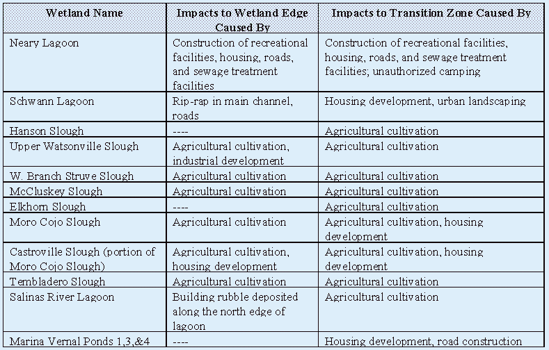
Figure 5-6: Time Series of Development Changes, Neary Lagoon, 1853-1994.
Click here to view Figure 5-6 Panels 1-4 of 8 OR Figure 5-6 Panels 5-8 of 8.
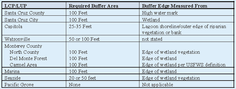
The requirement for buffer zones around wetlands is a contentious issue. The Coastal Act does not contain specific requirements for buffer zones, just general policy language for compatible, non-impacting adjacent development (Section 30240b), so landowners may consider all adjacent upland areas available for development. Although the Coastal Commission's Statewide Interpretive Guidelines (1981) suggest a minimum 100 foot buffer zone around wetlands, in practice wetland buffer widths are determined on a case-by-case basis with widely disparate results. [78] A review of the certified local coastal programs (LCPs) and land use plans (LUPs) covering areas with wetlands shows buffer area provisions vary among local jurisdictions (Table 5-3). The point from which the buffer is measured also varies.[79] These inconsistencies in LCP/LUP buffer area provisions no doubt compound the problem of inconsistent application. Furthermore, most LCPs allow exceptions to the stated criteria, if accompanied by some biological evaluation that a lesser buffer will suffice.
Table 5-3: LCP/LUP Provisions Relating to Wetland Buffer Areas
The scientific information necessary to determine the proper size of a buffer area in California is lacking, so it is not known if any of the LCP/LUP buffer provisions are truly adequate. This problem also carries over to questions regarding the structure a buffer area should provide. Leaving buffer areas in a natural state has obvious advantages, but may not provide proper protection to the wetland from adjacent development. For example, one common objective of buffer areas is to prevent domesticated animals from entering a wetland. Often the most straightforward solution is to erect a fence in the buffer area; however, this would restrict wildlife movement between the wetland and adjacent uplands. Clearly, our lack of information regarding the functions of buffers compounds the policy and procedural problems associated with securing buffer areas as a condition of development.
Regulated (e.g., urban) and unregulated (e.g., agricultural) development are both continuing sources of impacts to transitional zones and wetland edges. Although land use analyses suggest full buildout has nearly been reached in several portions of the project area, population levels are projected to increase. Thus, development pressure will continue. Likely areas for urban development include south Santa Cruz County and North Monterey County. Both areas contain substantial wetland resources including three large slough complexes: Watsonville Slough, Elkhorn Slough, and Moro Cojo Slough. Strong agricultural interests will remain in the project area well into the future. Cultivation practices may begin to change in the near term as a result of concerns over nonpoint source pollution; however, practices affecting buffer areas and wetland edges will probably not change substantially unless specific regulations are implemented.[80]
Based on these analyses, there is little doubt that transition zones and wetland edges will continue to be adversely affected in the future unless changes in management strategies are made. The chronic loss of these areas will adversely affect the quality of wetland habitat eventually leading to a loss in biodiversity and overall degradation of the resource. This is the situation in much of Southern California where the majority of wetlands exist in a degraded state and increasing wetland biodiversity is a primary objective of wetland conservation and restoration projects.
Continuing to follow and improve wetland setback regulations will help ensure that development near wetlands does not adversely impact the resource. Even greater assurance of protection is possible by undertaking a more specific planning process focusing on individual wetlands and their watersheds. A plan for an individual wetland can include an actual wetland delineation, allowing setback requirements relative to an accepted reference point. An inventory of, analysis of, and resultant plan for a wetland can result in a recommended buffer zone tailored to the attributes of that wetland (i.e., its species' needs and its habitat types). A plan can establish one or more optimal buffer zones along the wetland's entire perimeter depending on the type of adjacent development. It can include recommendations to manage the buffer zone and enhance it where degraded or where incompatible uses have encroached. The final problem section of this report details the status of and opportunities for this type of wetland planning.
The hydrology of most wetlands within the project area has been adversely affected by development.
The hydrology of coastal wetlands is made complex by their location at the interface between upland and aquatic environments.[81] Tides, waves, currents, freshwater discharge, and ground-water seepage are all important, but variable, elements of coastal wetland hydrology.[82] In California, wetland hydrology will also vary markedly with season, with many wetlands becoming dominated by freshwater during the winter/spring rainy period.[83],[84] In addition, the hydrology of wetlands in the project area is directly affected by the multi-year drought/flooding events that pervade California's climate.
A number of factors, both anthropogenic and natural, can affect the hydrology of wetlands. When human development alters a wetland's hydrology, the changes can adversely affect wetland size, water quality, and habitat quality. For example, past development in the coastal zone, particularly roads and railways, have muted (e.g., at Bennett Slough and Corcoran Lagoon) or in some cases completely severed (e.g., Upper Watsonville Slough and Schwann Lagoon) the connections these coastal wetlands had with the ocean. In most cases a road or other structure was built through the wetland reducing the size of one or more channels and resulting in the placement of culverts, weirs, or tide gates that restrict or exclude tidal flow. As a result, the amount of water that these wetlands receive and the movement of water through the wetland have been diminished. In addition, earthquakes have influenced the hydrology of some coastal wetlands in the project area. For example, the 1989 Loma Prieta earthquake increased the amount of saltwater reaching some wetlands (e.g., Struve and Bennett Sloughs) by rupturing the roads and culverts that restricted tidal flows,[85] and by lowering bottom elevations.
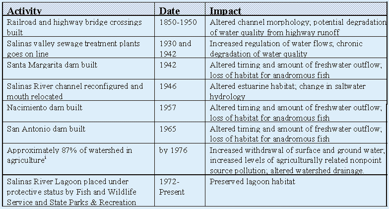
Information reviewed and compiled by ReCAP suggests the hydrology of virtually all wetlands within the project area has been altered to some degree by human activities, such as dam building, road construction, and urban and agricultural development in the surrounding watersheds.[86] A sequence of activities on the Salinas River illustrate the timing and type of activities which have adversely affected numerous wetlands within the region (Table 5-4). Cumulatively, these activities, which mainly occurred prior to the Coastal Act, have resulted in a reduction of the amount of salt- and/or freshwater reaching the wetlands, and changes in the timing and velocity of water flowing into the wetlands. However, natural events within the ReCAP project area have also affected hydrological processes. For example, the drought of 1987 to 1992 resulted in reductions in the amount of freshwater reaching all wetlands. In contrast, the Loma Prieta earthquake in 1989 increased the amount of saltwater reaching some wetlands. The anthropogenic alterations to wetland hydrology have tended to compound the effects of these natural processes leading to synergistic cumulative impacts, including reductions in water quality, changes in habitat composition, and reductions in habitat size and biodiversity.
Table 5-4: Sequence of Human Activities Affecting the Salinas River Watershed[87]
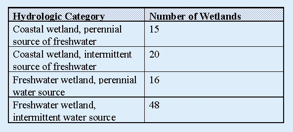
Thirty-five of the wetlands identified in the pilot area are true coastal wetlands, having one or more connections with the ocean (Table 5-5). Of these, 15 have a perennial source of freshwater. Thus, although marine processes dominate the hydrology of these wetlands, freshwater inputs are an important part of the overall hydrology. These coastal wetlands occur at the mouths of rivers as small estuaries or lagoons, or as large systems such as Waddell Creek Marsh and Elkhorn Slough. Sixteen wetlands have a perennial source of freshwater but no connection with the ocean. The hydrology of these wetlands is a function of the freshwater supply, which although always present, will vary with season and weather patterns (e.g., droughts and floods). Coastal and freshwater wetlands with an intermittent supply of freshwater account for 69% of the wetlands in the project area (Table 5-5). These include Arana Gulch, the Marina vernal ponds, and Spanish Bay wetland. The hydrology of coastal wetlands with intermittent freshwater inputs is dominated by marine processes. The freshwater supply to these wetlands will vary with surface runoff, which is highly seasonal.
Table 5-5: Gross hydrologic categories of wetlands in the ReCAP Pilot area
Natural hydrological changes in freshwater supply to a wetland can be inferred through an examination of river outflow data. For example, river outflow data for the Salinas River (Figure 5-7), show annual freshwater inputs between 1983 and 1993 were largely related to regional weather patterns. Freshwater flows were highest in 1983, an extremely wet year, and lowest during the drought years, 1987 through 1992. For those 15 coastal wetlands having a perennial freshwater source, these outflow data suggest hydrological conditions within the wetlands were dominated by marine processes over much of the last ten years. Typically, such a change in hydrology would result in increased salinity throughout the year, and could affect species' distribution and abundance. For example, several species of fish use coastal wetlands as nurseries in the spring when brackish (moderate salinity) waters prevail. During a drought there may not be enough freshwater to maintain brackish conditions throughout the wetland, forcing the fish to reproduce (often less successfully) further upstream or in a different wetland. In this way, substantial droughts, such as occurred between 1987 and 1992, could adversely affect reproductive output of some wetland dependent organisms. For those 64 wetlands relying solely on freshwater as a water source, the impacts could be more direct. The drought related loss of water to these wetlands would result in a reduction in the size of the wetland and loss of wetland habitat.
Figure 5-7: Salinas River Outflow at Sprekles, California
Hydrologic processes within some coastal lagoons occurring in the project area illustrate the interaction between natural and anthropogenic processes and the results that these interactions can have. Several of the major wetlands in the project area are coastal lagoons (e.g., Waddell Creek Marsh, Soquel Creek, Salinas River Lagoon, and Carmel River Lagoon), and thus subject to closure through the formation of berms at the mouth. The opening and closing of a lagoon mouth is fundamentally a natural process; however, anthropogenic alterations such as the upstream diversion of freshwater, excess siltation, or reconfiguration of the mouth have led to unnatural alteration of the timing and extent of this process.
Extended closure of a lagoon mouth can have numerous adverse affects including increasing the potential for flooding, causing extreme changes in water quality, and blocking fish migration. Three examples in the project area with coastal development permits illustrate some of the processes used to prevent the adverse impact of lagoon mouth closure:
(1) Santa Cruz harbor (Arana Gulch) was historically a coastal lagoon that was altered for use as a marina. Hydrologic conditions within the marina coupled with nearshore ocean currents require nearly constant dredging to maintain the harbor mouth. The harbor district has permits to operate a suction dredge at the mouth for much of the year at considerable cost. Even so, the mouth has closed several times over the last ten years inhibiting navigation in and out of the harbor, and resulting in the production of foul odors and fish kills.
(2) The lower San Lorenzo River is another coastal lagoon whose mouth has often closed during the summer, due to low flows and beach buildup. These closures have increased the potential for flooding and could adversely impact salmon and steelhead fish migration. A coastal development permit[89] was approved for placement of an outflow control device at the mouth, as an alternative to artificial breaching. However, the water elevation control device was never installed and the City later abandoned its permit due to liability concerns, so breaching is still proposed.[90] Currently, the Army Corps of Engineers has plans to dredge the lower river channel to improve flood storage capacity; this project would also increase the tidal prism and could reduce the incidence of mouth closures.
(3) Soquel Creek is in a situation similar to the San Lorenzo River. However, unlike the San Lorenzo River, a coastal development permit[91] was obtained to operate a water level control and fish bypass system and to allow breaching of the mouth as necessary. These examples, although of a common problem, illustrate three different approaches taken to achieve a remedy.[92] Overall, these three wetlands have been maintained as lagoon ecosystems, although at substantial costs to the public and natural resources.
Excess erosion or sedimentation is the most obvious result of changes to wetland hydrology. In terms of assessing the magnitude of this problem, Elkhorn Slough is the most well studied wetland within the ReCAP project area. A recent study[93] found that the construction of Moss Landing Harbor in 1946 dramatically altered the Slough's hydrology and initiated ongoing erosion. Between 1988 and 1993, approximately 420,000 cubic meters (approximately 70,000 cubic meters per year) of material was eroded from the subtidal portions of Elkhorn Slough. In addition, intertidal saltmarsh habitat has been retreating from the center of Elkhorn Slough at an average rate of 18 centimeters per year (cm/yr.) since 1946. Present day rates of saltmarsh edge retreat average 39 cm/yr. Thus, excessive development-induced erosion has been a chronic problem in Elkhorn Slough over the last 47 years, and the rate of erosion is increasing.
Meanwhile, excessive sedimentation is an ongoing problem in upper Elkhorn Slough. A recent report by Belden et. al.[94] found that two-thirds of the total sediment (approximately 178,070 tons/years) entering Elkhorn Slough is due to erosion from strawberry farms, although strawberry farms comprised only eight percent of the land use within the watershed. These unnaturally generated sources of excessive sediment will accelerate the conversion of wetland habitat to upland habitat. As wetland habitat is lost, fewer wetland dependent species can be supported. Existing policies governing land use in the coastal zone emphasize the protection of agricultural lands, limiting the regulatory alternatives for controlling agriculturally generated excessive sedimentation.[95]
Although human-induced acceleration of erosion and sedimentation are considered adverse impacts, these processes do occur naturally and play an important role in wetland ecology. A review of aerial photographs taken in 1977, 1986, and 1993 shows the location and size of some coastal wetland outlets have changed over time. For example, the outlet of Waddell Creek Estuary migrated north about 1000 feet between 1986 and 1993. At Scott Creek, the main channel was approximately 75 feet wide in 1986 (an extremely wet year), but only about 20 feet wide in 1993. The San Lorenzo River mouth was approximately 350 feet wide in 1986, but only about 50 feet wide in 1993, when substantially different shoaling and beach conditions existed. In 1986, the Salinas River flowed through the north lagoon before entering the ocean; however, in 1977 and 1993 the river entered the ocean well south of this lagoon. These examples illustrate how wetland hydrology contributes to the dynamic nature of wetlands, an aspect critical to the long-term maintenance and health of this resource.
Changes in wetland hydrology will also affect the plants and animals within a wetland. Reducing the amount of water available to the wetland will alter the types of organisms that occur in the wetland and the density of organisms the wetland can support. For example, Valencia Lagoon is a freshwater wetland that supports the Santa Cruz long-toed salamander, an endangered species. The hydrologic function of this lagoon is critical to the existence of this species. Reductions in salamander density have been linked to a loss of habitat due to adverse impacts to the wetland hydrology stemming from road construction.[96] Similarly, changes in wetland hydrology can result in water quality changes, which in turn can affect the resident biota. The discussion on the closure and maintenance of coastal lagoon openings above is a good example of the relationship among hydrology, water quality, and wetland biota.
Many of the factors affecting wetland hydrology do not occur directly in the wetland, but rather within the wetland's watershed. The project area includes portions of nine major watersheds (Figure 5-8). Much of the drainage area of these watersheds occurs outside the coastal zone; however, many of the wetlands within the pilot area occur at the ends of streams, rivers, and other drainage areas within the coastal zone, and are directly affected by activities occurring throughout the watershed. Urban development increases the amount of impervious surface within the watershed, leading to increased runoff rates and channelization. Timber harvesting and agriculture have resulted in increased rates of erosion and nonpoint source pollution.
Figure 5-8: Boundaries of Hydrologic units in the ReCAP area. Click here to view Figure 5-8.
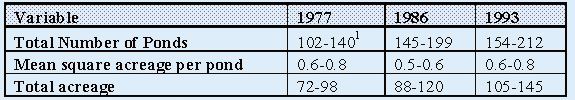
Urban and agricultural development also increase local needs for freshwater, reducing the amount of water flowing through the watershed and altering the timing of those flows. For example, aerial photograph analysis shows the existence of a substantial number of small detention ponds within the project area (Figure 5-9). These ponds are primarily used by agriculture and industry, but some may serve other functions as well. The ponds are generally small, but together cover a substantial area (Table 5-6). Some ponds are created through impoundment of small streams, but most are created in dry areas and filled with well water.[97] Between 1977 and 1993, the number of ponds increased by 51%. No doubt the presence of these detention ponds has affected the way water moves through the watershed. Although the ecological affects of these ponds are not well studied, it should be mentioned that these ponds are not without benefit. Perennial ponds can provide suitable habitat for freshwater marsh plants, and have increased the distribution of small freshwater wetlands over a broader area.[98] These ponds can provide resting and foraging habitat for migrating birds and wetland dependent animals. Yet it is unknown whether the benefits of these detention ponds outweigh the costs.
Figure 5-9: Relative location and number of detention ponds in the ReCAP area. Click here to view Figure 5-9.
Table 5-6: Summary Information for Detention Ponds
Overall, substantial portions of many watersheds associated with the project area have undergone significant development. Unfortunately, due to jurisdictional boundaries, regulations, for the most part, are not developed or enforced on a watershed basis. For example, between 1988 and 1992, the Department of Fish and Game processed 11 stream bed alteration agreements for projects located in Struve Slough. Although none of these projects occurred in the coastal zone, they all have affects on other locations in the watershed through alterations in the amount and timing of freshwater flows. This is a prime example of how adverse cumulative impacts could continue to occur within the ReCAP project area regardless of any procedural or policy changes made within the coastal zone, and why new watershed-based approaches for addressing these issues must be developed.
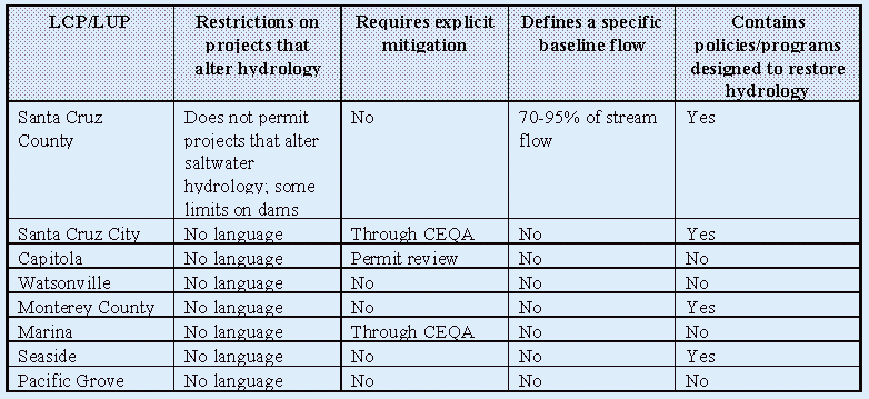
A review of the region's LCPs/LUPs shows that with the exception of Santa Cruz County, development projects affecting wetlands are not limited based on their potential to alter wetland hydrology (Table 5-7). Santa Cruz County's LCP contains policies prohibiting construction that alters saltwater inflows to coastal lagoons and limits some dam development based on instream flow requirements. In addition, none of the LCPs/LUPs contain explicit requirements for mitigating adverse impacts to wetland hydrology. Regulation of new development cannot solve hydrologic problems caused by on-going activities. Half of the LCPs/LUPs do suggest programs to restore hydrologic functions in wetlands, but funding and other program implementation is not specified.
Table 5-7: Results of LCP/LUP Review for provisions relating to Hydrologic Alternations
The process for regulating adverse impacts to wetland hydrology is complicated by the fact that wetlands comprise only a portion of larger watersheds that span multiple jurisdictions. Yet a wetland's hydrology is inextricably linked to hydrologic processes within the associated watershed. Hydrologic manipulations at wetland outlets would most likely remain in the Coastal Commission's original permit jurisdiction. However, alteration of freshwater flows could occur anywhere in a watershed. As mentioned previously, the coastal zone includes only a small portion of the watersheds in the Monterey Bay area, and other jurisdictional boundaries often bisect one or more watersheds. Activities permitted in one jurisdiction can have a direct affect on the hydrology of a wetland in another jurisdiction if these jurisdictions share the same watershed.
In terms of future trends, adverse impacts to wetland hydrology will continue unless changes are made to current regulatory and management practices. Although major development activities resulting in the largest changes to local hydrology have long since been completed, population projections suggest substantial increases in regional population over the next decade. Higher population levels would increase the demand for natural resources such as water and require additional development. Undoubtedly this would result in further degradation of wetland hydrology absent comprehensive mitigation measures. In addition, development in other parts of the coastal watersheds will continue. This development could also contribute to the cumulative degradation of coastal zone wetland hydrology. Meanwhile, numerous opportunities exist to restore and enhance the hydrologic functions of wetlands within the region. These projects could provide positive benefits both to the individual wetlands and in a cumulative sense to the natural resources within the region. Efforts to pursue all possible restoration opportunities must continue at all levels of government and within the community.[99] A new publication by the California State Coastal Conservancy entitled Options for Wetland Conservation, A Guide For California Landowners (1994) provides valuable information relevant to this issue.
Continuing to follow and improve existing regulations will help ensure that hydrologic impacts from new development do not occur or are adequately mitigated. Even more assurance can be gained by undertaking a more specific planning process focusing on individual wetlands and their watersheds. Such a plan can describe current and optimal hydrologic conditions to serve as a basis for analyzing new projects.[100] Such a plan can also anticipate likely hydrologic manipulations (e.g., river lagoon breaches) and provide criteria for (or recommend alternatives to) them. Finally, a wetland management plan can also review existing hydrologically-impacting structures (e.g., a broken tide gate) or activities (e.g., pumping) and recommend remedial actions.
There is a definite trend by many government agencies to use a
watershed approach as the basis for comprehensive natural resource
planning. This approach offers additional opportunities for the
management and conservation of wetland hydrology based on processes
and activities occurring throughout the watershed. In addition,
this approach could help to reduce duplication, foster cooperation
and consistency, and result in more efficient use of limited government
funds. Such a plan can recommend regulatory improvements to uniformly
apply to new development in the watershed as well as necessary
programs to address existing contributory activities and uses.
The final problem section of this chapter outlines the status
of and opportunities for such planning initiatives.
The water quality status of most wetlands within the project area is unknown, although some wetlands are known to have suffered adverse impacts due to human development.
Water quality is defined here as the physical, chemical, and biological
integrity of a water body. Proper wetland water quality is necessary
to provide an environment that not only supports the existence
of wetland plants and animals but allows for their reproduction
and growth. Thus, water quality is a direct measure of the health
of a wetland. However, interest in wetlands has intensified recently,
because of the ability of wetlands to enhance water quality. Through
a variety of processes, wetlands are able to remove sediments
and both organic and inorganic pollutants from the overlying water.[101],[102]
Unfortunately, much of the water quality information available in the project area is inappropriate or unsuitable for determining the long-term cumulative impacts to wetland water quality. Although a large amount of water quality data has been collected from wetlands within the pilot area, most of the information was collected to answer project specific questions. In addition, sampling methods and testing criteria vary considerably. Thus, much of the available data cannot be readily used to establish general water quality conditions or long-term trends for specific constituents. A 1976 assessment of water quality conditions in Santa Cruz County found that "in-depth examination of the surface and ground water historical water quality records indicates that there is insufficient information to adequately define the long-term, short-term, and areal variations for most of the County".[103] A recent assessment of water quality information by the Monterey Bay National Marine Sanctuary shows relatively little is still known about the quality of water in the project area
There is information that shows nonpoint source pollution is adversely
affecting some wetlands in the project area at various times.
For example, there are numerous reports of elevated coliform bacteria
counts.[104],[105],[106] Elevated bacterial concentrations typically
occur after winter storms, suggesting nonpoint source runoff is
responsible. Although coliform bacteria problems mainly occur
in wetlands surrounded by pasture lands and agriculture, there
have been reports of problems in urban areas. Neary Lagoon provides
a recent example. It is estimated that Neary Lagoon receives nearly
two-thirds of Santa Cruz city's urban storm water runoff.[107]
Fecal coliform levels in excess of 500 percent of the State and
Federal water quality standards have been documented in the lagoon.[108]
This situation has persisted for a number of years, and only recently
has the Regional Water Quality Control Board required Santa Cruz
City to apply for a federal discharge permit in an attempt to
regulate this problem.
The introduction of pesticides, heavy metals, and other pollutants
into wetlands in the project area is of ongoing concern. Unfortunately,
long term monitoring data are generally not available. Additionally,
the in-depth studies necessary to identify, track, and quantify
these pollutants are generally cost prohibitive. The few studies
completed show pesticides do exist in some wetlands within the
project area. Specifically, studies of Moro Cojo Slough, Elkhorn
Slough, Moss Landing Harbor, and the Salinas River Lagoon all
concluded that pesticides do occur in these wetlands.[109],[110]
Pesticides are thought to enter these wetlands with nonpoint source
runoff from surrounding agricultural areas. In contrast, heavy
metals and other pollutants such as domestic sewage are thought
to enter wetlands with urban runoff. Thus, these pollutants are
most prevalent in wetlands surrounded by urban areas and large
developments such as central Santa Cruz County, the city of Marina,
and Spanish Bay. Urban runoff into some of these wetlands can
be substantial given their size. For example, 28% of the watershed
draining into Majella Slough (approximately 25 acres) is now part
of the Spanish Bay development.[111] Also, Marina Vernal Pond
# 1 (approximately 10 acres) receives runoff from approximately
13 acres of an adjacent stretch of Highway One.[112] Thus, while
it cannot be determined if water pollution in the project area
is widespread, there clearly are areas of concern.
As with hydrology and morphology, many of the factors affecting
wetland water quality do not occur directly in the wetland, but
rather occur within the wetland's watershed. Along with urbanization
come new sources of pollution (e.g., household pesticides, fertilizers,
motor oil, and cleansers) that can enter the watershed with stormwater
runoff. Timber harvesting and agriculture can result in increased
rates of erosion and nonpoint source pollution. These sources
of pollution have had adverse impacts on wetlands located in both
urban (e.g., Neary Lagoon and Schwann Lagoon) and agricultural
(e.g., Elkhorn Slough, Upper Watsonville Slough, and Tembladero
Slough) areas.
Point source discharges also exist within the project area. A
review of current waste discharge permits shows there are 13 active
discharges into local streams and 5 active discharges into local
wetlands.[113] These discharges include treated sewage, overflow
from settling ponds, cooling water, and effluent from vegetable
and meat processing plants. The exact effects of these discharges
are not fully known.
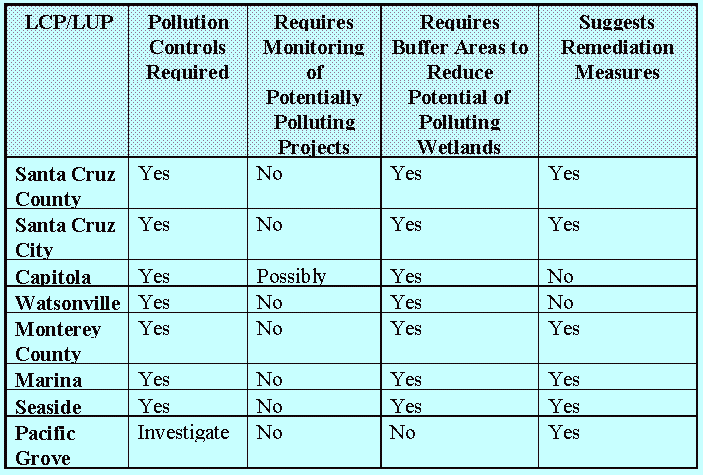
A review of the LCPs/LUPs covering areas with wetlands, revealed
all but one included some pollution control requirements (Table
5-9). (The City of Pacific Grove's policy is simply to investigate
potential pollution problems.)[114] Requirements include provision
of erosion controls, as well as sediment and grease traps, which
are implemented on a case-by-case basis. Maintenance of such devices
is generally stipulated, but there are no requirements to monitor
specific pollutants or potential project related sources. With
the exception of Pacific Grove, all LCPs/LUPs require wetlands
to have buffers (which can help protect wetland water quality).
In no case has an analysis been performed leading to information
on maximum acceptable pollutant loading into a wetland. All but
two LCPs (Capitola's and Watsonville's) suggest programs aimed
at reducing existing pollution problems; however, Capitola has
recently adopted a management plan to do so for Soquel Creek,
its only wetland.
Table 5-9: Results of LCP/LUP Review for Provisions Relating to Water Pollution
It is hard to predict future trends for water quality in the absence
of appropriate information. Land use analyses suggest full buildout
has nearly been reached in several portions of the pilot area.
If more recent activities such as infill development and changes
in zoning decline as full buildout is reached, then the adverse
impacts to water quality from development activities should stabilize.
In contrast, population projections suggest substantial increases
in regional population over the next decade. Higher population
levels would increase the potential for pollution, particularly
nonpoint sources. However, government agencies, such as the Coastal
Commission, Monterey Bay National Marine Sanctuary, and Regional
Water Quality Control Board, continue to refine and enhance education
programs and regulatory measures aimed at reducing and/or preventing
impacts to water quality. One such effort is the Coastal Commission's
project of special merit to address polluted runoff.[115] These
agencies must remain proactive in their work to safeguard water
quality. Although the constraints and costs to the individual
may at times seem excessive, the cost of remedying chronic and
cumulative adverse impacts to water quality is many times greater.
Left uncorrected, the cumulative degradation of water quality
will ultimately have adverse affects on many other economic resources
(e.g., tourism, agriculture, and fishing) within the region.
Continuing to follow and to improve existing regulations will help ensure that adverse water quality impacts from new development do not occur or are adequately mitigated. However, as discussed in the preceding Hydrology section, real progress in addressing water quality is best achieved through watershed planning and management. Such a planning process can comprehensively address all sources polluting a wetland and coordinate responsibilities for controls and remediations. The final problem section of this chapter outlines the status of and opportunities for such planning initiatives.
An understanding of wetland biodiversity in the project area is necessary to fully protect and manage wetland resources. However, such an understanding cannot be determined at this time due to a lack of appropriate information. Nonetheless, there are indications that wetland biodiversity has declined due to human impacts.
The plants and animals that exist in or rely on wetlands comprise
the biological component of the wetland ecosystem. Providing the
function of wetland biodiversity, that is, providing the resources
that result in the existence and reproduction of a diverse array
of species, is considered one of the most important functions
of wetlands today. Measurements of species' number and their abundance
is one way to quantify the value of this function. The establishment
of exotic species, the number of special status species, and changes
in the number and abundance of native species are indicators of
changes in biodiversity. A reduction in biodiversity is indicative
of a wetland that has suffered adverse impacts.
There are several cases where actual changes in biodiversity have
been noted; the majority of cases conclude that a reduction in
native species has occurred.[117] In terms of animals, fewer steelhead
have been found in Carmel River Lagoon, clams have virtually disappeared
from Moss Landing North Harbor (once part of the Old Salinas River
Channel), fewer fish occur in the Pajaro River Marsh, and fewer
invertebrates populate the Salinas River Lagoon. In terms of plants,
non-native species have supplanted cattails in Gallighan Slough
after it was deepened by peat harvesting, lupines in the UC Santa
Cruz Inclusion Area A Seasonal Wetlands disappeared after heavy
grazing, vegetation changed at Majella Slough as a result of mining
activities, and willows died in the Blohm-Porter Marsh (a portion
of Elkhorn Slough) after harbor construction opened it to tidal
influence. Grazing and agriculture in McCluskey Slough are thought
to have resulted in a loss of native species and a concurrent
increase in introduced species. These changes may be responsible
for a decline in the abundance of Santa Cruz long-toed Salamanders,
which inhabited McCluskey Slough.
Although a large amount of biodiversity data has been collected for wetlands within the project area, much of this information is inappropriate or unsuitable for determining the long-term cumulative impacts to wetland biodiversity. For example, numerous studies contain information related to plant biodiversity. However, a review of several reports shows the study results are highly dependent on the amount of time spent completing the survey and the area covered. Various biological surveys of wetlands in the pilot area found between 2 species of plants in Moro Cojo Slough and 249 species of plants in Elkhorn Slough (Table 5-10). On average, 36 species of plants were found.[118] Surprisingly, few surveys identified the number of special status (rare, threatened, or endangered) species. Slightly more information was available for exotic species.
Table 5-10: Examples of Plant Species Biodiversity Survey Results[119]
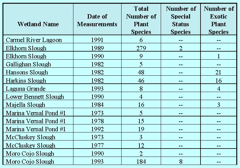
Fewer studies included information relating to animal biodiversity
(Table 5-11). Much of the data was categorized among animal groups
such as mammals, birds, amphibians, and fish (Table 5-12). However,
making comparisons among wetlands using these data would be erroneous
without first standardizing the data based on a common level of
survey effort. As with plants, the data was quite variable. For
example, two different surveys of Elkhorn Slough identified 7
and 404 animal species respectively (Table 5-11). Few surveys
identified special
status species or non-native species. All of the survey reports
containing animal species abundance or distribution data reported
data for various groups of animals (e.g., birds, mammals, reptiles,
etc.). Birds were most commonly identified, followed by mammals.
Methods for completing such surveys were rarely stated, although
the results suggest a high degree of variability. In particular,
many reports included listings of "species that may potentially
occur in the wetland based on the presence of appropriate habitat".
Identification of appropriate habitat was based on gross observations.
Table 5-11: Examples of Animal Species Biodiversity Survey Results[120]
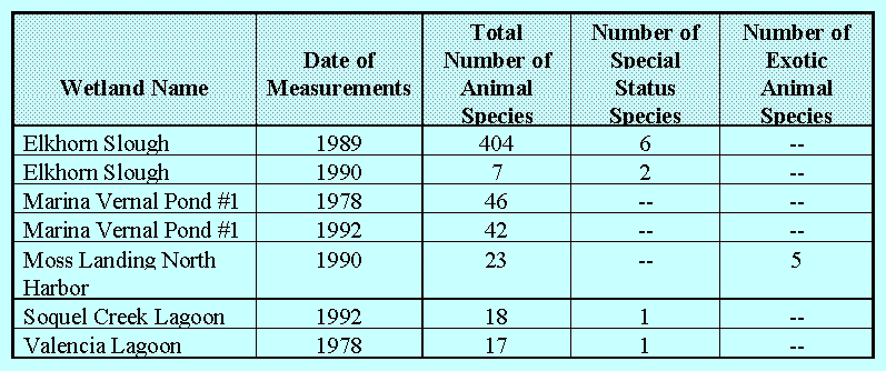
Table 5-12: Animal Species (By Group) Biodiversity Survey Results[121]
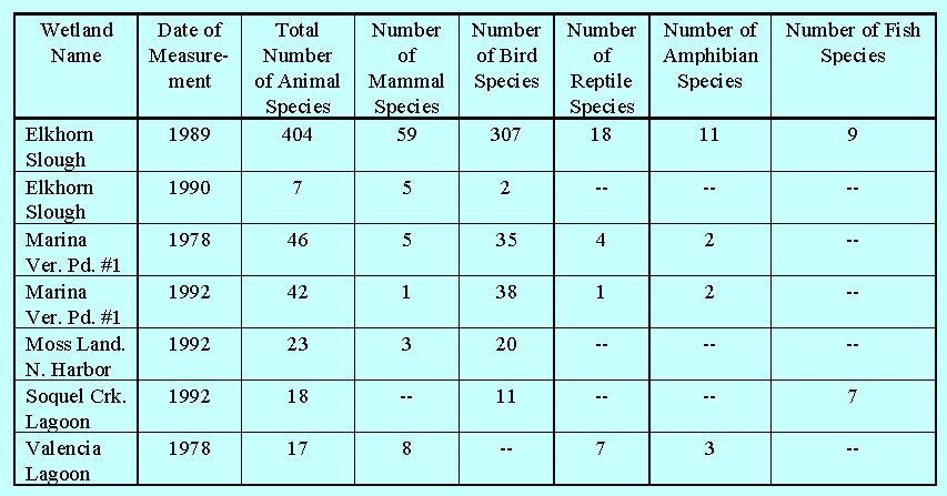
In general, little can be concluded from the review of this data.
Much of the variability among surveys is attributed to methodological
differences, rather than actual differences in biodiversity. Although
repeat surveys were completed in several wetlands, generally the
time span between surveys was relatively short. One exception
was two surveys completed for Marina Vernal Pond #1. These surveys
conducted in 1978 and 1992 found similar numbers of plants and
animals in the wetland (Table 5-10 and Table 5-11), although species
numbers among animal categories varied somewhat (Table 5-12).
Given the available data, however, it is not possible to directly
determine the cumulative impacts to wetland biodiversity. These
findings point to the critical need for standardized methodologies
in assessing wetland biodiversity. The methods used should yield
the information necessary to answer project specific questions,
as well as the appropriate information for assessing the cumulative
impacts to biodiversity over time and space.
Other types of data were also examined in an attempt to characterize
regional changes in biodiversity. The presence of special status
species or their habitat may provide an indication of a change
biodiversity. An inverse relationship presumably exists between
biodiversity and the number of special status species. That is,
as overall biodiversity is negatively impacted, more species are
placed in jeopardy of extinction, some of which receive special
status listing (34%). As the number of special status species
increases so does the number of habitat types critical to their
existence. So the presence of special status species or their
habitat may be indicative of a decline in a wetlands' ability
to maintain biodiversity. A review of the ReCAP database shows
34 wetlands within the pilot area either contain special status
species or appropriate habitat. This suggests that species biodiversity
in the project area has been adversely impacted.
A review of the LCPs/LUPs within the region showed they all provide
indirect protection for biodiversity through the recognition and
enhanced protection of select habitats. Typically, the LCPs/LUPs
specifically identify select habitats (e.g., habitat for the Santa
Cruz long-toed salamander) or specific areas (e.g., Laguna Grande)
that are rare or have received recognition because of their uniqueness
in the local area. These habitats are identified as environmentally
sensitive habitat areas, which severely limits development under
the provisions of Coastal Act Section 30240. However, is it not
known if the indirect approach incorporated into LCPs/LUPs to
protect biodiversity is preventing the loss of wetland species
or appropriate habitat.[122] This suggests a more consistent,
direct, and proactive approach is needed to ensure the preservation
of wetland biodiversity.
Although there are indications that wetland biodiversity is decreasing
in the project area, the lack of consistent long-term biological
(e.g., species abundance and distribution) and ecological (e.g.,
habitat type and condition) information prevents predictions of
future trends. In addition, changes in the regional biodiversity
of wide ranging species such as birds are affected by processes
occurring outside the project area and outside the region, further
confounding predictions of future trends. The analyses above suggest
that the future condition of wetland biodiversity is to some extent
related to land use changes within the region. On a basic level,
additional development that directly or indirectly affects wetlands
will affect biodiversity.
Continuing to follow and improve the regulatory process can help
ensure that new development does not further affect biodiversity.
Even greater assurance can be gained by undertaking a more specific
planning process focusing on individual wetlands and their watersheds.
A plan for an individual wetland can more specifically identify
permitted uses, mitigation measures, and buffers to protect its
specific plants and animals. Furthermore, in identifying existing
habitat types, hydrologic systems, and water quality, such a plan
can recommend improvements that would conserve or enhance biodiversity
as well. Complementary broader-based natural community, watershed,
and regional planning can further advance biodiversity protection
and restoration at the level necessary to address entire habitats
of species that frequent wetlands and the activities and land
uses that affect them. The final problem section of this chapter
outlines the status of and opportunities for such planning initiatives.
Each stage of the decision-making process regarding wetland projects -- from project conception and wetland identification to follow-up monitoring and management -- could be improved with the generation of better information and by improving access to that information.
ReCAP has found that analysis of cumulative impacts to the project
area's wetlands is hampered by the lack of readily available and
useable data. Direct access to reliable and accurate data is important
in all stages of the CCMP in order to improve identification of
wetlands, to assess impacts, to develop appropriate alternatives
and mitigation measures, and to evaluate condition compliance
and restoration success.
In reviewing Commission and local government permit files, ReCAP found the problem of information gaps evident in several aspects of the CCMP:
Wetland Identification
Knowledge of a wetland's existence and boundaries is crucial to managing the resource. Coastal managers need direct access to an inventory of wetlands to guide wetland site identification and delineation. Without such information, a site visit may not be performed or a wetland may be missed. Access to reliable, updated site delineations would further increase assurance of wetland identification and appropriate regulatory action. Access to maps and descriptions of individual habitat types would also assist coastal managers in identifying adverse impacts and in devising appropriate mitigation requirements.
ReCAP discovered cases where identified wetlands were not acknowledged in previous regulatory actions. These cases arose where previously approved projects were never built and new site information become available upon project resurrection. For example, at Terrace Point, environmental studies in 1981 and 1987 failed to note any wetlands (the area was under cultivation), whereas a 1994 field investigation revealed four wetland areas totaling 12 acres.[123] At a site formerly called Villa Nueva or Rolling Hills I, a small ponded area and a swale not identified in 1982 and 1986 are now delineated as "wetlands" under standard criteria applied by the U.S. Army Corps of Engineers. [124]
Previous efforts to inventory, locate, and delineate all of the area's wetlands have been incomplete. To date, the wetland location map provided in this report is the most comprehensive listing of all of the area's wetlands (see Figure 5-2). Yet, there is no single repository for wetland delineation maps. The U.S. Fish and Wildlife Service began a national wetland inventory program, the National Wetland Inventory, in the 1970's. Although all of the ReCAP area in Monterey County was inventoried, only about 50% of Santa Cruz County has been inventoried.[125] ReCAP identified 99 wetlands totaling about 6200 acres based only on staff review of the literature and aerial photography interpretation. However, some of the wetlands identified by ReCAP staff are not shown on the National Inventory maps. Further, only 59 wetlands (61%) were identified in the aggregate by background work done in the late 1970's to the early 1980's for the Local Coastal Programs (Table 5-13).
Table 5-13: LCP Wetland Identification
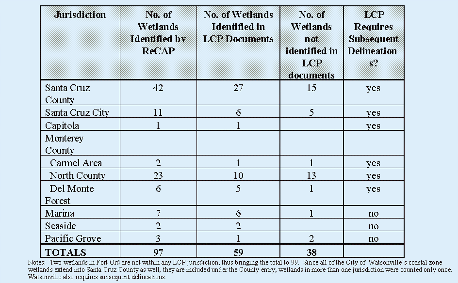
It should be noted, however, that the wetlands not identified in the LCP documents are comparatively small, representing only about 3% of the total wetland acreage. The categories of wetlands identified by ReCAP, but not in the LCPs, include:
The existence of some of these wetlands became evident through the regulatory process. Generally, they were noted in environmental impact reports or in biological investigations that were based on actual field work.
The wetland regulatory process would be improved if coastal managers had direct access to a complete inventory of wetland resources. Development of such an inventory will necessitate detailed field work. In turn, successful field work would require manuals and training to identify appropriate indicators, as well as the necessary time, maps, and other tools to perform a complete delineation. Ultimately, wetland management would benefit if all the region's wetlands and their component habitats were named and accurately mapped on a computerized Geographic Information System (GIS) directly accessible to all.
In order to increase ease of access to available information, improvements could be made in how information is collected in the regulatory process. Also, ensuring timely and complete information from all permit applicants will assist coastal decision makers in providing a prompt, fair and thorough review. To foster a scientific basis to regulatory actions, it is also important that the information is prepared by qualified persons.
ReCAP encountered a range of informational requirements for projects involving wetlands and varying responses. For example, the California Environmental Quality Act (CEQA) requires biological analysis, but its guidelines do not address specific wetland parameters. Furthermore, approximately one-third of coastal permit applications from 1983-1993 involving the region's wetlands have been found exempt from CEQA provisions. The Coastal Commission staff recently completed a Wetlands Procedural Guidance Document for the Review of Wetland Projects, which lists items that should be included in permit applications.[126] Santa Cruz County has a tiered system. Initially staff performs a biotic evaluation, and based on the results, may then require a more thorough biotic report prepared by a technical specialist.[127] Monterey County's Local Coastal Program appendices spell out required contents of biotic reports. Such reports are required for sites containing or adjacent to a wetland. A cursory review of biological reports submitted with local and Coastal Commission permit applications showed a wide range in content.
In reviewing authorized developments, ReCAP found that monitoring requirements for restoration and mitigation projects varied greatly. Out of 39 projects, 20 required monitoring and 6 apparently did not (the record was unclear for the remaining 13 projects). The most common monitoring period was 5 years. Although thorough evaluation of the scope and effectiveness of local monitoring programs was not attempted, a common finding of a preliminary review was the lack of appropriate information including goal statements, baseline condition presentations, and as-built descriptions and assessments.[128] Currently, the U.S. Army Corps of Engineers has thorough monitoring report guidelines.[129] These guidelines could be used by other agencies who currently lack them. The Coastal Commission is currently developing a procedural guidance document that provides information useful to developing wetland monitoring plans.
Reports submitted with permit applications and monitoring reports typically present only project-specific information (see Water Quality and Biodiversity sections of this chapter and the Coastal Commission's Elkhorn Slough Watershed monitoring report[130]). As a result, cumulative impacts on wetland systems are difficult to quantify. Overall biodiversity or water quality may be declining in a wetland system, while the specific plant species that a project was required to protect or enhance may be flourishing, or the specific discharge that a project was required to control may be lower in concentration than the ambient condition. Ultimately, agreement should be reached on specific standardized indicators and protocols for all required project and monitoring reports.
Systematic Presentation Allowing Cumulative Impact Finding
The background section to this chapter illustrates a systems diagram for wetlands (see Figure 5-4). Depending on the complexity of a project, analysis should assess how the project impacts each component of the system. A systematic understanding is also necessary to recommend and to evaluate appropriate alternatives or mitigation measures. Watersheds would typically define the outer system boundaries. As is the case for wetlands, common identification and descriptions of watersheds is lacking in the region.[131]
A review of 20 coastal permits involving development in and adjacent to wetlands in the Live Oak area of Santa Cruz County revealed that analysis focused almost exclusively on the subject project and site. As illustrated in Table 5-14, there was little discussion of the project areas in the context of the wetland system and hence potential cumulative impacts to wetlands were rarely addressed.
Table 5-14: Cumulative Impacts Analysis Characterization in the Regulatory Process(Live Oak Area)

In other cases, more extensive analyses of cumulative impacts
have been attempted.[132] One notable example is at Neary Lagoon
where a massive wastewater treatment plant was proposed adjacent
to the wetland. As indicated in Figure 5-6, this proposal followed
a series of other adjacent developments. The project's EIR qualitatively
attempted to discuss the cumulative effect of these structures
which "walled" in the lagoon bird habitat.[133] In other
cases, cumulative impacts have been addressed (in a limited sense)
but the mitigation deferred. For example, permits allowed immediate
culvert repairs coupled with the longer-term development of monitoring
and/or management plans.
Cumulative impact analysis has also been employed in the regulatory
process for two wetland watersheds. At Valencia Lagoon, a breeding
pond for the endangered Santa Cruz long-toed salamander, the total
amount of potential development was analyzed. As a result, each
individual project had to conform to measures intended to mitigate
cumulative effects. At Elkhorn Slough, development was supposed
to stay within targets designed to prevent
cumulative erosion problems. Until these targets were developed
(as part of the local coastal program process), new subdivisions
were denied, pursuant to the cumulative impact provision in Coastal
Act Section 30250(a).
While comprehensive wetland and watershed planning can best address
cumulative impacts (see last section of this chapter), regulators
meanwhile develop and use limited cumulative impact information
in reviewing individual projects, as these examples illustrate.
Agency Information Sharing and Coordination
Coastal managers can use existing resources more efficiently by
sharing information and expertise. Efforts have begun in the pilot
region to do this, through ReCAP, the Monterey Bay Initiative
and the Coastal Aquatic and Marine Projects Information Transfer
System (CAMPITS) program. Development of further mechanisms to
share information about other agencies' actions and to increase
coordination prior to decisions can improve wetland management.
There are some examples of intergovernmental coordination mechanisms
that are useful in resolving potential wetland management problems
before much project design and investment has occurred. For example,
the U.S. Army Corps of Engineers holds voluntary, monthly interagency
meetings (before applications are filed) for projects requiring
Corps' Section 404 permits. The Department of Fish and Game, Environmental
Protection Agency and other appropriate agencies are invited and
usually attend; the Coastal Commission is invited for projects
in the coastal zone. Roughly 25% of the applicants to the Corps
take advantage of these pre-filing meetings, with a higher attendance
rate for larger projects.[134] Although exact figures were not
gathered, a number of coastal permits involving wetlands have
been the subject of these interagency meetings. In other cases,
coastal planners often make informal contact with other agency
personnel, but no tabulated accounting of such contacts is available.
After the Coastal Commission approves a permit involving a wetland,
it typically conditions permit issuance to receipt of other agency
permits, such as those of the Department of Fish and Game and
the U.S. Army Corps of Engineers. In contrast, very few locally-issued
coastal permits are conditioned for receiving other agency approvals.
In the absence of consolidated wetland project review, coastal managers can continue to improve their information base by increasing and formalizing interagency contacts.[135]
Access to Hydrological and Biological Expertise and Training
Some level of scientific training is desirable for staff involved
with the planning, regulating, or managing of wetlands. For example,
in order to identify wetlands, a certain level of biological expertise
is necessary. In order to understand the wetland system components
discussed in this report, knowledge of hydrology and biology is
helpful.[136] A basic knowledge of these factors and relationships
is helpful in suggesting the contents of environmental reports,
in developing alternatives and in making informed decisions. A
review of coastal permit applications involving wetlands shows
that many technical issues are posed. Out of 64 projects in wetlands,
26 posed hydrologic issues. The majority of these involved culverts
and/or associated water control devices or sand bar breaching.
A review of restoration projects, discussed above, also showed
technical issues present in determining success and suggesting
corrective measures.
Coastal managers could improve the ability to evaluate these technical
issues by increasing access to, and sharing, available scientific
expertise and training. Currently, state and local coastal managers
seem to gain information and assistance in wetland science through
information in EIRs and the consultants preparing these documents,
from the staff of state and federal resource agencies and, in
some cases, from Commission technical staff. In cases where biologic
information is required, the providers have usually had biological
training. A small number of consulting firms with specific wetland
expertise and experience now provide the bulk of the technical
information required by permitting agencies in the project area.
For example, a review of five projects with EIR's in the Live
Oak area showed that the preparers of at least the three most
recent ones included biologists.[137] LCP requirements for wetland
reports typically specify preparation by a "qualified"
biologist. Technical consultation and information is sometimes
provided to coastal managers by staff of the Department of Fish
and Game and the federal resource agencies. Although the Department
of Fish and Game (DFG) is a central source of expertise for the
Coastal Commission, DFG personnel availability has limited the
number of consultations in the region.
Given limited staff and resources, mechanisms need to be developed to make more efficient use of existing expertise in wetland systems. Mechanisms to share staff and to develop staff training programs and technical assistance programs can help increase access to, and knowledge of, wetland management.[138]
Information Storage and Retrieval
The greater the availability of useful information, the more informed staff and decision-makers can become. Varied accessibility has resulted in an uneven approach to using relevant information. Initial steps to improve access to available records were taken in the establishment of the Coastal Resource Information Center in the Commission. Cataloguing and access to available documents is ongoing, albeit slowly. Efforts are underway to make access to library catalogues available from Commission computers. ReCAP examined over 350 documents from Commission records concerning the area's wetlands, but less than 10% are catalogued in the Coastal Commission's library to date. Setting priorities for cataloguing the reminder of these documents would help accelerate access to this information. In the process of ReCAP, many wetland-related reports prepared by other agencies or academicians were discovered that were not known to or available to staff or decision-makers. The same wetlands may be identified by different names and in different ways, thus making comparison among reports difficult. Maps of individual wetland are scattered among these different sources and are of varying scale and quality. It is apparent that there is a fair amount of technical information existing which would help coastal managers and decision makers if it were more directly available.
The above analysis suggests several areas where information or
its use can be improved. Fortunately, some improvements are emerging
as discussed in the following examples.
One agency, the Department of Fish and Game, is comprehensively
reevaluating its programs. The Coastal Commission has recommended
increasing information exchange and increasing input on coastal
permit decisions from that Department as a way to improve implementation
of the CCMP.[139] The Clean Water Act allows for state assumption
of some Corps permitting functions in wetlands. While this program
has generated controversy and is not necessarily recommended for
California, pursuit of the concept may lead to protocols for better
utilization of expertise and information among state and federal
agencies.[140]
With regard to mapping wetlands and watersheds, the Coastal Commission
has available computer hardware and software that should eventually
enable the storage and retrieval of such information. Some local
governments have such capability, but none has a complete file
of computerized wetland identification maps. The State Department
of Forestry and Fire Protection is digitizing watershed boundaries
for the whole state. Santa Cruz County plans to name its delineated
watersheds and perform further, more individualized watershed
mapping. The Commission could play an important role in coordinating
these efforts.
ReCAP developed a computerized wetland database to summarize information on permits, morphological, physical, chemical, biological, bibliographical, and basic attribute information that it has reviewed. After the database modules are completed and an operational guide written, the database will offer an opportunity fo r agencies and the public to use and exchange the available information.
Not only will improvements in the flow of information directly
assist wetland management and regulatory decision-making, its
use in the planning process may lead to improved decision-making.
The wetland and watershed management planning processes described
in the following section of this cha pter can base recommendations
on compiled and analyzed information. The resultant plans thus
provide the context on which to base future decisions. For example,
a plan may describe an optimal wetland system, including restoration
areas and standards. A subsequent applicant could then incorporate
such provisions as project mitigation.[141] Planning also offers
an avenue through which to address cumulative impacts. Plans can
set maximum densities or coverages or requirements that assure
cumulative impact thresholds are not exceeded. Individually permitted
projects then have to simply comply with these requirements without
the need to generate extensive original cumulative impact information.
In the above-mentioned cases for Valencia Lagoon and Elkhorn Slough,
such provisions were incorporated into the local coastal programs.
While regulatory evaluation may still be necessary after planning
is complete, it could be performed within a pre-defined context
relying on directly available information. Acceptance of such
plans by all agencies with regulatory authorities might lead to
future efficiencies in the decision-making process itself.
On a regional level, improvements in the flow of information can
lead to its use in setting priorities for wetland and watershed
improvement initiatives as well as to identify gaps to be addressed
by future research. A logical next step would be to identify an
appropriate regional framework for wetland information compilation
and dissemination.
With regard to wetland and watershed identification:
With regard to information requirements:
With regard to cumulative impact information:
With regard to interagency information sharing:
With regard to training
With regard to information storage and retrieval:
See also, the Information Management section of this report.
The lack of a comprehensive wetland and watershed management framework has led to piecemeal decisions that do not fully protect the region's wetlands. In particular, individual decisions made on projects in wetlands without comprehensive management plans cannot readily account for cumulative impacts.
The California Coastal Management Program's primary implementation
mechanism -- regulation under local coastal programs -- does not
fully address the cumulative impacts to wetlands identified earlier
in this chapter. LCPs primarily address new development, whereas
ReCAP found that in the pilot area, existing uses and activities
are the more significant contributors to cumulative effects. LCPs
cover only the coastal zone, but activities throughout a wetland's
watershed may have substantial cumulative effects on wetlands
in the coastal zone. Many watersheds are bisected by the coastal
zone; for some watersheds, only a small portion resides within
the coastal zone. LCPs are divided by political jurisdiction,
whereas some cumulative effects on wetlands are regional. LCPs
primarily regulate the jurisdiction's land use actions, and not
typically the regulatory or management actions of other agencies
with authority over wetlands (e.g., a Department of Fish and Games
decision to allow hunting in a wetland). On the other hand, LCPs
can set fairly specific land use standards, but are often not
of the detail needed to address many wetland cumulative impact
concerns. Initiation of proposed LCP amendments are at the discretion
of the local governments, so new or more detailed wetland initiatives
are not automatically incorporated into an LCP.
Another complicating factor is that some wetlands or parts of wetlands remain under Coastal Commission permit jurisdiction, even after local coastal program certification.[142] The same regulatory limitations noted here that local governments operate under also apply to the Commission's permitting authority and to some extent, its federal review authority.[143] In some cases, a project in or affecting a wetland may require two separate coastal permits -- one from the Commission and one from the local government -- further fragmenting the decision-making process. The preceding sections of this chapter conclude that new planning and management initiatives at various geographic and jurisdictional levels are necessary to more completely address the identified problems.
Within the complex regulatory, ownership, and management milieu that affects wetlands, a strategy to address both the broad and specific aspects of cumulative impact concerns is already emerging in the pilot area. Four levels of planning and resultant management are operating: by region, watershed, jurisdiction, and wetland. Another level, encompassing natural communities, may become a factor. Building on this framework in the short-term and possibly refining it in the longer-term offers a means to further protect wetland resources.
Region
The Monterey Bay National Marine Sanctuary's Integrated Coastal
Management (ICM) process is a particularly promising prospect
for coordinating regional wetland planning and management in the
project area. Through the ICM process, the various agencies with
wetland management responsibilities could gather and disseminate
information on all the area's wetlands and respective watersheds;
continue to analyze the identified problems, especially their
interrelationships in a regional context; prioritize problem areas
needing attention; and guide and coordinate solutions. Several
states and regions are undertaking such an approach, including
the San Francisco Bay area, which may serve as useful models.[144]
To date, efforts to plan for wetlands on a regional basis in the
Monterey Bay area have been limited: U.S. Fish and Wildlife Service's
National Wetland Inventory simply mapped wetlands by habitat type
for part of the area in the mid 1970's; Santa Cruz County's Parks,
Recreation, and Open Space Plan of 1972 identified many of the
County's wetlands and recommended that they be the subject of
specific plans; the Coastal Conservancy reviewed the status of
wetlands in the area and listed 21 potential enhancement projects
in 1979; the California Assembly Resources Committee listed 24
project area wetlands and causes of acreage loss; and Santa Cruz
County's local coastal plan called for a (not yet established)
task force to identify and prioritize key restoration projects
and available funding.[145] Currently, as part of state and federal
efforts to protect sensitive sites from oil spills, an inventory
and protection strategy for the area's tidally influenced wetlands
is being developed.[146] Concurrently, the State prepared an Ocean
Resources Management Plan which includes a mapped inventory of
sensitive managed areas.[147]
The current ICM process is an interagency effort to protect Monterey
Bay's water quality, under the auspices of the Strategic Environmental
Assessments (SEA) division of the National Ocean Service's Office
of Ocean Resources Conservation and Assessment.[148] As part of
the establishment of the Monterey Bay National Marine Sanctuary,
a number of agencies, including the Coastal Commission, signed
a Memorandum of Understanding to prepare a water quality protection
program for the Bay. Using a computerized database, the ICM team
has gathered some available water quality and related information,
including wetland characteristics for 34 of the major wetlands
in the area, and combined the data by aggregate watersheds.[149]
Prioritization of problem areas and a resultant regional water
quality plan are the expected results. Altering its focus and
possibly its structure (e.g. membership, time frame) to include
wetland issues besides water quality and to present its findings
by individual watershed would be necessary to accomplish the strategy
envisioned here.
A logical next step would be to approach SEA and the ICM participants to discuss whether they are interested in assuming this role. If not, other entities could assume the lead effort, such as the Association of Monterey Bay Area Governments (AMBAG, the regional planning agency), the U.S. Environmental Protection Agency, Watershed Ecology Outreach Program, the Coastal Commission, or an interagency task force (which would require some entity to take the lead in organizing it).[150] Major players would also include academic researchers, as much scholarly work on area wetlands could be shared with decision-makers; private consultants, who have collectively amassed the most information on the area's wetlands; and the public, including various user groups. If in the future regional governance emerges, coordination of wetland protection efforts as described here could be one of its functions.
Watershed
At the watershed level, there is no uniform structure nor single
entity with comprehensive responsibilities to address cumulative
impacts on wetlands; rather, ad hoc advisory groups are forming
for individual watersheds. Watershed planning and management are
critical to address activities, uses, and growth patterns that
affect wetland hydrology and to some extent biodiversity, as discussed
in this chapter.[151] Watershed planning is becoming quite popular
as a means to address polluted runoff.[152] Wetland protection
would be an integral, but not exclusive component or objective
of watershed plans, which could also address other issues, such
as flood protection and resource utilization.
To date, one watershed plan has been completed in the region.
The San Lorenzo River Watershed Management Plan addresses water
resources, erosion and sedimentation, flood hazard, water quality,
fishery resources, vegetation and wildlife resources, and recreation,
scenic and historic resources.[153] It originally had no specific
wetland component, but one was developed in a subsequent process.[154]
Two draft Carmel River Watershed Management Plans were prepared
covering many of the same topics as the San Lorenzo plan.[155]
Watershed issues continue to receive attention in the planning
for a new dam on the Carmel River.[156] The North Monterey County
Land Use Plan was partially based on a watershed analysis to limit
sedimentation into Elkhorn Slough.[157] Watershed planning programs
are in the formative stages for Soquel Creek, Pajaro River, and
Elkhorn Slough. Four wetland based management plans, including
the one for Elkhorn Slough, and two which are under preparation,
contain some provisions that address activities beyond, but affecting,
wetlands proper (but are not comprehensive watershed plans).
The forthcoming watershed initiatives in the pilot area may occur
under the auspices of CRMP (Coordinated Resource Management and
Planning). Sponsored by a range of state and federal agencies,
this planning approach
addresses the dilemma of managing areas with multiple-use ownership, conflicting management objectives and requirements, conflicting land-use demands, and offsite impacts.... CRMP integrates and coordinates resource uses to accomplish specific goals... The process is designed to achieve compatibility between the land and resource uses... All resources are effectively managed for short-term and long-term use and perpetuated for future generations in a condition of high quality.[158]
In the future, more standardized and formalized watershed-based governance entities may emerge which could assume the noted functions. In anticipation of increased watershed planning activities, a logical next step would be continuing to review and enunciate appropriate procedural and content options. As a start, each section of this chapter contains recommendations for topics to include.
Wetland
At the individual wetland level, there is no set structure to address cumulative impacts; rather, a variety of wetland management plans have been and are being prepared under varying circumstances and auspices.[159] Wetland plans provide an opportunity to comprehensively address and relate all wetland issues. Wetland management plans are broadly construed in this analysis to comprehensively address regulation, management, acquisition, restoration, enhancement, monitoring and the like for entire wetland systems. Table 5-15 lists some elements common to wetland plans.
Table 5-15: Frequency of Topics Included in Wetland Management Plans
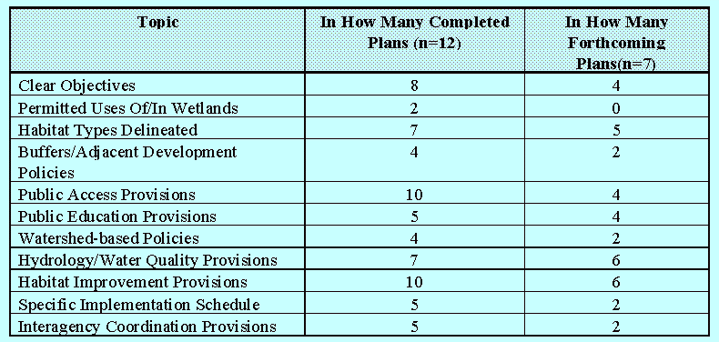
To date, wetland planning has been extensive. Nineteen wetland
plans (some covering multiple wetlands) have been or are being
prepared (and another two are just underway). Eighteen out of
the 25 largest wetlands are covered.[160] However, as Table 5-15
indicates, these plans are far from comprehensive. Out of the
11 noted topics which ReCAP found to be important in managing
cumulative impacts, the average number covered per plan is half
(5.5); with a range from 2 to 11.[161] Having standard guidelines
for wetland plan contents could improve the ability to manage
wetlands.
To achieve solutions to all wetland problems, the planning process requires the participation of affected owners and managers, as well as the public.[162] No one structure appears best for management plan preparation; evaluation of the approaches used to date would be instructive.[163] As noted, wetland plans can result in recommendations for action within watersheds. Conversely, a watershed analysis can lead to wetland recommendations that more comprehensively address cumulative impacts. While logically it would appear that watershed planning should precede (and provide the information base and parameters to) wetland planning, the latter process is currently more advanced and easier to undertake because the geographic scope is typically smaller. At this point, proceeding on both geographic tracks is worthwhile, as long as there is openness to future amendments to ensure consistencies.[164] If a regional framework becomes operational, it could schedule and coordinate future wetland and watershed planning efforts more efficiently.
At the City and County level, land use planning is universal;
but, as noted, its ability to address wetland issues is limited.
In the pilot area local coastal program land use plans were predominantly
prepared in the early 1980's, prior to preparation of most wetland
management plans. As noted, LCPs are not at the level of detail
of subsequent management plans. Local coastal programs for Marina,
North Monterey County and Santa Cruz City, for example, simply
call for preparation of wetland management plans, although lack
explicit criteria for doing so. Santa Cruz City recently amended
its local coastal program to incorporate policies and excerpts
from its completed management plans; Monterey County, on the other
hand, did not.[165] Because many management plans were prepared
pursuant to its enforcement and permit issuance authority, the
Coastal Commission formally reviewed them. Since most were not
explicit components of the LCPs, they have not been amended into
the California Coastal Management Program.[166] Future plans may
not receive Coastal Commission review (or formal review) or local
jurisdictional review unless required as a condition of a locally-issued
coastal permit or to resolve an enforcement action.
The CCMP requires local coastal plans to have land uses, intensities, and locations as well as development criteria that result in wetland resource protection, consistent with Coastal Act Sections 30231, 30233, and 30240. ReCAP found that the region's LCPs generally conform; a few improvements can be made as recommended in this chapter. Subsequent wetland and watershed planning can apply these LCP policy and use parameters, as well as other factors, and arrive at a greater level of detail necessary to address wetland resource issues (as Table 5-15 indicates, many wetland plans to date lack a land/water use component). If a wetland planning process results in recommended land use changes (e.g., decreasing maximum bare ground exposure to prevent sedimentation into a wetland or maximum densities in areas served by septic systems to reduce nutrient loading), then commensurate, follow-up LCP amendments will be required (as well as general plan revisions to cover beyond the coastal zone). Broader structural changes in the CCMP, involving integrating watershed and wetland management planning and implementation within the local coastal program or another process, are worthy of evaluation. This should be undertaken in the context of ReCAP's overall investigation of how the CCMP can address all cumulative resource impacts.
A comprehensive wetland management plan will likely contain a
series of recommendations to address adverse cumulative impacts.
Some of these may address minimizing impacts from new development
(e.g., setbacks, erosion controls) that can be incorporated into
the existing regulatory process. However, other recommendations
may address how to manage existing natural processes and existing
development; for example, recommendations to remove invasive vegetation,
adjust existing tide gates, or sweep streets to prevent polluted
runoff. It will thus be necessary for wetland plans to identify
appropriate authorities and provisions. Since various authorities
may be involved in implementation, they should also be part of
the planning process. As Table 5-15 notes, only 7 out 19 plans
have significant implementation components and interagency coordination
provisions.
ReCAP identified the following complexities that affect implementation of wetland management recommendations in the pilot area: private ownership, multiple ownership, public authorities with competing mandates, extra area authorities, and inadequately constituted authorities.
Private Ownerships:
Many wetlands appear to be at least partially in private ownership.[167] In some cases the owner is knowingly committed to wetland protection (e.g., the Nature Conservancy and the Santa Cruz County Land Trust). In some cases owners have given easements to other entities for management purposes. The extent of other private ownerships engaged in, willing to engage in, or willing to let others engage in protective stewardship is unknown. A logical next step would be to assemble an accurate picture of ownership status (including easement status) and intentions for all of the region's wetlands including their buffer areas. Also, dissemination of general information on private protective stewardship options for wetland owners need not wait for a formal planning process.
Multiple Ownerships and Responsibilities
A second management complexity involves multiple ownerships and
responsibilities. At least 11 wetlands are under multiple ownership
-- some of these involve a mix of public and private holdings.
An example of the management dilemmas encountered with multiple
owners involved Lower Bennett Slough. The Slough is separated
from Moss Landing Harbor North by a road with culverts, which
failed in the 1989 Loma Prieta earthquake. Moss Landing Harbor
is under public trust authority by the harbor district. The road
is owned by the County; the lower Slough, by the Department of
Parks and Recreation and private parties; and the crossing to
the upper Slough, by CALTRANS. Since the proposed repair project
affected the wetland hydrology, all of these ownerships were potentially
affected.[168] After much discussion agreement was reached on
a project that could be adjusted in the future if a comprehensive
wetland management plan is ever developed.
Beyond ownership, many agencies have management responsibilities which affect Monterey Bay's wetlands. These are not necessarily the same agencies with regulatory responsibilities. Even in the case of a single owner undertaking its own project, other agencies may be involved in regulation, funding, and the like. For example, at Laguna Grande, the three primary owners, the cities of Seaside and Monterey and the Monterey Peninsula Regional Park District, united under a joint powers agreement to undertake a restoration project. Five other agencies also played significant roles.[169]
Public Authorities with Competing Mandates
While some wetlands are owned by public agencies and managed for resource purposes (e.g., at least 16 wetlands are owned by the Department of Parks and Recreation and many have been placed in Natural Preserve status), a few portions of wetlands are owned by CALTRANS, Port Districts, or local governments who have placed management under public works departments. These agencies' stated missions (e.g., flood control, transportation) often conflict with resource management objectives. And, in the cases of breaching coastal lagoon mouths mentioned above, the responsible public agencies are other than the actual owners.
Extra-area Authorities
This chapter has documented instances of development occurring outside of, but affecting, wetlands. In the cases of dams on the Carmel, Salinas, and San Lorenzo Rivers, for example, the managing authorities do not own the downstream wetlands.
Inadequately Constituted Authority
As solutions to cumulative impacts are developed, the logical
implementing entities may not exist, may lack authority to fully
carry out the recommendations, or may not be adequately constituted
to perform the required tasks (e.g., may lack staffing, budget,
equipment, training, motivation, etc.). In North Monterey County,
for example, a preventative program is in place to clean up soils
eroded onto roadways so they will not wash into Elkhorn Slough
and then bill property owners for costs. However, program evaluation
discovered that soil is sometimes left on the road and that property
owners are not always billed. The responsible agency operates
the program for traffic safety, not environmental, purposes and
lacks staff time and funding.[170] In Santa Cruz City, the Neary
Lagoon Management Plan presented a series of recreational, water
quality, and habitat management improvements and identified various
city departments with authorities to undertake them.[171] However,
what was missing was an entity with authority to oversee and coordinate
implementation. To remedy this long-standing problem, the plan
recommended creating a coordinator position, which was subsequently
authorized, funded, and filled. In turn that coordinator has engaged
students and volunteers to perform identified tasks that city
departments were constrained in performing.
As each wetland is likely to have different management needs, it will be incumbent upon the development and subsequent monitoring of each plan to identify detailed implementation strategies. In some cases, identifying new or restructured authorities or positions, with proper funding, training, and the like may be necessary.
In conclusion, planning for wetland resources requires an understanding
of the relationship of all the system components and the effects
on them as illustrated in Figure 5-4. It then requires responses
that address all of the topical issues at the appropriate geographical
levels -- wetland, watershed, region, and jurisdiction. Likewise,
knowledge of all the responsible and needed authorities, and a
commensurate implementation strategy is necessary to carry out
planned long-term management and restoration.
Addressing the information gaps in the decision-making process at the project level would also assist comprehensive plan preparation and implementation. Maintenance and use of a computerized, regional database to enable easy access to ownership, management, project status, watershed locations and similar information for each wetland, such as developed by ReCAP staff, would support and further the identified wetland planning initiatives.
With regard to a regional framework:
With regard to watershed management planning:
With regard to wetland management planning:
With regard to management authorities:
ENDNOTES
![]() Go
to the previous chapter,
Chapter 4: Public Access.
Go
to the previous chapter,
Chapter 4: Public Access.
![]() Go to the next chapter, Chapter 6: Information Management.
Go to the next chapter, Chapter 6: Information Management.
![]() Go to the ReCap Pilot
Project...Monterey Bay Region Table of Contents
Go to the ReCap Pilot
Project...Monterey Bay Region Table of Contents
![]() Go to the California Coastal Commission Home Page
Go to the California Coastal Commission Home Page
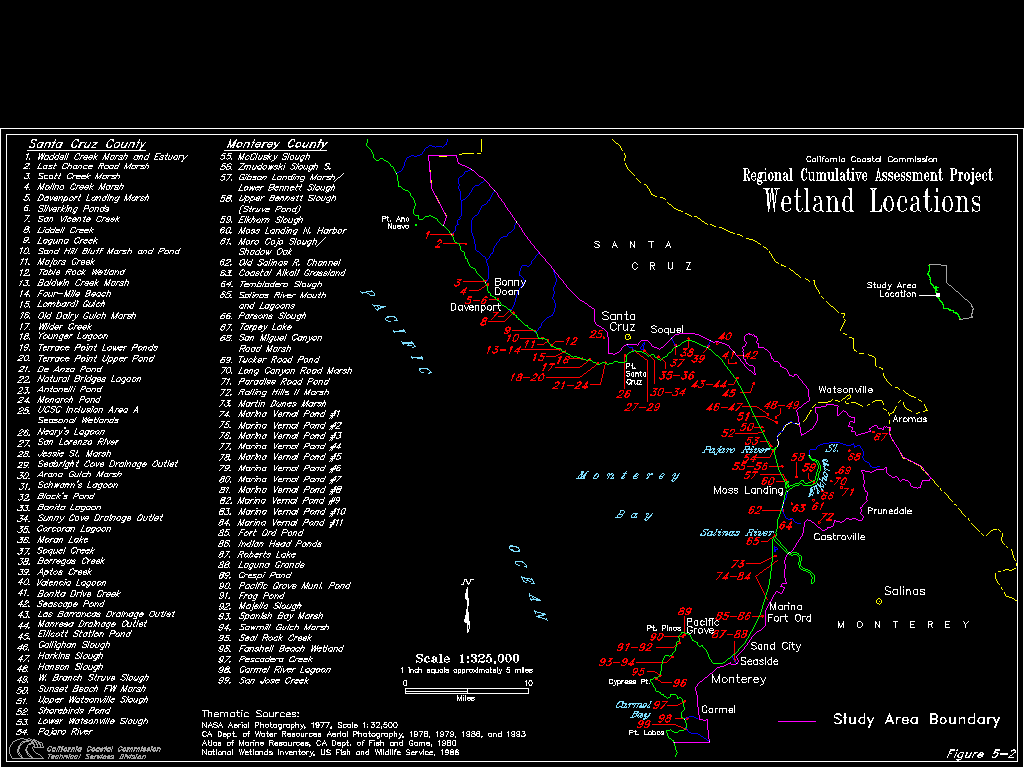
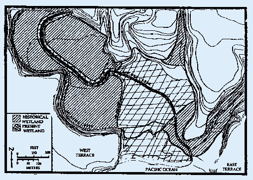
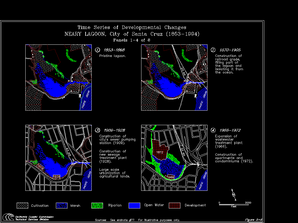
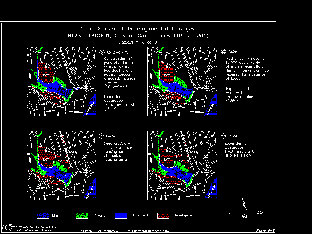
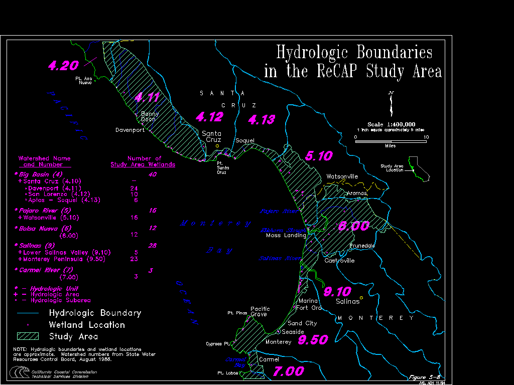
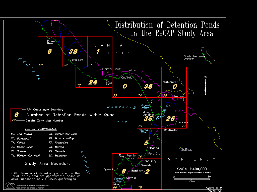