California Coastal Commission
LAND FORM ALTERATION POLICY GUIDANCE
VI. SUBDIVISION EXAMPLES

Parcel on Ridge Top with Steep Slope
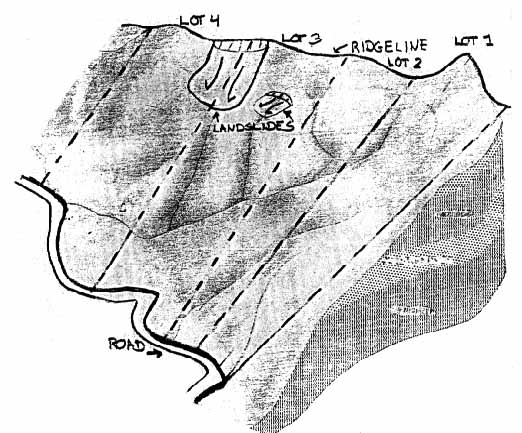
Key Features to Consider in Lot Layout Plans
- Parcel is zoned for 4 single family residential lots (from certified Local
Coastal Program).
- Active fault near site; landslides and landslide prone soils (from Geology
Report).
- Septic systems can be used, but must be kept away from landslide areas
(from Soils Report and certified Local Coastal Program).
- Site disturbance can lead to significant changes on surface flows, erosion
and sedimentation (from Soils Report and Hydrologic Survey).
- Much of the site has slopes over 30% (from topography).
- Site is used as wildlife corridors, portions of the site have sensitive
chaparral habitat (from Vegetation and Wildlife Survey).
- Informal hiking and equestrian trails have been established on the site.
- Main access to site is from existing two lane road bordering one edge of
site.
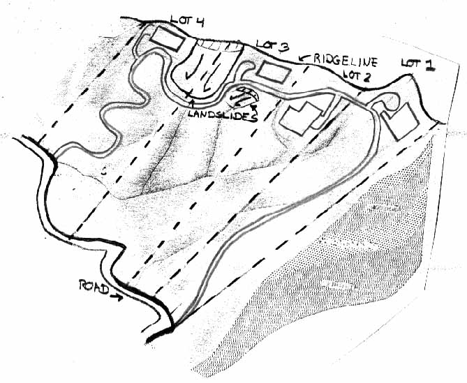
Alternative 1 - Conventional Lot Layout.
|
SITE PLAN CRITERIA
|
COMMENTS
|
- Site Plan Grading and Drainage
|
- No consideration of natural topography or landform.
- Extensive grading required for access roads and all building pads.
- Extensive stabilization required for development.
- Steep ridge topography concentrated in Lots 1 & 2. May need large
buttress fills or retaining walls.
- Slope stabilization efforts and development of access and building pads
will alter drainage.
|
- Access, Circulation and Utilities
|
- 1 main access loop to provide emergency access if one part of road is
obstructed.
- Roads can be used for surface drainage control.
- Extensive grading required for access and clearance.
- Long extensions for utilities, following roadway.
- Septic systems would require setback from slope stabilization and water
lines.
|
- Lot Layout, Buildable Area, Sensitive Resources
|
|
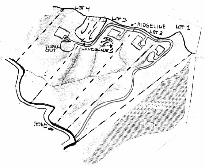
Alternative 2 - Modified Lot Layout.
|
SITE PLAN CRITERIA
|
COMMENTS
|
|
|
- Moderate grading required for access road and private driveways, and less
grading for building pads.
- Natural drainage patterns largely preserved, except where slope
stabilization is required.
- Steep topography concentrated in Lots 1 & 2. May need retaining
walls to develop Lot 1.
|
- Access, Circulation, and Utilities
|
- 1 long access road; toCity/County standards; Locked secondary road for
emergency access.
- Roads can be used for surface drainage control.
- Additional grading and paving for longer driveways minimum 10' width. on
Lots 3 & 4.
- 1 major point of connection with the main road.
- Long extensions of electrical, telephone, water and sewer lines to serve
residences.
- Septic systems would require setback from slope stabilization and water
lines.
|
- Lot Layout, Buildable Area, Sensitive Resources
|
|
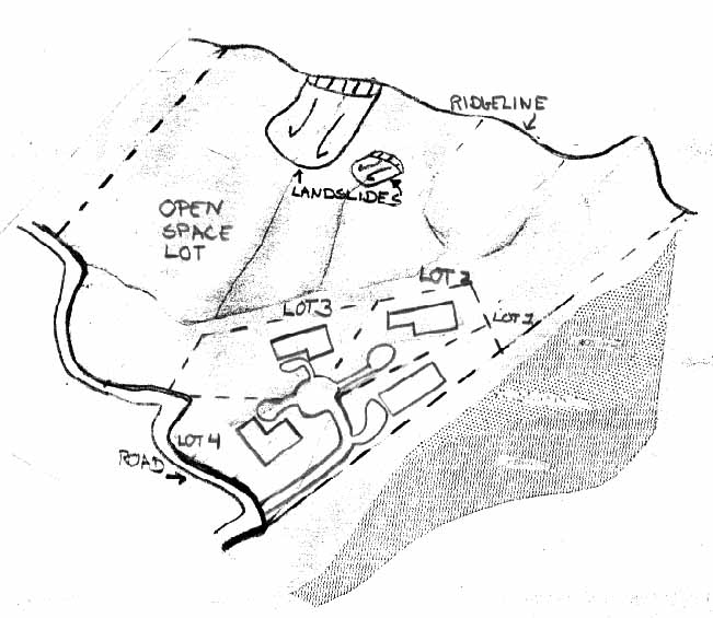
Alternative 3 - Lot Layout with Lot Line Changes.
|
SITE PLAN CRITERIA
|
COMMENTS
|
|
- Development concentrated in small, buildable region of parcel, with steep
slopes and ridgeline preserved in open space.
- Minimal grading required for access road and building pads for all lots.
- No need for large slope stabilization effort of buttress fill; several
small retaining walls are used.
- Natural drainage patterns preserved.
|
- Access, Circulation, and Utilities
|
- 1 main access road to City/County standards; 4 short, private driveways
required.
- 1 point of connection with the main road; no backup access required due to
short length of access.
- 1 main trench to extend electrical, telephone, water and sewer lines to all
residences.
- No limitations for septic systems.
|
- Lot Layout, Buildable Area, Sensitive Resources
|
- Smaller lot sizes, each under 1 acre.
- Minimal grading required for all building pads
- Buildable Llot area approximately equal: All lots approximately 100% level.
- Large open space area provides setback from landslide and sensitive habitat
areas.
- Ridgeline is preserved from development.
|
 Return to Section
6 Table of Contents
Return to Section
6 Table of Contents
Return to Part 2
of Section 6 Parcel on Sand Dune
Return to California
Coastal Commission Publications List
Return to California
Coastal Commission Home Page