
This chapter summarizes ReCAP's investigation of shoreline hazard response -- protection of upland development by armoring, the permitting associated with existing armoring, the impacts from armoring, the policies which address shoreline protection, and the likely changes which will happen to the shoreline in the future assuming existing trends and policies continue. A major finding of this effort is that current coastal policies support the use of public shoreline and public resources to protect private property and if the current situation continues, more and more of the public shoreline will be lost as a public resource. While only an eighth of the ReCAP coastline is now armored, over a third of the ReCAP coastline has the land use and physical characteristics which could require armoring in the future. None of this includes the shoreline already protected by groins, jetties and breakwaters. There are substantial portions of coastline which can be affected by the land use and armoring policies which are in effect.
Most property owners consider shoreline armoring only after they perceive a threat to their development and believe that without armoring, their home or business will be damaged or destroyed. In many cases, the hazards posed by storms and coastal erosion can be serious. Statewide, on average, shoreline hazards cost $100 million annually, either from damage due to storms and erosion, or for shoreline armoring and modification designed to protect against storms and erosion.[1] Breakdown for the ReCAP area is not available; however, a substantial amount of public and private funds are being expended routinely to address coastal hazards.
The ReCAP Coastal Hazards team examined in detail the concerns that: (1) there is no consistent regional approach to address areas prone to shoreline erosion, (2) impacts to shoreline access from armoring are often overlooked, (3) armoring is often put in place during emergency storm events which may have significant impacts to the coast but which has little overall analysis, and 4) the building setbacks for much of the shoreline development in urban portions of the ReCAP pilot area are often inadequate. Examination and analysis of these concerns led to recommendations for improvements in the procedures for developing regular permit conditions, issuing emergency permits, and establishing setbacks. Recommendations also include efforts to introduce a more regionally based plan for shoreline protection. While the recommended changes in procedures could provide some immediate improvement in the management of coastal hazards, longer-term efforts could require changes to Coastal Act policies. The hazards team identified a number of changes and revisions to the Coastal Act itself which could modify or clarify the overall direction for safe development in areas of high coastal hazards. Individually, or in combination, these recommended changes and modifications would provide coastal planners with tools and resources to plan for future shoreline hazards and safe development.
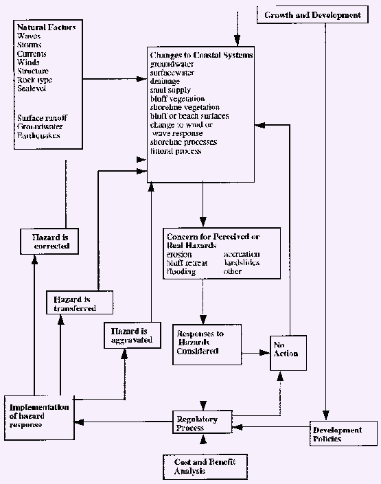
Coastal erosion is a natural phenomenon which occurs along much of the Santa Cruz and Monterey County shorelines. Coastal and upland erosion provides most of the current day beach material. Like other natural processes, such as flooding or earthquakes, erosion is considered a hazard due to the interaction between development and the natural process. ReCAP identified four variables to evaluate the cumulative impacts from policies designed to minimize hazards from coastal erosion: identification of changes to the natural system, recognition of the hazard, determination of responses to the hazard, and assessment of the costs and benefits of the responses including determination of changes to the natural system resulting from the response. Figure 3-1 is a conceptual model for coastal hazards which outlines many of the components of coastal hazards and identifies their interactions.
Figure 3-1: Hazards System Diagram Sources of Impacts to Hazards. Click here to view Figure 3-1.
The California Coastal Act (Coastal Act) is a major, state-wide law establishing a regulatory program that governs coastal hazard response, development along the shoreline, and the use of shoreline armoring. The major Coastal Act policies which address coastal hazard response are found in the following sections: Section 30253 which addresses the overall stability of new development; Section 30235 which provides for protection of existing development along the shoreline when it is threatened by shoreline erosion; and Section 30610 regarding the rebuilding of existing development that has been destroyed by a natural disaster. These three sections give somewhat conflicting direction regarding response to coastal hazards and reliance on shoreline armoring. Section 30253 sets standards that require that new development:
(l) Minimize risks to life and property in areas of high geologic, flood, and fire hazard.
(2) Assure stability and structural integrity, and neither create nor contribute significantly to erosion, geologic instability, or destruction of the site or surrounding area or in any way require the construction of protective devices that would substantially alter natural land forms along bluffs and cliffs. (Emphasis added)
This policy has been the basis for requiring technical reports (geologic reports, wave run-up analysis, slope stability or site inundation studies, to name a few) for new development in areas of high hazard to ensure that the proposed project, as designed, can be relatively safe over its lifetime. The Coastal Commission and most of the Local Coastal Programs (LCPs) in the pilot area address the safety of new development along coastal bluffs through setbacks which require that the new structure be a sufficient distance from the edge of the coastal bluff that the structure will not be threatened by bluff retreat or natural erosion during the life of the structure. The Commission provides for use of setbacks through inclusion of suggested setbacks in the Statewide Interpretive Guidelines. At the local level, setbacks are provided by detailed discussion in the LCPs. Most LCPs in the ReCAP area require that setbacks be sufficient to protect the structure for a 50 year economic life and require a minimum setback distance based on either site-specific geology reports or use of the Area of Demonstration.[2]
One requirement of Section 30253(2) is that new development should be stable without the construction of protective devices to minimize hazards. However, once a new structure has been built, it is an existing structure and Section 30235 of the Coastal Act permits existing structures to use shoreline armoring to protect against shoreline erosion. Some permits for new development have included conditions which make clear that the development was approved only with the understanding that shoreline armoring would never be needed. Section 30235, applied to most existing development, states in full:
Revetments, breakwaters, groins, harbor channels, seawalls, cliff retaining walls, and other such construction that alters natural shoreline processes shall be permitted when required to serve coastal-dependent uses or to protect existing structures or public beaches in danger from erosion, and when designed to eliminate or mitigate adverse impacts on local shoreline sand supply.
Existing marine structures causing water stagnation contributing to pollution problems and fish kills should be phased out or upgraded where feasible. (Emphasis added)
All the LCPs for the pilot area, in conformance with the Coastal Act, allow shoreline armoring where it is necessary to protect existing development, coastal dependent uses or public beaches. While the pilot area LCPs all take a fairly similar regulatory approach to stability of new development, the pilot area LCPs have several different approaches to the review and regulation of protection for existing development. All LCPs require that an application for a shoreline protective device be supported by technical or geologic reports; several jurisdictions encourage the use of rip-rap whenever possible and allow vertical walls only when rip-rap cannot provide adequate protection or when there are seawalls on adjacent properties. The City of Santa Cruz allows seawalls at the toe of a seacliff only when all other alternatives are infeasible. The City of Capitola allows shoreline protective devices only if non-structural alternatives are infeasible. Other localities establish some performance standards for shoreline protection, such as minimizing impacts on sand supply or to public access, but do not provide guidance as to the preferred armoring type. The different approaches used in the LCPs reflect some of the differences in shoreline hazards and responses to these hazards which exist throughout the ReCAP pilot area.
Section 30610 of the Coastal Act indirectly addresses protection of shoreline development through the reconstruction of structures that have been destroyed by natural disaster. The policy provides that if the replacement structure is in the same location as the destroyed structure and not more than 10% larger or higher than the destroyed structure, no coastal development permit (CDP) is required for the replacement structure. If the replacement structure will be further back from an eroding bluff or higher above the flood elevation than the destroyed structure, the replacement will not be exempt and a CDP must be obtained. While an intent of this policy is to prevent permit delays following a disaster event, its implementation may have cumulative impacts by precluding the examination of risk reducing alternatives. In cases where seawalls have been destroyed by natural events, this policy may perpetuate the reliance on an inadequate seawall design; in cases where bluff top structures have been destroyed by storms, this policy may perpetuate the use of inadequate setbacks. If the permit process is the only mechanism for an analysis of the stability of the replacement structure, property owners can rebuild without any analysis of the future risks of such activity.
The City of Santa Cruz, the County of Santa Cruz, and the Carmel area LCPs have policies addressing reconstruction of structures destroyed by natural disaster. The other LCPs in the ReCAP area do not give any guidance on how such projects will be handled. The City of Santa Cruz and the Carmel Area LCPs follow Section 30610 completely and the County of Santa Cruz LCP bases the requirements for reconstruction on the value of the losses. If the losses exceed 50% of the value, the reconstruction is treated the same as new development, requiring a technical report and deed restriction. (Such reconstruction does not have to demonstrate long-term stability without shoreline protection, as would be required were Coastal Act Section 30253(2) to apply).
In general, the guidance provided by the Coastal Act and LCP policies relating to shoreline armoring is to try to site new development to avoid the need for any type of protective device; however, if development is threatened by erosion, shoreline armoring will be allowed to protect the development, with efforts made to minimize the impacts from the protection. In terms of reconstruction policy, except for those areas covered by the Santa Cruz County LCP, if the hazard is sufficient to actually cause damage to the development, a similar structure can be rebuilt in the same location without a CDP; however, relocation or redesign for greater safety would likely require complete review and a CDP. These policies together have established a long-term reliance on shoreline armoring to protect private and public development.
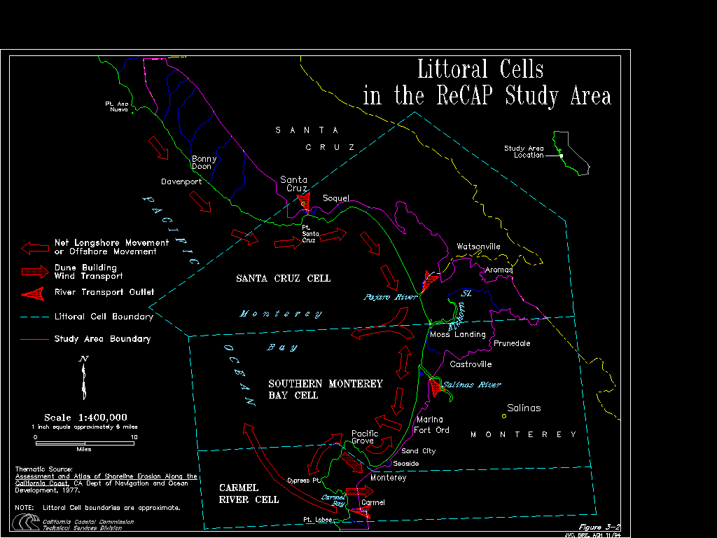
The pilot area, from the San Mateo/Santa Cruz county line south through Point Lobos in Monterey, offers a variety of shoreline types and is an excellent area to examine the concerns of cumulative impacts of shoreline erosion and responses to erosion. There are three separate littoral cells within the pilot region, shown in Figure 3-2. The shore characteristics range physically from beaches and dunes to lagoons and steep granite cliffs; the upland uses range from low and high density residential and commercial to parks and agricultural lands.
Figure 3-2: Littoral Cells, ReCAP Study Area.Click here to view Figure 3-2.
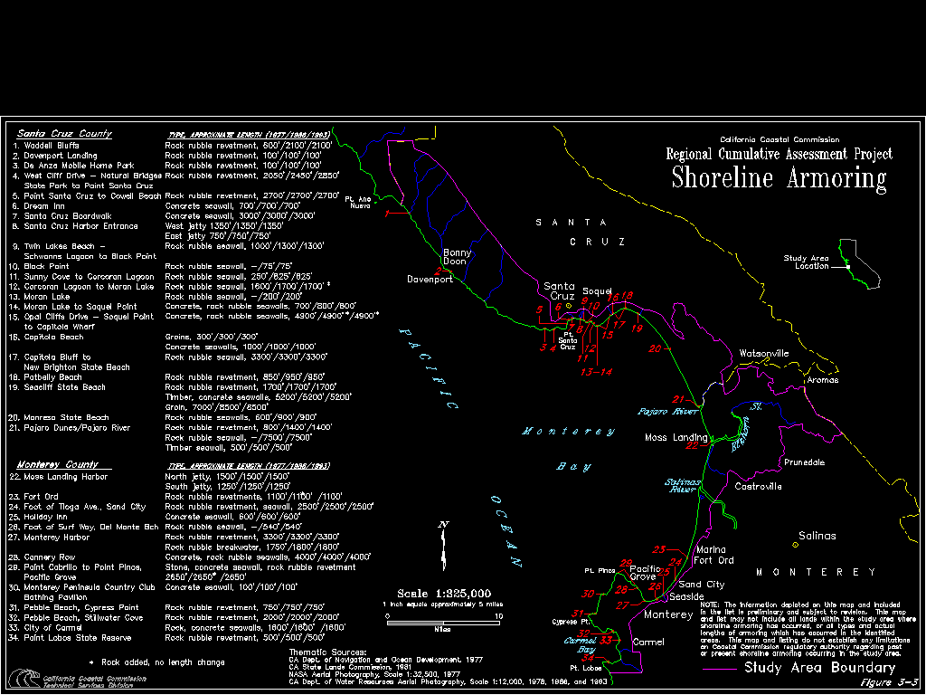
Figure 3-3 shows the locations of shoreline armoring throughout the ReCAP pilot area, based on a review of aerial photographs from 1978, 1986 and 1993. Due to the cost of, and impacts from, armoring, it is rarely undertaken in areas where there is not now or has not been a pressing need for protection. As can be seen from Figure 3-3, armoring has concentrated mainly in those developed areas which combine highly erosive shoreline material with a high instance of storm wave attack. The section of coast from Corcoran Lagoon to Soquel Point, for example, is completely armored except for one small lot, approximately 60 feet wide.[3] Areas where the shoreline material is very resistant to wave erosion and areas which have some natural protection from storm waves have had very little armoring activity.
Figure 3-3: Shoreline Armoring, ReCAP. Click here to view Figure 3-3.
There has been an historic demand for shoreline protection throughout the ReCAP pilot area, beginning in Santa Cruz County. In 1971, the U.S. Army Corps of Engineers (ACOE) undertook an inventory of the California shoreline and found approximately three miles of armored shoreline in the ReCAP area, all located in the City of Santa Cruz from Natural Bridges to Soquel Point. Small areas south of this were armored, but the amounts were too little to tabulate.[4] The ACOE did not identify any protection in Monterey County. As part of the ReCAP analysis, aerial photographs of the pilot area for 1978, 1986 and 1993 were examined for armoring. This review differed from the work done by the ACOE and, without knowledge of the techniques used by the ACOE, the results can not be compared quantitatively; nevertheless, a qualitative comparison shows substantial increases in the amount of armoring throughout the ReCAP pilot area between 1971 and 1978.
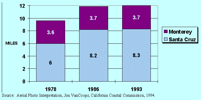
As shown in Figure 3-4, by 1978, there were approximately 9.6 miles of armoring in the ReCAP area -- 6 miles in Santa Cruz County and 3.6 miles in the ReCAP portion of Monterey County. By 1986, a total of 11.9 miles were armored, with 8.2 miles in Santa Cruz County and 3.7 miles in the ReCAP portion of Monterey County. By 1993, additional armoring in Santa Cruz County increased the amounts of armored shoreline to 8.3 miles for Santa Cruz County and 12 miles for the entire ReCAP area. None of these estimates include lengths of beaches protected by breakwaters, jetties or groins, nor do the figures for length reflect the maintenance and additions of rock to existing walls. Much of the increase in armoring between 1978 and 1986 is thought to have been constructed in response to the storms in the late 1970s and early 1980s.
Figure 3-4: Shoreline Armoring in the ReCAP Region, 1978, 1986 and 1993
Almost all of the shoreline protection in the ReCAP area is provided by rip-rap or rock rubble revetments, with only about 1.1 miles of protection from concrete or timber seawalls without rock. Rock is often less expensive than a vertical wall and is considered by many to be more "natural" looking -- possible reasons for the preference given to rip-rap by some of the LCPs in the ReCAP pilot region. However, rock takes up much more land or beach area than a vertical wall and, when constructed on a public beach, can replace area used for access and recreation. In some locations in the ReCAP area, access to shorefront property is so difficult that the shoreline protection design is more dependent on the means of placing the structures than on the coastal characteristics.[5]
ReCAP staff undertook a review of aerial photographs and land use plans to identify potential areas of future growth and shoreline armoring in the pilot area. Much of the shoreline land within the urban service areas has been developed and the only areas with a significant amount of vacant urban shoreline are Sand City, Marina, and Del Monte Forest. In both southern Santa Cruz County and northern Monterey County, there are large holdings of shoreline property that are zoned agricultural. Some of the agricultural lands have levees for protection from flooding but none now have any seawalls or revetments for protection from erosion. This is likely to continue since erosion seems to be small in many of the areas of agricultural land and armoring for a large agricultural parcel would be very expensive. Unless there is major rezoning of agricultural shoreline lands, the key shoreline hazard concerns in the pilot area will come from repair and maintenance of existing armoring and new armoring to protect either existing development or new development on infill lots.
From this rough review of existing land use patterns and shoreline characteristics, the ReCAP team estimated that up to a third of the entire ReCAP area shoreline, combining developed or developable land, has a significant rate of erosion. If current armoring practices continue, ultimately as much as 19.3 miles of the Santa Cruz County shoreline and 8.4 miles of the ReCAP portion of Monterey County could be armored to protect either private development or public works and infrastructure (including development immediately landward of public beaches as has happened in the Live Oak area of Santa Cruz County for protection of East Cliff Drive). This would more than double the length of armoring that exists in the ReCAP area today.
Just as the examination of the shoreline conditions over time shows increases in armoring in the pilot area, a review of the permit activity in the ReCAP area from 1983-1993 shows approval of numerous permits for shoreline protection. Many shoreline protection projects were revised during the permit review process, and many projects had conditions attached to the approval to mitigate impacts; one project was initially denied but after several appeals was approved with conditions. One hundred shoreline protection permits were approved for the ReCAP region during this time period: 4 for beach nourishment projects and 96 for some form of seawall, bulkhead, revetment, or cave filling. All four beach nourishment projects were approved by the Commission and were associated with dredging projects.[6] Of the 96 armoring projects, 79 were approved by the Commission and the remaining 17 were approved by ReCAP area local governments.[7]
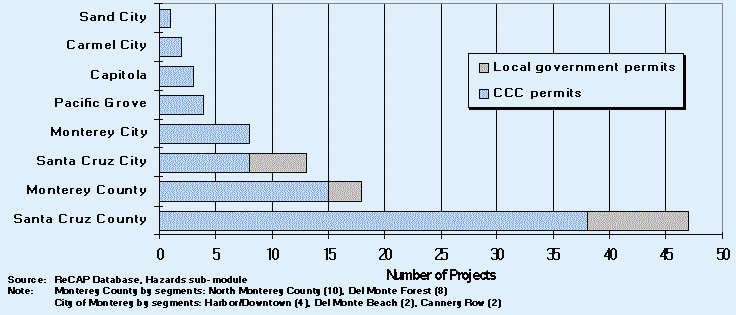
Figure 3-5 shows the geographic location of the approved armoring projects. The majority of approved seawall projects from 1983-1993 have taken place in the northern portion of the ReCAP pilot region. The permit database indicates that 47 seawall projects were in the Santa Cruz County LCP jurisdiction alone. When the approved seawalls in the Capitola and Santa Cruz City LCP jurisdictions are summed with those in Santa Cruz County (representing all approved seawall activity along the Santa Cruz County shoreline), nearly 66% of all seawall project activity in the ReCAP pilot area was located in the northern portion of Monterey Bay.
Figure 3-5: Approved Seawall Locations by LCP Jurisdiction, ReCAP Region 1983-1993
The shoreline protection placed as a result of the 100 approved permits from 1983-1993 was primarily a response to private development interests: 59% of the approved projects were to protect private residential, commercial, or industrial development, 15% to protect institutions or harbors, 21% to protect public works or public recreation interests, and the remaining 5% to protect some other type of development.[8] While 30 of the 96 armoring permits were approved for new seawalls or revetments, 63 were for some form of repair, maintenance, or expansion to an existing shoreline structure and 3 projects were unclear as to their associated activity. One reason for the high number of permits involved with modifications of existing structures is that most of the armoring in the pilot region is made up of rip-rap revetment which requires regular additions of rock for the structure to function effectively.
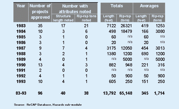
Table 3-1 identifies some cumulative effects of the armoring that have been permitted from 1983 to 1993 -- many of the activities that have contributed to the current 12 miles of armored shoreline. Table 3-1 also shows the lengths of the approved seawalls as well as tons of rip-rap placed over the time period of 1983-1993. Unfortunately, complete records of lengths and tonnage were not readily available. Of these 96 projects, 40 had some length recorded and 38 had some tonnage of rip-rap recorded. Using the cases where these project attributes were noted, totals and averages overall as well as for respective years are presented. It is clear that the permit activity following the 1983 storms accounts for the majority of armoring activity, making over 50% of the noted length and over 40% of the rip-rap tonnage. Overall, more than 2 miles of approved seawall activity and over 65,000 tons of approved rip-rap were identified in the ReCAP area from 1983 through 1993. (Since these values were developed from only a portion of all the permits approved from 1983 to 1993, actual lengths and tons will be higher). On average, where project attributes were noted, a typical approved ReCAP pilot area armoring project involved 345 linear feet of coastline and 1,714 tons of rip-rap; further breakdown shows that for private development in the form of residential, commercial, or industrial uses, a typical average project was slightly smaller at 227 linear feet and 1205 tons of rip-rap.[9] Since many of the residential applicants applied as groups, these figures do not reflect averages for individual residential parcels.
Table 3-1: Shoreline Armoring Permitted in the ReCAP Region, 1983-1993
Future demands for shoreline protection will depend on trends in development along the shoreline, erosion potential of the shoreline, and frequency of storm events. It is not possible to graph historic demand and extrapolate since the conditions that establish the demand will continue to change. ReCAP's predicted trend for future armoring was based on assumptions regarding the amounts of development which may be threatened in the future by erosion. In Santa Cruz County, 19.4 miles of upland shoreline are privately owned and 17.8 miles are publicly owned; in the ReCAP portion of Monterey County, approximately 16.3 miles of upland shoreline are privately owned and 24.5 are publicly owned. In the total ReCAP area, there are 35.7 miles of shoreline which have been or may be developed with private upland development, and much of this has required, or eventually may require, shoreline armoring.
A study by the ACOE provides a second identification that new portions of shoreline may be armored in the future. As part of a study on shoaling at Santa Cruz Harbor,[10] the ACOE studied the section of Santa Cruz coast from Seabright Beach to New Brighton State Beach for shoreline geology, status of existing protection and current hazard level from erosion. Although large stretches of this 4.8 miles of coast have been armored, the study identified several areas where continued erosion can be expected to endanger development and structures in the future. If the shoreline is unprotected or has inadequate protection and the historic erosion rate is moderate or high, the study identified the area as liable to need future protection. Based on this screening effort, 1.9 miles of coast were considered in need of future protection. Of these 1.9 miles, 0.7 miles would be required to prevent road closures or relocation of utilities and 0.4 miles would be required to protect homes or apartments from erosion; almost 0.8 miles would be to protect vacant coastal land. Some of the proposed protection were efforts to restore the functioning of the natural groins at Pleasure Point and Peeper's Beach, enhance the beach building ability of these areas, enhance recreational opportunities and add 82,500 square feet of beach total;[11] no estimates were made of the recreational losses which would result from the encroachment of 1.9 miles of seawalls and revetments.
Many coastal areas contain a variety of shoreline protective devices. There is little attempt, in most cases, to design shoreline armoring to address regional resources or constraints. Adjoining properties, with similar wave climate and geology, have a variety of protective 'solutions' all represented to be appropriate to the site. The only review for protective structures provided by the Coastal Act is that the structures be "designed to eliminate or mitigate adverse impacts on local sand supply" (Section 30235); no regional consistency is required.
In the ReCAP area, the geology of certain "regions" varies considerably. Geologic conditions for the coast of Santa Cruz County include a moderately resistant mudstone in the northern cliffed areas and sedimentary formations of sandstone and siltstone in the southern portion. Monterey County's north coast consists of mostly beach and dune features -- relatively young dunes such as the Marina Dune complex, as well as older dunes such as the inland portions of the former Fort Ord military reservation. The southern portion of Monterey County's coastline consists of mostly resistant granite rock with interlying sandy pocket beaches. Generally in the Monterey Bay pilot area, with the exception of few specific localities, the coastline is eroding, losing large quantities of sand naturally to the offshore submarine canyons and some to the inland dune systems.
While the ReCAP pilot area offers a variety of shoreline types, many smaller portions of the shoreline have common features. Segments of the bay's shoreline may be broken down into "regions" while considering such factors as geology, wave conditions, and natural sand budget, to name a few. At a large scale, the shoreline can be divided into littoral cells which share common characteristics of sediment sources and transport. On a smaller scale, there are stretches of coast bounded by lagoons or headlands which have a similar geology and wave climate. These common factors should affect the types of armoring which will be most effective for a portion of shoreline; however, in many portions of the ReCAP area, the strategies used to provide shoreline protection differ greatly from one property to the next, in spite of the apparent physical similarities between the sites.
Shoreline protective measures in portions of the ReCAP pilot area generally lack any regional scheme for dealing with erosion. For example, in many coastal permits for projects within Santa Cruz County, geologic analyses often consider regional wave conditions and/or tectonics, but rarely do these reports consider sand budgets or regional sand supplies. Santa Cruz Harbor was constructed before the Coastal Act came into effect and thus it never received review through the California Coastal Management Program (CCMP); however, this project illustrates both the regional effects which can accompany a single project and the importance of a regional overview of projects which may modify shoreline processes. Since the harbor has been constructed, an expansive beach has developed upcoast of the jetties where there once had been significant erosion; downcoast areas as far as Capitola have experienced profound decreases in sand supplies and increased shoreline retreat. Since construction of the harbor, there have been at least six regional studies investigating ways to address these downcoast effects.[12]
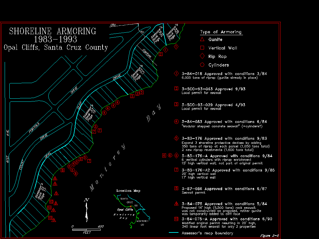
The Live Oak area of Santa Cruz County illustrates a second situation which can arise when individual projects are undertaken without a regional overview to guide shoreline activity. Much of the shoreline has been armored; numerous protective efforts exist in close proximity to each other and review of permit activity shows repeated activity at some sites. Figure 3-6 shows a mosaic of permit activity for one small section of coast within Live Oak along Opal Cliffs. This plethora of armoring and permit activity makes comprehensive review difficult -- work has been done through the emergency process, through regular Commission issued permits and through local permits. Within this 3,000 foot long section of shoreline, properties have been protected with gunite, vertical walls, rip-rap and concrete cylinders. Some properties were issued two or three permits for different armoring activities, properties received permits for one type of protection and different armoring was actually constructed, new properties have been added to existing permits through the amendment process, and several properties received local permits without any conditions for access.
Figure 3-6: Opal Cliffs Up Close and Personal. Click here to view Figure 3-6.
A regional overview of this segment of coast could have identified the major factors contributing to erosion and identified an effective strategy for the "region" to address natural shoreline processes. Such an overview might identify recommended treatments for various areas, such as where revetments may be most effective, areas where vertical walls may be most effective, areas where surface treatment of the bluff (gunite, rock bolting, etc.) may be most effective, and finally, areas where beach nourishment or sand management may be most effective. Applicants could use this general direction to design a site-specific solution. As a second type of regional overview, some local governments have prepared "standard" designs for shoreline protection which can be used in specified areas.[13] Applicants can use these designs in the specified areas or identify different efforts for protection which better suit the site-specific conditions.
The existing situation in Live Oak, however, presents a piecemeal confusion of protective measures. From an engineering perspective, the weakest points in shoreline armoring are normally the ends and the junctions between different styles of protection (rock adjacent to concrete to gunite, for example). Such ends and junctions occur frequently in the Live Oak area, and while no engineering evaluation has been prepared, the potential for weaknesses in the protection would be greatly reduced by a regional approach to controlling erosion in the area. In addition, the general look and aesthetic of the area would change if adjoining properties had shoreline protection efforts with a similar visual effect.
A final support for a regional overview of shoreline activity comes from an earlier analysis of coastal hazards by Gary Griggs, James Pepper and Martha Jordan, in which they find,
Since these decisions are usually made on a project-by-project basis, they tend to be evaluated independently, without any systematic consideration of the aggregate or cumulative effects either within or among jurisdictions. Within such a decision-making context any given project can be viewed as small and thus easy to rationalize in terms of approval. Cairns (1986) calls this endemic failure to take into account the aggregate effects of environmental management "the tyranny of small decisions".[14]
A regional overview for individual shoreline activity would provide coastal planners and analysts a perspective on how an individual project would fit into the overall cumulative approach to shoreline management.
Without a regional overview, the piecemeal approach to shoreline protective devices will continue to impact shoreline processes and resources. The attempt to minimize coastal hazards with various devices (seawalls and numerous rip-rap structures), combined with naturally occurring coastal processes, requires a closer examination of their cumulative impacts. Piecemeal solutions to coastal erosion problems are not generally effective and have the potential to create further problems. Often overlooked are the regional effects of such shoreline protection. Where a regional coastal erosion problem exists, a regional solution should be developed and implemented.
The ReCAP pilot area has had many years of experience with a variety of armoring devices. It should be possible to study the on-site impacts, possible downcoast impacts and maintenance records for these structures and determine which types are most effective in different areas. From such information, local governments would be able to make sound decisions about the types of armoring which would be allowed in the future.
Incremental impacts to beach areas, access and the general character of the shoreline have occurred from approval of permits for shoreline armoring. Over the ReCAP time period, there have been measurable losses in beach access through increases in the length and area extent of shoreline armoring, but many permits have been approved without any conditions directed at access impacts.
Public access concerns are not always addressed in permits for
shoreline armoring. Review of approved shoreline armoring in the
ReCAP region from 1983-1993 identified that many projects raised
some access issues, such as blocking or encroaching on lateral
or vertical access, but not all such permits contained access
mitigation: 8 of the projects involved some type of improvement
to access facilities, and no access mitigation was needed with
the project; 36 projects were required, through conditions, to
improve access either through an easement, dedication, or improvements
to access facilities; 45 projects had no permit conditions requiring
mitigation of access impacts, but the information in the ReCAP
database was not of sufficient detail to determine the types or
extents of access concerns which were raised by these projects.
It is likely that many of these permits with no access related
condition were for repair and maintenance of existing structures.
For such permits, the access concerns were likely to be the perpetuation
of impacts resulting from the original structures; the major impacts
to access would have resulted from the initial construction and
would have been addressed in the original permit action, if the
structure was built during the time of the Coastal Act. However,
if any of these projects were for new structures or the physical
expansion of existing structures, they would have added new constraints
to access which should have been considered. Since access impacts
from shoreline armoring can be significant and long-term, when
access issues are raised by a project involving shoreline armoring,
the individual and cumulative impacts to access should always
be addressed.
Much of the pilot area coastline has been developed and over 12
miles have been armored, as of 1993. As noted earlier in Figure
3-3, portions of this armoring occurred prior to the Coastal Act,
LCP certification and the time frame for the ReCAP study. Assuming
that a vertical seawall extends 4 feet onto the beach and revetments
or rubble walls extend 20 feet onto the beach, the existing 12
miles of armoring occupies over 1 million square feet or 25 acres
of beach, not including other beach level development, such as
homes, which occupy the protected beach (for example, the development
at Seascape). If, as projected, 35.7 miles of shoreline may eventually
rely on shoreline armoring for erosion protection, the loss of
beach area could increase to 65 acres. Even with the inclusion
of mitigating lateral and vertical access dedications where appropriate,
clearly the loss of recreational access will be severe.
Shoreline armoring alters the shoreline and shoreline processes
in several ways. An immediate and noticeable effect will be the
physical encroachment or occupation of the shoreline as mentioned
above. If a section of beach is covered by revetment rock, the
beach is no longer available for beach access. A trail may be
developed on top of the revetment, and while there may be great
benefit from such a trail, the access opportunity would be different
than that which had been provided by the beach area.
A more long-term impact from armoring will be its interference
with long-term shoreline retreat. A primary function of well designed
shoreline protection is that it protect upland development by
halting or slowing future landward migration of the backshore.
If the seaward edge of the beach continues to erode, the available
beach width will become more and more narrow and will eventually
disappear. Waves will run up on the revetment or to the toe of
the seawall and all beach access will be eliminated. Finally,
if the back beach area is a source of sand to the littoral system,
efforts to armor the back beach will prevent this material from
reaching the littoral zone and nourishing beach areas downcoast.
Thus, armoring can alter access opportunities in a number of ways.
A large amount of shoreline armoring in the ReCAP pilot area has been put into place under "emergency" circumstances, either during or immediately following storm events. The emergency process allows for this armoring to take place with little regulatory review of the project, such as would be required through the standard permit process. Without this project review, shoreline protective devices are created and/or altered with:
The ReCAP database showed that many of the issued armoring permits
were emergency permits, many in response to the 1982/83 storms.
Out of the 96 armoring permits, 24 (or 25%) were emergency permits;
5 new shoreline protective devices were permitted through the
emergency process and 19 existing structures were maintained.
Eighteen of the 24 emergency permits were issued during the severe
1983 storms, with many issued directly in the field.[15] All 24
emergency permits were issued by the Commission, so nearly one-third
of all Commission-issued armoring permits were issued as emergency
permits. These same 24 emergency projects resulted in at least
24,000 tons of additional shoreline armoring.[16]
Section 30611 of the Coastal Act states that the intent of emergency
permits is to allow a rapid, non-permanent response "to protect
life and public property from imminent danger." Section 30611
concludes with the limitation that it does not "authorize
permanent erection of structures valued at more than twenty-five
thousand dollars ($25,000)." Unfortunately, there are few
inexpensive, temporary "stop-gap" measures for shoreline
erosion and storm protection, and in most situations the emergency
action ends up being a permanent structure.
Once the critical nature of an emergency situation has been recognized,
emergency requests are generally granted due to concerns over
public safety. While emergency permits usually require follow-up,
regular permits to ensure detailed technical review and allow
the incorporation of conditions for monitoring, maintenance or
mitigation of impacts to public access, only a few of these emergency
permits had associated regular permits.[17] It is the formalizing
CDP process that would allow for the standard regulatory scrutiny
of the project which, in turn, would provide technical analysis
of the structure, analysis of non-structural alternatives, and
mitigation of impacts to public shoreline resources. Many of the
emergency permits were repair and maintenance waivers for existing
shoreline protection permitted prior to the time period assessed
by ReCAP; therefore, although those regular permits did not appear
as part of the ReCAP database, they would serve as the associated
regular permit to the emergency permit.
Emergency armoring projects in the pilot area have typically occurred
in high hazard areas that have a high likelihood of storm driven
events reoccurring in the future, leading to an ongoing "emergency
cycle". For example, in the Live Oak/Opal Cliffs area, an
area of known high hazard and extreme erosion, over 40% of all
recent armoring permits have been approved through the emergency
process.[18] Live Oak/Opal Cliffs is discussed in Hazards Problem
#1 and Figure 3-6 as an example of an area with little coherent
approach to armoring; within approximately 3,000 feet of beach,
there are four distinct approaches to armoring and several spots
where two or three protective measures have been tried, one on
top of or in front of the other. In the absence of defined regional
hazard management plans, the shoreline armoring put in place with
an emergency permit will typically result in haphazard placement
of protective materials in the specific geographic locations that
are most in need of sound shoreline protective devices.
Some emergency permits were to add rock to existing revetments.
Such actions, in non-emergency situations, would be considered
routine repair and maintenance. These projects would require only
baseline technical review and engineering rather than detailed
technical review and evaluation of alternatives. For a variety
of reasons it seems that many property owners postpone maintenance
until a storm event. Emergencies are the worst time to undertake
proper and effective maintenance since the size and amount of
rock may be dictated by availability rather than engineering design
and the locations which are protected will be those which are
easy to reach. Normally, these areas do not receive any more attention
until the next emergency. Regular permit follow-up for these "emergency"
situations could plan for future inspections and maintenance needs
and break the cycle of crisis-based shoreline management.
The areas of high hazards that are currently susceptible to shoreline
erosion and high wave impact are expected to continue to be the
hardest hit by both episodic storm events and long term erosion.
Without any regional shoreline planning prior to the emergency
situation, these same known hazardous areas will continue to see
a collection of individual responses to what is essentially a
regional issue. The less "costly" emergency process
(minimal filing requirements, expediency of review, minimal project
analysis, lack of required mitigation, etc.) encourages an emergency
response, so, absent program changes, large amounts of armoring
will continue to be put in place through the emergency process.
The end result is short-term protection of individual properties
in a manner that may not have been analyzed for technical adequacy
or for impacts to coastal access.
Concern about the use of the emergency process is not unique to
the ReCAP area. One of the key recommendations from the coastal
hazards study by Griggs, Pepper and Jordan was to strengthen the
policies governing emergency protection projects.[19] Statewide,
there is no consistent follow-up of emergency actions nor assurance
that emergency actions will either be upgraded for permanent protection
or removed following the emergency.
The main issue for the processing of emergency shoreline protection
permits is one of ensuring that there is adequate review of the
proposed project in terms of alternatives, technical analysis,
and public beach access, while accommodating the time constraints
inherent in an emergency situation. The emergency permit process
needs to, as much as possible, agree with and complement the review
and analysis available through the regular permit process. The
emergency process must be improved to ensure standard review of
the project after the immediate crisis has ended. As part of a
longer term effort, the mechanisms for an emergency process should
be included in comprehensive regional hazard plans that would
define emergency situations, outline acceptable designs and responses
for emergency shoreline protection and develop detailed review
steps for foreseeable emergency actions.
Setback distances incorporated into shoreline development approved in the ReCAP pilot area are not adequate in all cases to protect structures over the course of their lifetimes without the introduction of a hard protective device. Furthermore, the determination of "adequate" setback distances, relying greatly upon erosion rates that often overlook episodic erosion, does not always result in adequate long-term setbacks. This problem is particularly evident in high hazard areas that are already partially or substantially developed.
Throughout the ReCAP pilot area, the LCP policies use bluff top
setbacks or shoreline setbacks in an attempt to ensure that new
development will be at minimal risk from erosion, storm waves
and bluff retreat. Typically these setback distances for ReCAP
area LCP jurisdictions make use of a 50 year economic lifetime
setback, often established as 40 or 50 feet from the bluff edge
or beyond the point of maximum wave run-up, with provisions for
allowing smaller setbacks if geologic conditions so warrant.[20]
Structural setbacks are meant to minimize risk from these hazards
by allowing natural processes to take place without threatening
any structures on the subject property. The idea is that if the
structures are far back from the shoreline, natural erosion and
storm events will not adversely impact them and shoreline protective
devices will not be necessary during the lifetime of the structure.
Unfortunately, setbacks do not address risk to all structures
since setbacks can only minimize risk on a lot large enough to
accommodate both the necessary setback and the development. Also,
setbacks do not minimize risks to existing development, to new
development on lots too small to accommodate both a safe setback
and development, or to any development which lasts longer than
its theoretical economic life.
Setbacks are generally determined by an analysis of erosion rates
along the coast; unfortunately, erosion rates can be somewhat
elusive. Among the numerous factors influencing erosion rates
(e.g., regional wave conditions, geologic conditions, sand budgets,
and structural development), one of the least understood and applied
is episodic storm events. Coastal engineers recognize the episodic
nature of shoreline erosion; however, most setback regulations
are developed assuming steady, incremental erosion. While average
annual seacliff erosion rates in the ReCAP pilot region are commonly
calculated at about one-half to one foot per year, these rates
must take into account episodic events that may or may not have
been recorded for specific areas or for specific time-frames.
With these gaps in the historical record, as well as the potential
for an episodic event to be viewed as a rare occurrence with little
probability of repetition, average erosion rates may not represent
the actual erosion process that is taking place. As an example,
during the winter storms of 1983, a top portion of a seacliff
in Santa Cruz eroded about 46 feet; this episode alone almost
completely devoured the minimum adequate setback required in the
LCP.[21]
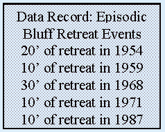
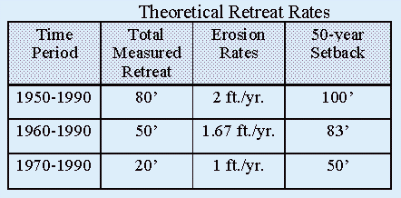
Table 3-2 shows some of the difficulties in attempting to quantify erosion rates and setback distances. As shown, if analysts had theoretical data showing shoreline change back to 1954, they would likely estimate an erosion rate of 2 feet per year and would anticipate that a 100 foot setback would be the minimum necessary setback for 50 years of stability. If the available theoretical data record only went back to 1970, the same site would be estimated to have an erosion rate of only 1 foot per year and a minimum necessary setback of 50 feet would be considered acceptable. If, in an effort to be conservative, the analysts were to add to the minimum setback a distance equal to the maximum single event of retreat, an analyst using the records from 1950 to 1990 would use the 30 foot retreat event from 1968, while an analyst using the records from 1970 to 1990 would only add a 10 foot retreat event. Thus, an acceptable setback for this theoretical site could range from 60 to 130 feet, depending on the extent of the data record used to develop the retreat properties. And since both setbacks are based on historic data, there is no certainty that either prediction will agree accurately with future events.
Table 3-2: Difficulties in Calculating Setbacks
The amount of pre-Coastal Act development along the shoreline
in Santa Cruz and Monterey Counties has substantially impacted
setback effectiveness in the ReCAP region, as has the high amount
of development concentrated in urban service areas. In urban areas,
most development is an "infill" situation where the
setback may be based not on the distance necessary to protect
the structure from threat during its life, but rather on the setback
of the adjacent structures, established as a "stringline"
from these structures. "Stringlines" are setbacks determined
by a line drawn between development on adjacent properties, rather
than by a standard setback distance. Ownership of a legal lot
of record presumes a right to develop the property regardless
of the coastal hazards that are present. Unless setback policies
change to address the issue of infill development directly, areas
of existing development will eventually be built-out based upon
a stringline approach that disregards hazards constraints and
sites development as near to the shoreline as possible, as is
evident in the majority of the surrounding parcels. Under this
scenario, infill projects allowed in high hazard areas based upon
historical land use decisions will eventually require the same
level of shoreline armoring as their neighbors.
For reconstruction after a natural disaster, Section 30610 of the Coastal Act allows reconstruction in the same footprint as the original structure without a CDP, precluding any analysis of potential alternatives -- regardless of the hazards involved. In fact, a conscientious applicant who attempts to set back the building envelope of a reconstruction parcel from the original footprint due to hazard constraints may be penalized by the imposition of CDP requirements. In each case, hard protective devices may be necessary in order to protect the structures prior to fulfillment of their economic lifetimes. The following examples illustrate the actual implementation of these setback policies:
Finally, even when a full 50-year setback is used, the value of
coastal land and the lack of alternative coastal locations makes
it unlikely that structures along the coast will be retired after
50 years or the completion of their theoretical economic life.
When structures are setback using a 50 year economic life, they
can be expected to "outlive" their setbacks and eventually
require armoring for long-term protection from erosion. ReCAP
did not collect information on building ages for development along
the coast; however, from field investigations and informal surveys
it seems that a number of coastal buildings are 40 to 60 years
old. If the generally accepted estimate of economic life reflected
actual structural life, most of these buildings would have been
removed. The 50 year economic life does not reflect the actual
lifetime of a structure or the length of time a coastal site will
be occupied. (Note: Statewide, 46% of the coastal jurisdictions
using setbacks based upon economic lifetimes used either 75 or
100 years.)[25]
If new development continues to be permitted in high hazard areas,
setbacks should function as they are intended to: allowing for
natural processes to continue without the adverse impacts that
would be associated with the introduction of hard protective devices.
By instituting a setback based upon a 75 or 100 year economic
lifetime and by using long-term average annual erosion rates,
a more realistic time span for retirement can be set for development.
If setbacks are based upon a practical economic lifetime for the
structure, shoreline armoring will be unnecessary with the removal
of these structures at the end of their economic lives. In tandem
with implementing this setback along the coastline, the regulatory
program would require procedural modifications to manage development
in these high hazard areas setting forth specific development
criteria and requirements.
In order to better address reconstruction policy, the consideration
of alternative strategies and/or sites should be encouraged. A
potential reconstruction project may need to analyze the viability
of the site due to the same hazard constraints to which new development
would be subjected. Options may run from an alternative building
envelope on the subject property all the way to acquisition of
the subject parcel and transfer of development credit programs.
One response to the problem may be to modify the policy of permit
exemptions to exempt reconstruction provided that the structure
is moved away from the hazardous constraints to the greatest degree
feasible, rather than sited in the same footprint or location.
For example, the policy language may say that reconstruction would
not require a CDP if the structure is located on a new footprint
landward of the previous building site, at the site most protective
of resources (e.g., most landward, setback for a 100 year lifetime,
not necessitating future shoreline protection, etc.). In this
way, landowners would continue to be allowed to reconstruct without
a CDP and hazard constraints would be better (although still not
fully) addressed.
The Coastal Hazards study by Griggs, Pepper and Jordan recommends
that "all development proposals, including reconstruction
or remodeling that increases the square footage of the structure
by more than 25 percent, must be evaluated on the basis of safety
from all coastal geologic hazards," and should be permitted
"only when safety from wave impacts and inundation throughout
the projected 100-year lifetime of the structure can be demonstrated
without reliance on a protective device."[26]
In the ReCAP pilot area, development has been located in high
hazard areas immediately adjacent to eroding shorelines. New development
in the region is likely to continue this practice and locate on
the remaining coastal lots. Once located in these areas of high
hazard, this development can be expected to be threatened by shoreline
erosion. The traditional response in the ReCAP region to such
a threat is to construct shoreline armoring to halt the erosion,
thus encroaching onto public beach areas in the process and shifting
much of the cost of risk reduction from the private development
to the public.
When development is allowed in areas of high coastal erosion,
it should come as no surprise that those developments will eventually
require protection if their shoreline locations are to be maintained.
This armoring of the coastline is typically put in place at substantial
public cost, both in terms of subsidies such as low-interest loans,
disaster relief funds, and joint public/private ventures as well
as public loss of beach area, beach access, and coastal aesthetics.[27]
With ocean processes and geologic instability contributing to
an actively eroding California coastline, coastal parcels today
are more at risk than ever before.[28] Since the current state
of coastal hazards planning does not systematically restrict development
in areas of high hazards, inappropriate development may continue
to be sited along the shoreline. Given the current coastal hazards
policy framework in California, costly shoreline armoring will
be required in order to maintain the development's perilous perch.
On the state regulatory level there appears to be a dichotomy
between Sections 30253 and 30235 of the Coastal Act regarding
the level of safety expected for siting new versus existing development.
Since many LCPs repeat these sections, the CCMP provides confusing
guidance on coastal hazards and shoreline armoring. While Section
30253(2) requires the stability of new development without future
reliance on protective devices, Section 30235 provides that a
recently built beach level or bluff top structure will be allowed
the exact protective devices that 30253 disallowed before the
structure was built. If the structure was truly built to not necessitate
future shoreline protective devices (as per 30253), little or
none of the development built since the Coastal Act should require
protective devices. Section 30235 allows seawalls to protect existing
structures where "existing" has been taken to mean the
time at which the application for armoring is made. While other
states have used cutoff dates coinciding with enabling legislation
for their definition of "existing" structures (for example,
existing as of January 1, 1977), or have legislation that prohibits
armoring or any construction seaward of a legislatively enacted
setback line, California has not taken these types of steps to
limit armoring.[29] For Sections 30235 and 30253 to function symbiotically,
there needs to be a cut-off date that treats pre-Coastal Act development
differently than post-Coastal Act development due to different
regulatory policies being in effect (i.e., pre-Coastal Act development
was not subject to Section 30253 and thus may require shoreline
protection while post-Coastal Act development should have been
constructed in such a way as to meet Section 30253 requirements
for stability and not require protective devices).
At a federal level, some programs contribute to the incremental
increase in reliance on shoreline armoring for coastal properties.
A federal agency that has a large impact on coastal hazard management
in California is the Federal Emergency Management Agency (FEMA),
which provides insurance for coastal properties and low-interest
loans for emergency armoring and rebuilding following a disaster.
FEMA assistance to private property owners who have built in areas
of high coastal hazards provides a direct public subsidy to private
development. Throughout the entire state, shoreline protection
and repair of damaged structures has averaged over $100 million
annually.[30] This is a significant expenditure of public and
private funds for shoreline development, with little, if any,
overall direction on the ultimate intent of these efforts.
While the construction of new armoring seems to have slowed since
enactment of the Coastal Act, additional armoring has occurred
in the ReCAP area with both regular and emergency permits approved
by the Commission. Much of the ReCAP area coastline, with the
exception of approximately 14 miles of shoreline close to the
Pajaro River and small isolated locations totaling another 6 miles,
has been identified as having either critical or non-critical
erosion.[31] Over 55 miles of coastline in the ReCAP area are
considered erosional. Over time, more and more "non-critical"
erosion will become "critical" as protective setbacks
become too small to continue to afford protection. In time, it
can be expected that most privately held developed coastal property,
and some publicly held coastal property, will be threatened by
erosion and property owners will apply for some form of shoreline
armoring. This type of future armoring will be increased by future
development of coastal lands or the conversion of coastal agricultural
lands to more development-intense land uses.
If current regulations for armoring continue, it can be expected
that eventually much of the coast will be armored, either with
vertical walls or rip-rap revetments. Future demands for armoring
can be expected from existing and future development, both future
development on existing lots of record and on future subdivided
lots. While some future demand for armoring may be prevented by
careful review of any new subdivisions to ensure adequate, long-term
setbacks for all coastal lots, such efforts will not be effective
for many existing lots of record or existing development. ReCAP
review identified that 12 miles of existing shoreline is now armored
and a rough review of land use patterns and shoreline characteristics
has identified over 27 miles of shoreline which may ultimately
be armored under existing policies.
Currently the ReCAP area encourages the use of rip-rap, which
would occupy vast areas of public beach. With a conservative estimate
of 20 feet of encroachment onto public beach by a rip-rap wall
and 4 feet of encroachment by a vertical wall, the current armoring
occupies approximately 25 acres of public beach; should the future
armoring estimates hold true, 27.5 miles of new revetment would
eliminate over 65 acres of shoreline from public use (comparable
in scale to losing all of Moss Landing or Natural Bridges State
Beach). In addition, as the shoreline continues to erode, the
beach in front of these walls will become smaller and ultimately
the walls will be in the surf zone with little or no usable beach.
Access stairs will drop into the surf and the only accessible
beach will be along small sections of coast without erosion or
at public parks.[32] Ultimately too, this loss of beach will limit
the ability of property owners to repair and maintain their seawalls.
Land use planning with an emphasis on coastal hazards avoidance
would identify those areas of rapid coastal erosion and high ocean
impacts where it is not appropriate to site public or private
development. These high hazard areas will eventually require some
type of hazard response at considerable public expense. It is
clear that coastal land-use planners and regulators need to develop
new ways for looking at the issues of coastal hazards.
ENDNOTES
![]() Return to previous chapter,
Chapter 2: Regional Overview
Return to previous chapter,
Chapter 2: Regional Overview
![]() Go to next chapter, Chapter 4: Public Access
Go to next chapter, Chapter 4: Public Access
![]() Return to ReCap Pilot
Project...Monterey Bay Region Table of Contents
Return to ReCap Pilot
Project...Monterey Bay Region Table of Contents
![]() Return to California Coastal Commission Home Page
Return to California Coastal Commission Home Page