
Evaluating the cumulative impacts of development on coastal resources requires factoring in how the coastal zone is impacted by (and impacts) the surrounding area. While the ReCAP area is bounded by the coastal zone in Santa Cruz and Monterey Counties, it is important to place it within the context of the Monterey Bay region and to consider the particular characteristics of the overall resource area of the two counties combined. In order to generate this regional perspective, this chapter presents a brief overview of population and growth trends in Monterey and Santa Cruz Counties. Clearly, these population and growth trends are prime indicators of the overall increased pressure on coastal resources -- it is this cumulative pressure over time that must be addressed within the California Coastal Management Program (CCMP).
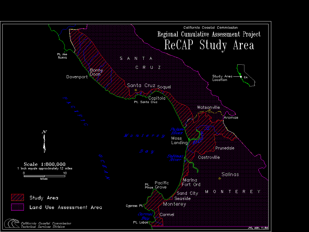
Monterey and Santa Cruz Counties are situated south of the San Francisco Bay area along California's central coast. The diverse geography of the region encompasses mountains, forests, rolling hills, agricultural lands, sand dunes and beaches. The range of natural resources in tandem with a mild climate, world-renowned scenic vistas, and a multifaceted cultural identity combine to make the Monterey Bay area a very desirable region in which to live and visit. The influx of people attracted by the area's special character has also brought with it extensive development and regional growth. Within the two-county region, the ReCAP area is defined by the coastal zone extending from the Santa Cruz/San Mateo county line through Point Lobos State Park in Monterey County (see Figure 2-1). Within these borders, the ReCAP coastline stretches 83 miles and encompasses the largely undeveloped and agricultural north coast of Santa Cruz County, the beaches in and around the cities of Santa Cruz and Capitola, a nearly unbroken 25-mile stretch of dunes, and the rocky coastline of the Monterey Peninsula and Carmel.
Figure 2-1: ReCAP Study Area and Land Use Assessment Area
Partially isolated by the coastal ranges of the Santa Cruz and Santa Lucia Mountains, the Monterey Bay coastline is home to rare forests of redwoods, pines, and cypress, largely undeveloped dune systems, extensive slough and wetland complexes, large tracts of rare and endangered species habitat, as well as Monterey Bay itself. Providing opportunities for surfers, fishermen, divers, marine researchers, kayakers, and boaters, among others, Monterey Bay has long been a focal point for area residents and visitors alike. The Bay supports an extensive population of marine species and is site to the largest submarine canyon in North America. The unique grandeur of the region and its national significance was formally recognized in 1992 when the Monterey Bay became part of the largest federally protected marine sanctuary in the nation (Monterey Bay National Marine Sanctuary).
In analyzing the population changes impacting the project area, it would be useful to analyze both the population trends within the coastal zone and those of the region as a whole. Unfortunately, United States Census data is not kept in a manner which recognizes the coastal zone boundary. Because of this, and because population growth in a region will impact coastal resources regardless of which side of the coastal zone boundary the growth occurs, ReCAP chose to evaluate population growth in the overall two-county region. In fact, county-level population data is probably a more realistic gauge for measuring overall increased pressure on (and demand for) coastal resources in the ReCAP project area since these resources are used by more than just the coastal zone population.
Monterey and Santa Cruz Counties have both experienced significant growth in population since the early 1900s.[1] As shown in Figure 2-2, nearly seven times as many persons lived in Monterey and Santa Cruz Counties in 1995 as did in 1930. Clearly, this transition from small coastal counties to growing population centers has had an overall effect on resource conditions in the region. More people leads to the need for more housing, more infrastructure, and more businesses, the development of which may result in more resource impacts. As urbanization increases, the health of natural resource systems may cumulatively decline.
Figure 2-2: Population of the ReCAP Counties, 1930-2010
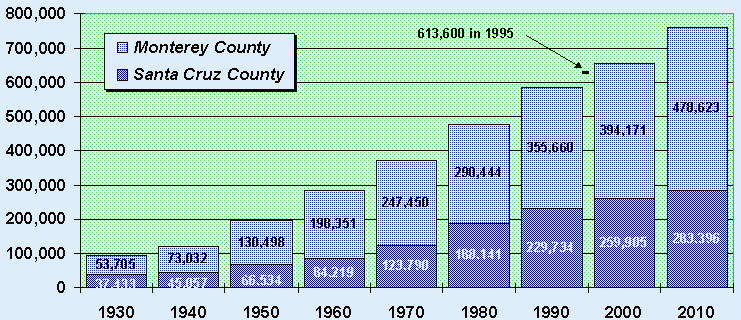
Source: U.S. Census of Population and Housing (1930-1990); California Department of Finance January Estimates (1995); AMBAG population projections (2000-2010)
These historical levels of population growth have been maintained since initiation of coastal management efforts in the early seventies.[2] Monterey and Santa Cruz Counties combined have increased by nearly a quarter of a million persons in the past twenty-five years -- an average of nearly 10,000 persons per year.[3] While Santa Cruz County is much smaller than Monterey County, both in terms of land area and overall population, both counties have grown in population by roughly the same amount since 1970.[4] This growth represents a 65% increase in persons for the two-county region; roughly equivalent to the 62% growth in California during the same time period. This regional growth is impressive not only because there are natural barriers to growth (such as coastal mountain ranges), but also because there have been various growth management measures put in place over the years. These restraints have ranged from legislative efforts such as Santa Cruz County's Measure J in 1978 which set annual growth limits, to low-growth community opposition groups, to efforts to limit the expansion of urban services and infrastructure. The overall population in Santa Cruz and Monterey Counties declined for the first time in 1994 due to the closure of Fort Ord. However, with Fort Ord converted to the new California State University at Monterey Bay, this decline is likely to be a temporary phenomenon. In fact, according to preliminary estimates, a positive population growth rate has been reestablished for the two county area in 1995.[5]
Projections of future population growth show that the Monterey Bay region is expected to maintain the long term growth patterns evident from the historical census figures in Figure 2-2. The two counties should continue to maintain the 10,000 new persons a year pace with an increase of nearly 150,000 persons by the year 2010.[6] Should these population projections hold true, Santa Cruz and Monterey Counties in 2010 would have more than double the number of people as were living there when the Coastal Act was passed. Such ongoing population growth will increase the regional need for housing, jobs, roads, urban services and infrastructure, water, parks and recreational areas, and overall community services. For coastal counties such as Monterey and Santa Cruz where the vast majority of residents live within a half-hour of the coastal zone, coastal zone resources are seen as a critical element in helping to meet these needs. Furthermore, with coastal zone resources themselves attracting visitors into the region, an even greater demand for services and resource pressure is likely to continue along the coast; as with any finite resource, currently impacted coastal resources will likely be even more at risk in the future.
Ongoing population growth in the ReCAP area has been mirrored by an increase in urbanization for the Monterey Bay area. From historical surveys, it is clear that vegetated areas and areas in agricultural production have been steadily declining in the past twenty years at the hands of an ever-expanding urban and suburban landscape. Urban and suburban land use, though still a relatively small proportion of the total land use area, has increased 43% in the greater Monterey Bay area since 1976 (see Figure 2-3).[7] This increase has been even more pronounced in the southern portion of the greater Monterey Bay area with over three-fourths of the urban and suburban acreage increase occurring in the Monterey County segment.[8] In addition, though the offsetting decline in agricultural lands has been shared equally by the two segments, the decline in vegetated area was confined almost exclusively to the Monterey County segment.[9] These changes would appear to point to a more extensive urban and suburban expansion in the southern portion of the Monterey Bay region. This expansion brings with it increased impervious surfacing, increased human presence, and increased encroachment into natural resource buffer areas (e.g., wetland and dune complexes).
Figure 2-3: Land Use Changes in the ReCAP Region, 1976-1989
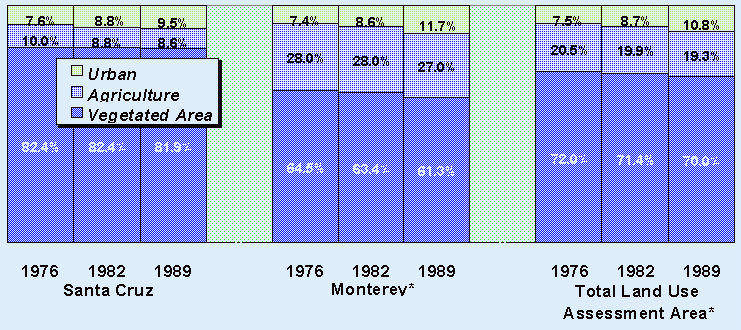
Source: DWR Quad County Summaries (* See Figure 2-1)
Placing this overall urban expansion within the perspective of the CCMP and the project region, ReCAP aerial photo analysis of development patterns in the coastal zone since the 1970s confirms these overall urbanizing trends.[10] Within Santa Cruz County's coastal zone, most new development has occurred within or adjacent to the urban services line (i.e., the boundary point for such infrastructure as gas, water, and sewage hook-ups), especially in the unincorporated areas of Live Oak (the area between the cities of Santa Cruz and Capitola) and the Aptos shoreline. While the Live Oak infilling occurred within an area already considerably "urban", the expansion in 1984 of urban services into the Aptos area led to the conversion of large belts of vegetated area into the urban landform (e.g., planned development in the Seascape area). The general development pattern in Santa Cruz County's coastal zone has been a concentrated urban band extending from the City of Santa Cruz southeast to La Selva Beach; very little new development occurred in other areas of the County's coastal zone. This pattern appears to reflect a strong adherence to Santa Cruz County's LCP goal of concentrating development in already urbanized areas and protecting agricultural lands. While concentrating new development in urban areas creates cumulative impacts on such coastal resources as urban wetlands that find themselves slowly hemmed in by increased development, infrastructure, and population, it minimizes the impacts to resources in less developed areas.
In Monterey County, by contrast, ReCAP aerial photo analysis confirmed that while there was significant growth in such areas as Marina and Del Monte Forest, a considerable portion of new development within the coastal zone occurred in semi-rural areas of North Monterey County -- especially in the areas north and east of Elkhorn Slough. This type of semi-urban expansion into rural areas, largely outside the reach of urban services such as water and sewer service, is clearly different from the expansion taking place in Santa Cruz County that is primarily within areas that could be considered at least partially "urban". Although per acre densities are low in North Monterey County, the amount of new development is sufficient to warrant concern about short- and long-term cumulative affects on nearby Elkhorn Slough. Sediments loosened during construction can end up as deposits in the slough, and the increase in impervious surfaces such as roads and rooftops will cause long-term cumulative changes in the hydrology of the watershed. In addition, with most of this new development dependent on septic systems for sewage disposal, there are water quality implications for nearby wetland systems. The expansion of urban and suburban development into areas with high resource value exemplifies the type of situation in which cumulative impacts can easily be overlooked because each individual project appears to have only minimal impacts.
The land use surveys and aerial photo analysis are further supplemented by CCMP permitting information within the ReCAP study region for the past decade. The data show that while new development pressures were widespread in the region, nearly 60% of the permit activity occurred in unincorporated Santa Cruz County and the northern portion of Monterey County (Figure 2-4).[11] With nearly 30% of all permitting activity in the region, the North Monterey County LCP segment appears to have been the CCMP hotspot for development in the ReCAP study area.
Figure 2-4: Coastal Commission and local government permitting in the ReCAP Area 1983-1993
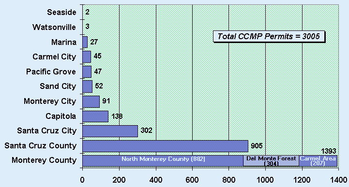
Source: ReCAP Database
ReCAP's analysis of future development trends in the pilot region portends continuation of these existing land use practices: primarily infill within Santa Cruz County's coastal zone and further urban expansion into the semi-rural areas of Monterey County.[12] For Santa Cruz County, a considerable amount of vacant lands zoned for urban uses (residential, commercial, industrial, or government/institutional) still exist within primarily urban areas. With few urban uses currently allowed for vacant parcels outside of the urban services line, growth pressures should continue to be felt within the urban band extending from the City of Santa Cruz to La Selva Beach. This scenario is supported by the County's own analysis showing that primary growth areas should continue to be in the Live Oak and Aptos planning areas.[13]
However, with a large amount of additional growth already approved in the Seascape area along the southern boundary of the urban services line, there is also the potential for development pressures to extend southward. In fact, ongoing pressures to develop outside the rural/urban boundary line are already evident through a number of development proposals, particularly in southern Santa Cruz County. While funneling development within the more 'urban" areas (in Live Oak and Aptos) is more protective of rural and agricultural lands, development pressures outside the urban services line (southern Santa Cruz County) show that these less urban areas are also at risk. Overall, this planned infilling leads to the need for increased management of cumulative impacts. In urban areas, shrinking resource buffer areas, increased parking demand, and overall increased shoreline use will lead to an intensification of impacts to shoreline resources and public access. These potential impacts will require comprehensive planning efforts focusing on defined 'systems' (e.g. public access plans, wetland and watershed ecosystem planning, coastal hazard area management plans, etc.).
Within Monterey County's coastal zone, while limited infilling of urban areas is expected, ReCAP's analysis of vacant lands in the region points to a number of areas with the potential for conflicts between development and natural resources. For example, much of the vacant land in the Elkhorn Slough area is zoned for residential use, albeit at low densities. With good access to the job market in the Santa Clara Valley and San Jose via Highway 101, demand for residential development in this area is likely to continue. The Del Monte Forest LCP segment also has large vacant areas planned for residential and golf course development. The redevelopment of Fort Ord has the potential for creating resource conflicts on large remnants of native habitats as well as on beaches and bluff areas that had heretofore been closed to public access. The dune habitats of the county are also at risk, with the largest areas of undeveloped shoreline in the ReCAP region zoned for urban uses located in the shoreline dunes of the Cities of Marina and Sand City. Given the fragile nature of these resource systems, a high priority in the southern portion of the ReCAP region should be placed on developing policies that manage and/or avoid cumulative impacts within sensitive areas (e.g., refining performance criteria for particular resource systems, developing management plans for particular resource areas, directing development away from sensitive areas, etc.).
The population figures for the Monterey Bay region demonstrate that there has been substantial historical growth in Santa Cruz and Monterey Counties with projections indicating that this growth will continue in the future. The two counties' combined population increased nearly seven-fold since the early 1900s, with an increase of nearly one-quarter of a million persons since 1970 alone. Future population projections estimate that this rate of increase of nearly 10,000 persons per year will be maintained, with nearly 150,000 new persons being added to the two county region by the year 2010. This ongoing population growth highlights the regional need for increased housing, jobs, roads, urban services and infrastructure, water, parks and recreational areas, and other community services. With coastal zone resources seen as a critical element in helping to meet these regional needs, individual LCPs must be able to address these regional, 'greater than local' needs.
In terms of overall development trends, an increasing populace has contributed to a 43% increase in the urban landform for the greater Monterey Bay area over the past twenty years. Within the coastal zone of Santa Cruz County, this development appears to have been primarily concentrated in existing urbanized areas within the urban services line. For Monterey County's coastal zone, a considerable amount of development appears to be due to urban expansion into semi-rural areas in and around Elkhorn Slough; CCMP permitting history shows that nearly 30% of all permits issued in the past decade in the ReCAP area were issued in the North Monterey County LCP segment. In terms of future trends, Santa Cruz County's coastal zone can expect development to be funneled to areas within the urban services line in the Live Oak and Aptos planning areas. For the coastal zone in Monterey County, areas of potential growth appear to be in and around areas of coastal resources such as wetlands, dunes, and forests. While there are different policy implications for these differing development trends within the two counties, incorporating management of both resource 'systems' and cumulative impacts into LCP policy is crucial for ongoing resource protection in the Monterey Bay area.
ENDNOTES
![]() Return to previous chapter,
Chapter 1: Introduction
Return to previous chapter,
Chapter 1: Introduction
![]() Go to next chapter, Chapter
3: Coastal Hazards
Go to next chapter, Chapter
3: Coastal Hazards
![]() Return to ReCap Pilot
Project...Monterey Bay Region Table of Contents
Return to ReCap Pilot
Project...Monterey Bay Region Table of Contents
![]() Return to California Coastal Commission Home Page
Return to California Coastal Commission Home Page