![]()
The California Coastal Commission recently held a workshop on fire/flood hazards present in the Malibu/Santa Monica Mountains region. This workshop focused on fire and building code changes that have been implemented by the County of Los Angeles and the City of Malibu following the fires of 1993. Issues addressed during this workshop, were related to emergency vehicle access, building code changes, water availability during a major crisis, and disclosure of hazards from wildfire to private property owners.
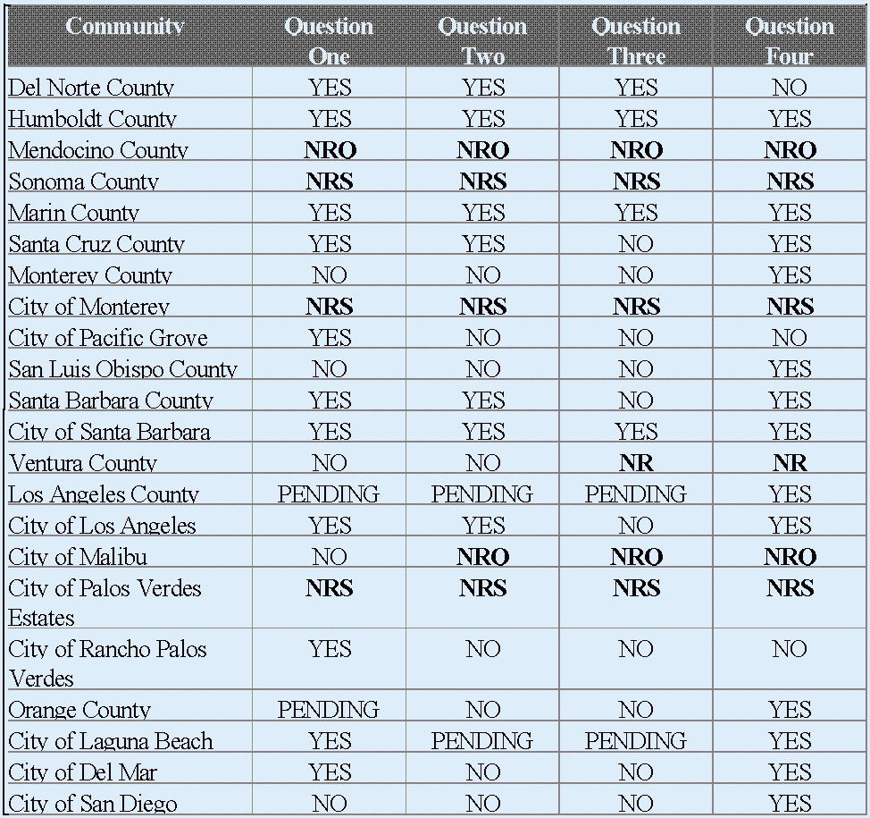
This report is in response to a request by the Commission to conduct a survey of communities statewide within the coastal zone where there is a reasonable possibility of wildfires originating in or being carried by areas of natural vegetation and thus creating a risk to life and property. This survey was developed to ask what these communities have done to strengthen their building and fire codes following the numerous wildland fires over the last decade.The following communities were surveyed:
Del Norte County
Humboldt County
Mendocino County
Sonoma County
Marin County
Santa Cruz County
Monterey County
City of Monterey
City of Pacific Grove
San Luis Obispo County
Santa Barbara County
City of Santa Barbara
Ventura County
Los Angeles County
City of Los Angeles
City of Malibu
City of Palos Verdes Estates
City of Rancho Palos Verdes
City of Laguna Beach
Orange County
City of Del Mar
City of San Diego
On November 3, 1993, the second of two arson suspected fires burned out of control throughout substantial portions of the Santa Monica Mountains. At this same 21 wildland fires were burning throughout Southern California, from Santa Barbara to the Mexico border. Three of these fires, the Green Meadows, Old Topanga, and Laguna Hills Firestorm, were located within the coastal zone and consumed over 739 single family residences (SFR). The Old Topanga Firestorm erupted near the southern limits of the City of Calabassas and consumed approximately 18,000 acres of watershed, took the lives of 3 people, and destroyed or damaged over 408 SFR. Over 208 SFR were lost in the City of Malibu alone. The cost of this fire was high in terms of property damage, loss of infrastructure, and in regards to its impact on environmental sensitive habitat and watershed coverage.
In the Wildfire Safety Panel report to the Los Angeles County Board of Supervisors the County Fire Department provides a history of wildland fires in the Los Angeles basin. This history can be applied to many other communities of California, and it reads as follows:
Less than one percent of all wildfires escape early control. It is that fraction of a percent that is responsible for the most damaging fires. In Los Angeles County there have been more than 20 catastrophic wildfires since the beginning of organized fire protection. The Los Angeles County Fire Department experienced their first urban interface fire long before the term was ever invented. On a windblown evening in December 1927, a fire in the La Crescenta Valley roared up and over the Verdugo Mountain range destroyed more than 100 homes. That fire was the first of many that would mold and shape our current fire restrictions, codes, and fire suppression tactics.
It was not unexpected when the Kinneloa Fire in the Altadena area and the Old Topanga Fire of Malibu exploded into Firestorm '93. These areas had burned before as had nearly every square mile of the brush-covered areas of the county since 1919. The Kinneloa Fire destroyed more homes (121) along the foothills of the San Gabriel Mountains than had previously been destroyed. Previously, the worst fire occurred at the mouth of the San Gabriel Canyon in November 1980 destroying 55 homes. In the past 60 years, a dozen fires have destroyed 332 homes along the front country of the San Gabriel Mountain range. As bad as that is, it pales in comparison to the fire history of the Santa Monica Mountains.
It is in the Santa Monica Mountains range where fires have crisscrossed the terrain so often that some residents not only have lost one home, but some sadly have lost three after rebuilding on the same site. The Santa Monica Mountains are a true design for disaster. In the fall and early winter months, as if on a regular schedule, strong Santa Ana winds howl through the canyons and out to sea and the relative humidity plummets to single digits. After the long hot summer has taken its toll on chaparral, often stressed by repeated droughts, the winds set the scene for disaster. Once a fire gains a foot-hold, with Santa Ana winds blowing it is virtually impossible to contain until the wind abates or it runs into the sea. The fires historically follow well-defined wildfire corridors. When large and damaging fires occur you'll find the wind and fire corridors perfectly aligned.
When fire roared down Old Topanga Canyon in November of 1993, it destroyed more homes than any previous fire in the history of the Los Angeles County Fire Department. The Malibu Fire in October 1978 was the worst previous fire laying waste to thousands of acres and 230 homes. The Old Topanga Fire destroyed 369 homes and resulted in the deaths of three civilians. The fire transversed a total of seven previous burns through brush that was as young as eight and as old as 70 years. It had been eight years since the last major fire.
Since 1927, a total of 24 wildland fires have caused the loss of 1,502 homes, 830 other structures, 271,047 acres and five fatalities. Previous fires include the 1985 Malibu Fire, 1982 Dayton Fire (85 homes destroyed), and the 1970 Malibu Canyon Fire (103 homes destroyed). The 1993 Old Topanga Fire burned much of the same area covered in the 1970 burn. The last time Topanga Canyon had seen a damaging fire was December 1958 when 74 homes were reduced to rubble. Between 1938 and 1943, three fires destroyed more than 600 structures in the Topanga Canyon area.
Following the fires of 1993, several sources identified various reasons for the extent and intensity of the conflagration. Although weather played a major role, much of the blame could be placed on human factors ranging from the location of homes in dense chaparral habitat, poor maintenance of ornamental landscapes, inadequate water supply and access for emergency vehicles, and the existence of structures which predate current building and fire codes. The County of Los Angeles is currently reviewing the factors which lead to the Old Topanga and Kinneloa Firestorms and developed a task force to recommend changes to fire and building codes to mitigate the magnitude of future fires. In developing this survey, Coastal Commission staff reviewed documents which followed the 1993 fires as well as the Oakland and Berkley Hills Fire.
The hazard of firestorms is not unique to the Malibu/Santa Monica Mountains coastal zone, nor are the various contributing factors which lead to the extent of the 1993 Old Topanga Firestorm. As similar fires have occurred in coastal communities over the last decade, such as the Laguna Beach and Oakland and Berkley Hills fires, Commission staff asked the surveyed participants to responded to the following questions:
1. Have there been any recent changes in your building or fire codes to make structures more resistant to fire damage, and what are they?
2. Have there been any recent changes in road standards intended to accommodate emergency vehicles?
3. Have there been any new requirements regarding the availability of water for fire control purposes.
4. Is there any system in place in your jurisdiction for alerting citizens who build structures, or acquire property, in fire prone areas of the presence of hazards associated with wildland fire?
The following is a summary of participants responses to the survey. Some of the responses where brief, while others where quite lengthy. All of these responses are on record in the Ventura Office of the California Coastal Commission, and can be made available upon request. Table A provides a quick reference to the response of our survey; however, these responses do not take into fact existing fire codes and measures that the communities may already have in place and have found to be effective, or those that are currently proposed but not adopted at this time. Please refer to the following summary of each community for a more detailed response to what each community has done in regards to protection from wildfire.
Table A: Quick Reference of Survey Responses
NRQ: This indicates that the community surveyed did not respond to this question.
NRS: This indicates that the community surveyed did not respond to the survey.
PENDING: This indicates that proposed changes are under review and may or may not be approved.
The County of Del Norte worked with the California Department of Forestry (CDF) in 1991, under the Fire Safe program to update the county's standards. This included 1) amending road standards to meet CDF guidelines, particularly in hillside areas, which included adequate slope, surface, turnout and turnaround for emergency vehicles, 2) establishing hillside density, spacing and setback requirements, and 3) codifying policies regarding the provision of water for safety emergencies. However, there is no specific program to notify persons of wildfire in the county.
Recent changes in the State Building Code (SBC) have mandated the use of more fire resistant materials in roofing and siding, and these changes have been implemented by Humboldt County. However, The County of Humboldt's fire safety regulations refer primarily to State Responsibility Areas (SRA). Areas of potential wild land fire hazard coincide closely with areas designated as SRA, and therefore these areas are under protection of the CDF.
Although the Mendocino did not respond directly to the questions of the survey, the County submitted a package of CDF materials indicating that the county receives protection from CDF in the form of SRA. Furthermore, as mandated SBC changes require that local government set these standards as a minimal requirement, the recent changes that have occurred in Humboldt County apply here as well.
There was no response to this survey by Sonoma County.
Marin County requires a minimum of Class "A" fire rating for all new roofing and reroofing on all structures, and that automatic sprinklers be installed in all new structures, including dwellings and substantial remodels. The County Board of Supervisors recently inacted "Title 24", a local ordinance that governs the development of road and drainage systems. Section 24.02.030 of this title incorporates SRA development standards into the jurisdiction of the Department of Public Works. As much of Marin County is also located within areas designated as SRA, recent state wide changes to the SBC apply here. Furthermore, the County Fire Marshal assists the Department of Public Works in regulating roads and signage, and enforces State Firesafe regulations regarding water storage and vegetation management.
Marin County has two methods for informing the public of potential wildland fire hazard. The Community Development Agency and Department of Public Works have a common public information counter where the public may purchase small and large scale SRA maps and general information about wildfire hazards. The Fire Marshal further reviews all development in SRAs within the coastal zone for conformance to all County provisions incorporating State Firesafe regulations. For instance, discretionary approvals generally granted for projects within the Coastal Zone SRA require submittal of a vegetation management plan to the Fire Marshal before issuance of a Building Permit. The Fire Marshal then inspects the plan for compliance with the plan before occupancy of the structure is permitted.
Although Santa Cruz County has not adopted recent changes in their build or fires codes, since 1989 all new single family dwellings have been required to have sprinklers, and fire retarding roofs have been required since 1988. The 1994 General Plan and Local Coastal Program, effective December 19, 1994, has increased the required road width from 16' to 18', and a reduction in width can only be granted pending approval of the Fire Department based on the existence of "extenuating environmental circumstances". Standards regarding gates and radii for all access roads are also included. The County adopted constraint maps in 1980. These maps indicate areas prone to fire hazard, and these areas have been mapped in the county's Electronic Mapping Information System.
Monterey County has not recently made changes to their fire or building codes since 1990-1991, however, these changes are currently being implemented. Furthermore, the coastal zone of Monterey County is governed by Land Use Plans along with Coastal Implementation Plans drafted in accordance with the California Coastal Act. The development standards of the Coastal Implementation Plan state that properties located in areas of "High" or "Very High" fire hazards, as indicated on the current California Department of Forestry Fire Maps and as projected on the Coastal Implementation Resource Maps, require deed restrictions be recorded to ensure compliance with the restrictions of the Coastal Implementation Plan, County Fire Warden and local fire division.
There was no response to this survey by the City of Monterey
The City of Pacific Grove has in place a sprinkler ordinance which applies to all new structures built, regardless of square footage or occupancy classification (residential or commercial). There is also a remodel / addition / change of occupancy or use clause that applies to commercial structures. Although no other formal changes have taken place, statewide changes apply in this community as they do elsewhere.
Since 1980 the county construction ordinance has required that new and replacement roofing materials have at least a Class "C" fire rating. On site water storage, fire department access, and in some cases sprinklers and non-combustible exterior wall coverings, are required for residences in high fire severity areas. Several years ago the County also adopted new standards to address state codes regarding road width, slopes, and other state standards. The CDF uses the National Fire Protection Association guidelines for standard rural water systems in rural areas outside of established county water districts, where as standards set by the Uniform Building Code are used within established water districts. The CDF has also established a program where each home built in high and very high severity zones are conditioned to meet access, water storage and vegetation clearance standards.
Prior to the 1990 Paint Fire, Santa Barbara County had a high fire hazard area building material ordinance which covered roofing materials, eaves overhangs, siding materials, etc. Following the fire, adjustments where made to the existing codes regarding dual glazing of windows, and the exclusion of wood roofing entirely. In 1987 the County Fire Department adopted a fire sprinkler ordinance that requires all structures "outside of the Urban Limit Line" install an approved automatic sprinkler system. Although most roads standards meet or exceed state wide standards, those standards that did not have recently been updated. The County has further required the storage of water for fire protection for at least twenty years.
The County of Santa Barbara has also identified a "High Fire Hazard Area" for the last twenty years. These areas are indicated on published maps which show incorporated and unincorporated areas. This map is posted in all building departments within the County. Furthermore, citizens who own property and wish to build or make changes are notified if they are in these fire prone districts, and are required to mitigate potential problems which may result in the intensification of use of their property. A wildland fire prevention program is also in place which includes an annual hazard reduction (weed abatement) program along with ongoing public education efforts. This is an addition to the State requirement that new buyers be notified of such a high fire hazard area as a condition of sale.
The City of Santa Barbara may have the most progressive approach to wildfire safety in the entire state. Following the Sycamore Canyon fire of 1976, when 250 homes were lost, a Fire Department Master Plan was developed by a Blue Ribbon Committee consisting of government leaders, homeowner's associations, business groups and fire officials. The results of this committee are published in a Fire Master Plan, dated May 1, 1979. This Master Plan, and the City's "High Fire Hazard Building Code", Ordinance No. 4639, adopted July 24, 1990, as well as the City of Santa Barbara Uniform Fire Code, Ordinance No. 4771, adopted June 2, 1992, provide guidance for the protection of structures, road standards, water availability, as well as roofing and building standards in regards to wildfire protection.
The City Fire Department also provides an educational service to the community via a Firescapes Demonstration Garden. This garden is a model for fire protection of structures located in high fire areas. The garden uses a four zone landscape design with native and drought tolerant plantings which extent from the wildland interface zone, or area of native chaparral, to the foundation of the structure/dwelling. Zone One, lying closes to the structure, uses properly thinned/pruned and fire resistant vegetation. Zone Two use highly fire retardant succulents and groundcovers which creates a greenbelt zone of maximum fire protection. The plants of this zone also tolerate drought and poor soils, providing additional advantages. Zone Three consists of native and introduced plant species of a low growing and slow burning nature. These low profile plants reduce the flow, or nature, of fire. Zone Four, laying furthest from the structure, contains native vegetation, chaparral, thinned to reduce foliage mass, or fuel load. These species, when properly thinned, will reduce the spread of fire and provide continued erosion control and site stability. The garden provides a living example of a fire resistant landscape, and shows the beauty of the plants used to achieve this added protection.
The Fire Department further provides handouts illustrating how to develop a similar landscape for residents, and lists plant species which are appropriate in each zone. The City also has sections of the City mapped out that may experience a high risk of wildland fire. These maps are available at the demonstration garden and through the Fire Department and other City offices.
Although no changes have occurred to date, the County Public Works Agency has indicated their concern regarding the impacts of a high intensity fire on road culverts and drainage pipes. They have also stated that should these systems fail as a result of high heat, access roads could in turn be undermined and thus prevent fire fighting equipment from entering or exiting a fire zone during wildfire.
Following the fires of 1993, the Los Angeles County Board of Supervisors created the Wildfire Safety Panel to recommend changes to the County Uniform Building Code, as well as changes to related fire codes. The panel released its recommendations on June 17, 1994, however, these changes have not been adopted as yet, and further task forces have been designated to address some of the proposed changes. Staff from the California Coastal Commission are currently seated on one of these task force, as are staff from other state and federal agencies. Some of the recommended changes pending regard water supply, building and fire codes, vegetation, and brush clearance code enforcement.
The City of Los Angeles adopted what is commonly referred to as the "Hillside Ordinance" on August 4, 1992. This ordinance regulates construction and enlargement of single family dwellings in hillside areas of the city, including fire-prone areas. The ordinance requires an entire dwelling or accessory building to be sprinklered for; (1) new construction of a dwelling or detached accessory building (including garage), (2) an addition of 50% or more to an existing building or accessory building, and (3) for major remodel fronting on a substandard hillside street, or located more than 2 miles from a LAFD Truck Company or 1.5 miles from an LAFD Engine Company.
For new construction of an addition to a single family dwelling, the ordinance requires that substandard hillside limited streets must have at least one-half of the width of the street dedicated for the full frontage of the lot or as determined by the City Engineer. If the street is improved to a width of less than 20 feet, then permits must be approved by a Zoning Engineer. Furthermore, the City presently has mapped areas of "Mountain Fire District" and "Fire Buffer Zone".
The City of Malibu adopted the County of Los Angeles Uniform Building Code in 1991, and the city receives its fire protection from the County of Los Angeles Fire Department. Due to these two facts, the pending recommended changes addressed by the Los Angeles County Wildfire Safety Panel will apply here as well. Aside from this, the City of Malibu has made no changes following the Old Topanga Firestorm of 1993.
There was no response to this survey by the City of Palos Verdes Estates
The City of Rancho Palos Verdes amended Chapter 32 of the Uniform Building Code in August of 1992 to require that a Class "A" roof covering assembly be incorporated into new development. This has been the only recent change.
Following the firestorms of 1993, the County of Orange Fire Department established the Wildland/Urban Interface Task Force to review issues regarding fire management between urban and open space lands. Four subcommittees were formed to address specific issues regarding Building and Fire Codes, Fuel Modification, Open Space and Existing Conditions. The Building and Fire Code Committee developed a recommended code package for use in the wildland/urban interface. These proposed amendments are currently under review. Recommendations regarding noncombustible roofing, boxed-in eaves, noncombustible siding materials, dual pane windows, vents on structures placed away from the exposed side of the structure, and the installation of automatic fire sprinkler systems are among the items under review. Fuel modification zones were also recognized as an important factor in fire protection, and standards for such zones are incorporated into the code proposals.
New roads within the County of Orange meet or exceed minimum standards for fire safety, and water availability for fire protection begins at the predevelopment level, and water districts are responsible for providing the quantities needed for such protection. Developers are also required to place notes on tract maps which indicate areas of high fire hazard. Individual proposed structures for construction on existing lots are required to be reviewed by the fire authority prior to permits being issued. This review is to ensure that the structure will have a Class "B" or better roof material, that sufficient water for fire protection purposes is available and that vegetation around the structure has been properly cleared and or thinned.
The City of Laguna Beach established a high fire hazard area about fifteen years ago. The area encompassed much of the City inland of Coast Highway. Building code requirements in the high fire hazard area that exceeded requirements in the nonhazardous area include: fire retardent roofing (Class "B" minimum with no wood shingles or shakes allowed regardless of degree of fire retardancy), one-hour protection of roof eaves, minimum cross section area for exposed wood members used for patio covers and decks, Class "C" (pressure treated) minimum for wood shingle or shake siding and spark arrestors on all chimneys.
Following the October 1993 fire, the high hazard fire area was expanded to include the entire City and two minor changes were made to the fire code resistive requirements for building construction: no openings are now allowed in required one-hour roof eave protection and vent openings in the building are limited to a maximum of 144 square inches in area (each vent) and must be covered with corrosion resistant screening. In addition to these requirements, the City provides the following list of recommendations at the Community Development counter:
A. Use of non combustible siding or use of fire-rated gypsum wallboard under combustible siding.
B. Limiting the window area in walls that face the wildland interface and use of dual glazing in all windows.
C. Providing stucco on the underside and supports of all decks or provide a fire rated wall at deck edge that extends from deck surface to grade.
D. Use of a fire retardant surface covering on decks.
The City is in the process of updating its Safety Element of the General Plan. This evaluation may result in the adoption of new access standards for emergency vehicles. In addition, the City is studying the feasibility of augmenting emergency access in several residential neighborhoods. Although the City has not made changes to its standards regarding water availability, the Laguna Beach Water District is upgrading the City's water supply system by "cross looping" water mains and adding new fire hydrants, as well as relocating some of the existing hydrants. A new water reservoir is also set for construction in the near future.
Finally, the City has various programs designed to alert citizens of urban/wildland interface areas. The Laguna Wildland Hazard Identification Mitigation Systems is a program that provides public education to inform homeowners of the hazards and problems of the wildland fire area by annually inspecting over 1,400 homes on the interface. The City also has an annual weed abatement and fuel modification program. In addition, the City hosts an annual open house in May at the various fire stations in the City to provide public information to residents on the wildland fire hazards. Pamphlets and brochures can also be obtained regarding this matter at the fire stations in the City.
The City of Del Mar made recent changes to the Building Code so that all new roof use Class "A" materials. Additionally, if 25% or more of a roof's surface in replaced within a 12 month period, the entire roof must be of Class "A" materials as define by the Building Code. The City also advises the citizens through Fire Prevention Programs which include door to door meetings that explain the risks of wildland fires and how citizens can help reduce their landscape fuel load.
The City of San Diego Fire Department utilizes two documents regulating access requirements for emergency vehicles and the clearing of brush around structures. These documents were released in 1991, and 1989 respectively. A third publication "Protection of Life and Property from Wildfire" (1991 Edition) is also used as a reference source. Road standards to accommodate emergency vehicles are governed by the Fire Prevention Bureau Policy A-93-1, "Fire Access Roadways", and requires that all roads be a minimum of 20 feet wide, support 95,000 pounds and be an all weather driving surface. The Street Design Manual is currently being revised and will incorporate minimum Fire Department Standards.
The Fire Department has specific water requirements for the more rural parts of the City, based on square footage of fire area and building construction type. Where fire mains and hydrants do not exist or would be impractical to install, a water storage tank for fire fighting purposes is required. This tank must contain the required fire flow for the structures to be protected. Requirements are determined on a case by case basis. The City also has a "Landscape Technical Manual" which provides for modifications in building design and building materials in those instances where existing brush cannot be removed to provide for an adequate defensible space around the structure. Measures include, but are not limited to constructing exterior walls of one to two hour fire resistive rating, protecting all openings with fire assemblies, constructing block walls at the top of slopes to deflect flames and heat, residential sprinkler systems, non-combustible roofs, etc.
The San Diego Fire Department's Community Education section continually stresses the need to clear a minimum of 30 feet of brush from all structures on canyon rims or in fire prone areas. Additionally, local fire stations distribute literature to residents in these areas detailing the need and methods to be taken to lessen the hazards associated with living adjacent to wildlands or canyons. Finally, citizens contemplating building structures in these parts of the city may have a free preliminary project review to determine what hazards may exist and the possible solutions to them.
The following sections have been abstracted from:
Fire Safe Guides for Residential Development in California, produced in 1993, by the State of California Resources Agency and the California Department of Forestry and Fire Prevention.
In 1986, the California Board of Forestry, supported by CDF, introduced legislation (SB 1075, Rogers) to develop minimum statewide standards for defensible space in State Responsibility Areas (SRA). This legislation was motivated by the general lack of response by local government to the wildland fire protection problem over the previous 20 years. This comprehensive wildland fire safety legislation was passes by the legislature and signed by the Governor in 1987. SB1075 required the California Board of Forestry to establish minimum fire safety requirements that applied to SRA. These requirements covered emergency access and water supplies, addressing and street signing, and fuel modification relating to new construction and development.
While a large block of forest land generally has limited fire occurrence, the level of risk increases directly with the influx of population when development and construction begin. Before the roads and houses are built, there is little need for rules and regulations beyond some general forest and fire laws. However, roads and houses bring with them more fires and a greater threat than just grass, brush and trees. As development occurs, there becomes a need to require built-in fire protection, as subdivisions and homes are constructed. The developer and the homeowner are required to shoulder some of the responsibility for fire protection, not just expect the fire department to solve the problem. The legislation targets these areas where homes are encroaching on wildland and watershed areas and changing the equation and cost of wildland fire protection. The regulations are triggered by construction and development.
PRC 4290 regulation development began in earnest, early in 1988, with the establishment of a steering committee and a group of traveling experts to present issues and solicit input. Contacts include all levels of local government, professional workshops and conferences, legislative updates, drafting workshops throughout the state, public announcements and many follow-up contacts. In total, several hundred workshops, meetings and study sessions occurred throughout the state.
The first draft was released in October 1988, and final approval of the regulations occurred on May 30, 1991. Each of the 56 SRA counties was given the option of implementing the state regulations as written or adopting a local package that met the intent of the state regulations. Many counties have taken the option of preparing local packages for review and certification by the Board of Forestry. Final implementation of the state and local regulation packages occurred on January 1, 1992.
The implementation of these regulations is through the local government building permit and subdivision map approval process. Local government is still the approving authority for development. These regulations are triggered by the application for a building permit for purposes other than limited remodeling, submittal of a subdivision map, application for a use permit, the siting of a mobile or manufactured home, or the construction of a road. These regulations do not supersede existing local regulations that are equal to or more stringent than the state regulations.
CDF has been given the role of wildland fire protection expert and is provided the opportunity to review and comment on all proposed construction and development. If a project or mitigation appeal is filed, CDF is given the opportunity to present the relevant wildfire protection issues and needs to the appeal board. The County is granted the authority to make the final ruling on the appeal, but must provide the California Board of Forestry with findings if the appeal is granted.
Each county was provided the opportunity to prepare and submit a locally developed regulation package for certification by the California Board of Forestry. Locally developed rules are more responsive to the local constituency and local environmental conditions. They can be finely tuned to local wildfire suppression strategies and needs. The proposed local rules must provide for the same practical effect as the overall state regulation package. Each protection measure and activity cannot be judged alone, but must be compared to the overall protection provided by the total regulation package. Many counties have selected this option and have prepared and submitted certification packages.
The regulations also provide for exceptions to the rules due to health, safety, environmental and physical site limitations. In fact, a reasonable alternative may be proposed by the developer or owner outside of the criteria listed above. If it is impossible to change the width of a road, other options must be evaluated. In this case, reduced road length, safety islands, fuel modification along the road, and turnout construction might be acceptable alternatives that allow for a narrower road.
State regulations, and to some extent local ordinances, are minimum standards, implying, with substantiation, the need for more stringent standards. The nature of the regulatory process creates a series of standards that are predicated upon minimums, yet become maximums when applied as law. This certainly applies to wildland fire protection standards. The regulations discussed in the last chapter are minimum standards. There is a need in many cases to promote a greater level of protection, or less vulnerability. This is certainly an option for any homeowner or developer. The design and construction of structures, subdivisions and developments in the wildlands of California should provide for defensible space and built-in wildland fire protection. This should be a common goal with interested state agencies, local jurisdictions and fire agencies.
The National Fire Codes are a product of the National Fire Protection Association (NFPA). These model codes are annually compiled from the codes, standards, recommendations practices, manuals, guides and model laws that are prepared by the individual technical committees of NFPA. The published codes are adopted by the members of NFPA. The individual codes are in many cases adopted by jurisdictions, or modified and adopted as that jurisdiction's ordinance.
The Uniform Fire Code (UFC) is a product of the Western Fire Chief's Association, recognizing the growing problem in the Western United States, has developed a manual to help planners, political subdivisions and emergency services deal with planning for growth and issues related to the wildlands.
Structure density, spacing and siting should be based on the fire hazard severity classification and the on-site topography. As fuels and slopes increase, low density or planned unit developments should be considered. From a protection standpoint, it is easier to protect these two strategies of development.
California law (S.65030.1 CGC) directs that future growth decisions be made at the local level, guided by an effective planning process (general plan) and statewide land use goals and policies. A general plan provides: 1) long-term plans for growth; 2) local controls over development; 3) protection of public health and safety; and 4) descriptions of community values and future expectations. Through the Governor's Office of Planning and Research (OPR), the state distributes guidelines for development of general plans, including specific direction on mandatory elements and issues, which covers the safety element provision for wildfire safety.
California Government Code, Section 65302(I), requires that all counties address firesafe standards in the safety element of their general plan, specifically: evacuation routes, peak load water supplies, minimum road widths and clearances around structures. This was to be completed by 1974. Most counties did address some level of firesafe measures in their general plan. However, many did not. Even where they did address firesafe standards, the standards vary widely in specifics and effectiveness. On the other hand, several counties have adopted strong firesafe ordinances that require strong fire protection measures. Six of the mandated seven (general plan) elements are pertinent to the wildland fire protection mission. These are described below, along with comment on their importance to fire and resource protection, and some sample evaluation criteria.
The Land Use element "dedicates" lands to particular purposes. It tells how the jurisdiction will designate and separate various uses such as commercial, industrial and residential. Natural resource, agriculture, timber production and flood plain areas (if any) must be included. A major intent of the element is to design areas for development that are compatible with one another. That is, "heavy industrial" areas should be separated from, and not adjacent to, residential areas. On the other hand, "light commercial" or "shopping center" designations may be compatible with residential uses. Sometimes, commercial areas are designated as "buffer" or "gradual-change" uses between residential areas.
Examination of the Land Use element in comparison with wildland areas may show current or future conflicts with fire and resource protection. All too frequently, the "compatibility of uses is violated where development encroaches into wildlands. All types of uses are designated in, or adjacent to hazardous fire areas without buffer zones or other mitigating measures. Land Use policies should consider and reduce these conflicts. Since zoning districts are derived from land use designations, it is important to assure that those designations, policies, and ordinances are compatible with wildland protection. For example, Residential, Open Space, Agricultural and Timber Preserve land uses could be designated to include fuel break and fuel reduction zones.
When evaluating a Land Use element, one should consider the following questions: Does the Land Use element include wildland fire risks and hazards in the data and analysis section? Do policies include requirements to reduce hazard levels by various means? Are recreation areas (parks, golf courses) and agricultural uses (pastures, irrigated tree farms) located to provide "buffers" between development and wildlands?
This element is required to designate how the government will regulate density and intensity of residential development. It includes provisions for low income and handicapped needs. In some cases, it may actually allow lower standards of design and construction to encourage "affordable" housing. In hazardous areas, this element could be in conflict with firesafe development. Access, construction standards and design requirements might be reduced by the jurisdiction in an effort to comply with the needs for affordable housing. Alternative (safer) areas for this type of development should be designated.
When evaluating a Housing element, one should consider the following questions: Does the data analysis section for this element describe vulnerable, unsafe areas for "sub-standard" housing? Do the policies recognize these areas so that this type of development is prohibited there? Are required construction standards in conflict with defined fire protection needs (access, roofing, fire flow)? If so, what compensating mitigation measures are required to provide safety?
This element consists of the general location of existing and planned transportation routes and public utilities. Designations, policies and implementation measures in the element (and all others) must be correlated (consistent) with the Land Use element. The information is usually shown on maps or diagrams to show how the transportation system serves the various land use designations. This is the primary designator of access routes and road design requirements (not engineering standards). Government Code Section 14000 requires that the Circulation element provides transportation facilities that reduce hazards to human life and minimize damage to natural resources. This provides the opportunity to make strong recommendations about transportation routes and design requirements such as turnouts, helispots and safety zones.
When evaluating a Circulation element, the following questions should be considered: Does the element plan for satisfactory access to high hazard areas? Are standards high enough to provide safe evacuation from residential (and other) land use designations? Are policies defined to limit the number and lengths of one-way roads? Are heliports and helispots designated in areas that will facilitate suppression and other emergency needs?
This element describes how the jurisdiction intends to protect and conserve its natural resources. The element should cover water, soils, forests, wildlife and fisheries. Potential fire flood impacts on all resources should be included. This element ties directly to the life, property and wildland fire protection mission. It should be written to facilitate that mission. As with all other elements, this one must be consistent with the overall general plan. It has to "make sense" in the way it relates the natural resource management policies to everything else. (In some counties, urban bias shows itself quite clearly in this element: only the local wastelands, rocky ridges, and impassable canyons are included in the element. This practice is not the intent of the Legislature nor the Planning and Zoning Law.)
When evaluating a Conservation element, consider the following questions: Is the element consistent and logically applied, or does it just gather up unusable areas and "jump" them into a conservation category? Does the element discuss resource values? Are potential resource losses from fire (soil loss, sedimentation, local flooding, timber production, wildlife habitat, etc.) included in the data and analysis section? Do policies include management options of prescribed fire and fuel breaks to enhance protection?
This element designates areas for preservation and managed production of natural resources, outdoor recreation, and public health and safety. The Open Space element is related to the Conservation element in some ways, and designated lands in either element could be actually or nearly the same. The important difference between Conservation and Open Space elements is the very specific inclusion of public health and safety requirements in Open Space. Section 65560-4 of the Government Code dictates that the element should include designation of "areas that require special management because of fire risks." The Code authorizes the connecting or linking of these areas into complete networks in the interest of public safety. The Open Space element offers opportunity to analyze conflagration potential and to design fuel break and fuel reduction zones, helispots, access and water systems into strategic fire defense improvement systems. Developers can be required to construct and maintain the improvements. Inclusion of strategic defense improvements in the Open Space and Safety elements will lead to zoning for such improvements and eliminate the owner-by-owner agreements and public agency financing now necessary for construction and maintenance.
When evaluating an Open Space element, one should consider the following questions: Does the element relate to fire safety and suppression effectiveness? Is it correlated with the Land Use, Safety and Conservation elements to provide integrated and systematic resource and public protection improvements? Does the element contain policies and implementation measures requiring dedication, construction and/or maintenance of these improvements on all projects?
The Safety element defines community protection measures in relation to fires, seismic and geologic hazards. It must include provisions for evacuation routes, water supply, minimum road widths and clearances around structures. It should include mapping of fire hazard severity zones and could include analyses of minimum suppression resources required. The element can be used to strengthen or further justify other elements. It is an excellent place to include project design requirements to reduce hazard levels and provide for mitigation measures not included elsewhere in the general plan. It may also be used to justify strategic fire defense systems zoning.
When evaluating a Safety element, the following questions should be considered: Does the element correlate with others to provide for the best and safest suppression actions? Does it recognize evacuation needs? Does it address the traditional suppression problems and include policies and implementation measures to eliminate those problems? (Almost all of the suggestions and evaluation criteria for the other elements can be applied.)
During 1989, the Legislature continued to apply effective "band-aids" to the wildland-urban intermix problem. SB 186 requires each county to submit any revisions of their General Plan Safety Element to the California Board of Forestry for review and comment. If the county fails to implement the Board's comments, they must adopted findings stating why there is no need. CDF staff members were also successful in encouraging the Governor's Office of Planning and Research (OPR) to include a significant quantity of strategic wildland fire protection related material into the 1991 edition of the General Plan Guidelines published by OPR. This document guides the development and update of General Plan Elements by the counties.
The author works at the California Coastal Commission, South Central District, 89 South California Street, Suite 200, Ventura, California 93001, (805) 641-0142.
![]() Return to California Coastal
Commission Publications List
Return to California Coastal
Commission Publications List
![]() Return to California Coastal Commission Home Page
Return to California Coastal Commission Home Page